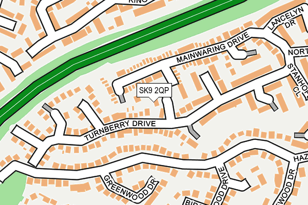
SK9 2QP lies on Sandown Close in Wilmslow. SK9 2QP is located in the Wilmslow Dean Row electoral ward, within the unitary authority of Cheshire East and the English Parliamentary constituency of Tatton. The Sub Integrated Care Board (ICB) Location is NHS Cheshire and Merseyside ICB - 27D and the police force is Cheshire. This postcode has been in use since October 1984.


GetTheData
Source: OS OpenMap – Local (Ordnance Survey)
Source: OS VectorMap District (Ordnance Survey)
Licence: Open Government Licence (requires attribution)
| Easting | 385652 |
| Northing | 381732 |
| Latitude | 53.332302 |
| Longitude | -2.216911 |
GetTheData
Source: Open Postcode Geo
Licence: Open Government Licence
| Street | Sandown Close |
| Town/City | Wilmslow |
| Country | England |
| Postcode District | SK9 |
| ➜ SK9 open data dashboard ➜ See where SK9 is on a map ➜ Where is Wilmslow? | |
GetTheData
Source: Land Registry Price Paid Data
Licence: Open Government Licence
Elevation or altitude of SK9 2QP as distance above sea level:
| Metres | Feet | |
|---|---|---|
| Elevation | 80m | 262ft |
Elevation is measured from the approximate centre of the postcode, to the nearest point on an OS contour line from OS Terrain 50, which has contour spacing of ten vertical metres.
➜ How high above sea level am I? Find the elevation of your current position using your device's GPS.
GetTheData
Source: Open Postcode Elevation
Licence: Open Government Licence
| Ward | Wilmslow Dean Row |
| Constituency | Tatton |
GetTheData
Source: ONS Postcode Database
Licence: Open Government Licence
| September 2023 | Burglary | On or near Fernwood Grove | 257m |
| September 2023 | Violence and sexual offences | On or near Fernwood Grove | 257m |
| June 2023 | Violence and sexual offences | On or near Fernwood Grove | 257m |
| ➜ Get more crime data in our Crime section | |||
GetTheData
Source: data.police.uk
Licence: Open Government Licence
| Wheelock Close (Colshaw Drive) | Wilmslow | 532m |
| Wheelock Close (Colshaw Drive) | Wilmslow | 532m |
| Pinewood Road (Dean Row Road) | Wilmslow | 573m |
| Lincoln Road (Dean Row Road) | Wilmslow | 592m |
| Summerfields (Colshaw Drive) | Wilmslow | 616m |
| Wilmslow Station | 0.9km |
| Handforth Station | 1.6km |
| Styal Station | 2.4km |
GetTheData
Source: NaPTAN
Licence: Open Government Licence
| Percentage of properties with Next Generation Access | 100.0% |
| Percentage of properties with Superfast Broadband | 100.0% |
| Percentage of properties with Ultrafast Broadband | 0.0% |
| Percentage of properties with Full Fibre Broadband | 0.0% |
Superfast Broadband is between 30Mbps and 300Mbps
Ultrafast Broadband is > 300Mbps
| Percentage of properties unable to receive 2Mbps | 0.0% |
| Percentage of properties unable to receive 5Mbps | 0.0% |
| Percentage of properties unable to receive 10Mbps | 0.0% |
| Percentage of properties unable to receive 30Mbps | 0.0% |
GetTheData
Source: Ofcom
Licence: Ofcom Terms of Use (requires attribution)
GetTheData
Source: ONS Postcode Database
Licence: Open Government Licence


➜ Get more ratings from the Food Standards Agency
GetTheData
Source: Food Standards Agency
Licence: FSA terms & conditions
| Last Collection | |||
|---|---|---|---|
| Location | Mon-Fri | Sat | Distance |
| Pinewood Road | 17:15 | 12:00 | 386m |
| Dean Row Road | 17:30 | 12:00 | 509m |
| Wilmslow Park Road | 17:45 | 11:30 | 631m |
GetTheData
Source: Dracos
Licence: Creative Commons Attribution-ShareAlike
| Facility | Distance |
|---|---|
| Energie Fitness Club (Wilmslow) (Closed) Village Way, Wilmslow Swimming Pool, Health and Fitness Gym, Studio | 576m |
| Wilmslow Leisure Centre Station Road, Wilmslow Sports Hall, Swimming Pool, Health and Fitness Gym, Studio, Squash Courts, Artificial Grass Pitch | 973m |
| The Rectory Field Alderley Road, Wilmslow Grass Pitches | 1.1km |
GetTheData
Source: Active Places
Licence: Open Government Licence
| School | Phase of Education | Distance |
|---|---|---|
| The Wilmslow Academy Handforth Road, Wilmslow, SK9 2LX | Primary | 957m |
| Wilmslow Preparatory School Grove Avenue, Wilmslow, SK9 5EG | Not applicable | 1.3km |
| Lacey Green Primary Academy Barlow Road, Wilmslow, SK9 4DP | Primary | 1.3km |
GetTheData
Source: Edubase
Licence: Open Government Licence
The below table lists the International Territorial Level (ITL) codes (formerly Nomenclature of Territorial Units for Statistics (NUTS) codes) and Local Administrative Units (LAU) codes for SK9 2QP:
| ITL 1 Code | Name |
|---|---|
| TLD | North West (England) |
| ITL 2 Code | Name |
| TLD6 | Cheshire |
| ITL 3 Code | Name |
| TLD62 | Cheshire East |
| LAU 1 Code | Name |
| E06000049 | Cheshire East |
GetTheData
Source: ONS Postcode Directory
Licence: Open Government Licence
The below table lists the Census Output Area (OA), Lower Layer Super Output Area (LSOA), and Middle Layer Super Output Area (MSOA) for SK9 2QP:
| Code | Name | |
|---|---|---|
| OA | E00093767 | |
| LSOA | E01018583 | Cheshire East 005A |
| MSOA | E02003857 | Cheshire East 005 |
GetTheData
Source: ONS Postcode Directory
Licence: Open Government Licence
| SK9 2QN | Turnberry Drive | 25m |
| SK9 2QU | Mainwaring Drive | 46m |
| SK9 2QW | Turnberry Drive | 60m |
| SK9 2RE | Carnoustie Close | 67m |
| SK9 2QA | Hazelwood Road | 121m |
| SK9 2QR | Dorchester Close | 123m |
| SK9 2RD | Gleneagles Close | 132m |
| SK9 2RW | Greenwood Drive | 170m |
| SK9 2QD | Mainwaring Drive | 189m |
| SK9 2QT | Muirfield Close | 189m |
GetTheData
Source: Open Postcode Geo; Land Registry Price Paid Data
Licence: Open Government Licence