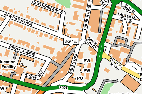
SK9 1EJ is located in the Wilmslow West and Chorley electoral ward, within the unitary authority of Cheshire East and the English Parliamentary constituency of Tatton. The Sub Integrated Care Board (ICB) Location is NHS Cheshire and Merseyside ICB - 27D and the police force is Cheshire. This postcode has been in use since June 1998.


GetTheData
Source: OS OpenMap – Local (Ordnance Survey)
Source: OS VectorMap District (Ordnance Survey)
Licence: Open Government Licence (requires attribution)
| Easting | 384725 |
| Northing | 381200 |
| Latitude | 53.327510 |
| Longitude | -2.230804 |
GetTheData
Source: Open Postcode Geo
Licence: Open Government Licence
| Country | England |
| Postcode District | SK9 |
| ➜ SK9 open data dashboard ➜ See where SK9 is on a map ➜ Where is Wilmslow? | |
GetTheData
Source: Land Registry Price Paid Data
Licence: Open Government Licence
Elevation or altitude of SK9 1EJ as distance above sea level:
| Metres | Feet | |
|---|---|---|
| Elevation | 70m | 230ft |
Elevation is measured from the approximate centre of the postcode, to the nearest point on an OS contour line from OS Terrain 50, which has contour spacing of ten vertical metres.
➜ How high above sea level am I? Find the elevation of your current position using your device's GPS.
GetTheData
Source: Open Postcode Elevation
Licence: Open Government Licence
| Ward | Wilmslow West And Chorley |
| Constituency | Tatton |
GetTheData
Source: ONS Postcode Database
Licence: Open Government Licence
| November 2023 | Violence and sexual offences | On or near Ladyfield Terrace | 289m |
| November 2023 | Other theft | On or near Petrol Station | 500m |
| October 2023 | Violence and sexual offences | On or near Ladyfield Terrace | 289m |
| ➜ Get more crime data in our Crime section | |||
GetTheData
Source: data.police.uk
Licence: Open Government Licence
| Bank Square (Green Lane) | Wilmslow | 61m |
| Bank Square (Green Lane) | Wilmslow | 77m |
| Mill Road (Church Street) | Wilmslow | 171m |
| Alderley Road (Water Lane) | Wilmslow | 237m |
| Alderley Road (Water Lane) | Wilmslow | 257m |
| Wilmslow Station | 0.3km |
| Handforth Station | 2.4km |
| Styal Station | 2.4km |
GetTheData
Source: NaPTAN
Licence: Open Government Licence
GetTheData
Source: ONS Postcode Database
Licence: Open Government Licence

➜ Get more ratings from the Food Standards Agency
GetTheData
Source: Food Standards Agency
Licence: FSA terms & conditions
| Last Collection | |||
|---|---|---|---|
| Location | Mon-Fri | Sat | Distance |
| Hawthorn Lane | 18:15 | 12:45 | 69m |
| 6g Hawthorne Lane | 18:15 | 75m | |
| Green Lane | 18:00 | 12:30 | 167m |
GetTheData
Source: Dracos
Licence: Creative Commons Attribution-ShareAlike
| Facility | Distance |
|---|---|
| Wilmslow Prep School Grove Avenue, Wilmslow Sports Hall, Artificial Grass Pitch | 220m |
| The Rectory Field Alderley Road, Wilmslow Grass Pitches | 231m |
| Wilmslow Leisure Centre Station Road, Wilmslow Sports Hall, Swimming Pool, Health and Fitness Gym, Studio, Squash Courts, Artificial Grass Pitch | 283m |
GetTheData
Source: Active Places
Licence: Open Government Licence
| School | Phase of Education | Distance |
|---|---|---|
| Wilmslow Preparatory School Grove Avenue, Wilmslow, SK9 5EG | Not applicable | 233m |
| Wilmslow High School Holly Road, Wilmslow, SK9 1LZ | Secondary | 597m |
| St Anne's Fulshaw C of E Primary School Nursery Lane, Wilmslow, SK9 5JQ | Primary | 1.1km |
GetTheData
Source: Edubase
Licence: Open Government Licence
The below table lists the International Territorial Level (ITL) codes (formerly Nomenclature of Territorial Units for Statistics (NUTS) codes) and Local Administrative Units (LAU) codes for SK9 1EJ:
| ITL 1 Code | Name |
|---|---|
| TLD | North West (England) |
| ITL 2 Code | Name |
| TLD6 | Cheshire |
| ITL 3 Code | Name |
| TLD62 | Cheshire East |
| LAU 1 Code | Name |
| E06000049 | Cheshire East |
GetTheData
Source: ONS Postcode Directory
Licence: Open Government Licence
The below table lists the Census Output Area (OA), Lower Layer Super Output Area (LSOA), and Middle Layer Super Output Area (MSOA) for SK9 1EJ:
| Code | Name | |
|---|---|---|
| OA | E00093873 | |
| LSOA | E01018602 | Cheshire East 006C |
| MSOA | E02003858 | Cheshire East 006 |
GetTheData
Source: ONS Postcode Directory
Licence: Open Government Licence
| SK9 1DR | Grove Street | 44m |
| SK9 1LL | Green Lane | 50m |
| SK9 1AA | Hawthorn Lane | 51m |
| SK9 1AN | Bank Square | 55m |
| SK9 1DU | Grove Street | 67m |
| SK9 1AX | Church Street | 120m |
| SK9 1LD | Green Lane | 126m |
| SK9 1BQ | Manchester Road | 151m |
| SK9 5DD | Hawthorn Lane | 166m |
| SK9 1DS | Grove Street | 168m |
GetTheData
Source: Open Postcode Geo; Land Registry Price Paid Data
Licence: Open Government Licence