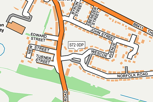
S72 0DP lies on Wescoe Avenue in Great Houghton, Barnsley. S72 0DP is located in the North East electoral ward, within the metropolitan district of Barnsley and the English Parliamentary constituency of Barnsley East. The Sub Integrated Care Board (ICB) Location is NHS South Yorkshire ICB - 02P and the police force is South Yorkshire. This postcode has been in use since January 1980.


GetTheData
Source: OS OpenMap – Local (Ordnance Survey)
Source: OS VectorMap District (Ordnance Survey)
Licence: Open Government Licence (requires attribution)
| Easting | 443442 |
| Northing | 406118 |
| Latitude | 53.549905 |
| Longitude | -1.345803 |
GetTheData
Source: Open Postcode Geo
Licence: Open Government Licence
| Street | Wescoe Avenue |
| Locality | Great Houghton |
| Town/City | Barnsley |
| Country | England |
| Postcode District | S72 |
➜ See where S72 is on a map ➜ Where is Great Houghton? | |
GetTheData
Source: Land Registry Price Paid Data
Licence: Open Government Licence
Elevation or altitude of S72 0DP as distance above sea level:
| Metres | Feet | |
|---|---|---|
| Elevation | 50m | 164ft |
Elevation is measured from the approximate centre of the postcode, to the nearest point on an OS contour line from OS Terrain 50, which has contour spacing of ten vertical metres.
➜ How high above sea level am I? Find the elevation of your current position using your device's GPS.
GetTheData
Source: Open Postcode Elevation
Licence: Open Government Licence
| Ward | North East |
| Constituency | Barnsley East |
GetTheData
Source: ONS Postcode Database
Licence: Open Government Licence
| Edward Street (Rotherham Road) | Great Houghton | 66m |
| Turner Street (Rotherham Road) | Great Houghton | 79m |
| Byron Street (Thurnscoe Lane) | Great Houghton | 202m |
| Thurnscoe Lane (Rotherham Road) | Great Houghton | 226m |
| Ebenezer Street (Thurnscoe Lane) | Great Houghton | 234m |
| Thurnscoe Station | 2.5km |
| Goldthorpe Station | 2.8km |
| Bolton-Upon-Dearne Station | 4.1km |
GetTheData
Source: NaPTAN
Licence: Open Government Licence
| Percentage of properties with Next Generation Access | 100.0% |
| Percentage of properties with Superfast Broadband | 100.0% |
| Percentage of properties with Ultrafast Broadband | 60.0% |
| Percentage of properties with Full Fibre Broadband | 0.0% |
Superfast Broadband is between 30Mbps and 300Mbps
Ultrafast Broadband is > 300Mbps
| Median download speed | 69.9Mbps |
| Average download speed | 59.2Mbps |
| Maximum download speed | 81.43Mbps |
| Median upload speed | 17.0Mbps |
| Average upload speed | 14.3Mbps |
| Maximum upload speed | 20.36Mbps |
| Percentage of properties unable to receive 2Mbps | 0.0% |
| Percentage of properties unable to receive 5Mbps | 0.0% |
| Percentage of properties unable to receive 10Mbps | 0.0% |
| Percentage of properties unable to receive 30Mbps | 0.0% |
GetTheData
Source: Ofcom
Licence: Ofcom Terms of Use (requires attribution)
Estimated total energy consumption in S72 0DP by fuel type, 2015.
| Consumption (kWh) | 128,843 |
|---|---|
| Meter count | 10 |
| Mean (kWh/meter) | 12,884 |
| Median (kWh/meter) | 12,933 |
| Consumption (kWh) | 39,421 |
|---|---|
| Meter count | 10 |
| Mean (kWh/meter) | 3,942 |
| Median (kWh/meter) | 3,843 |
GetTheData
Source: Postcode level gas estimates: 2015 (experimental)
Source: Postcode level electricity estimates: 2015 (experimental)
Licence: Open Government Licence
GetTheData
Source: ONS Postcode Database
Licence: Open Government Licence


➜ Get more ratings from the Food Standards Agency
GetTheData
Source: Food Standards Agency
Licence: FSA terms & conditions
| Last Collection | |||
|---|---|---|---|
| Location | Mon-Fri | Sat | Distance |
| 41 Rotherham Road | 16:15 | 12:00 | 115m |
| Post Office 19-21 High St | 16:15 | 12:00 | 354m |
| Post Office Rotherham Road | 16:30 | 12:00 | 1,028m |
GetTheData
Source: Dracos
Licence: Creative Commons Attribution-ShareAlike
The below table lists the International Territorial Level (ITL) codes (formerly Nomenclature of Territorial Units for Statistics (NUTS) codes) and Local Administrative Units (LAU) codes for S72 0DP:
| ITL 1 Code | Name |
|---|---|
| TLE | Yorkshire and The Humber |
| ITL 2 Code | Name |
| TLE3 | South Yorkshire |
| ITL 3 Code | Name |
| TLE31 | Barnsley, Doncaster and Rotherham |
| LAU 1 Code | Name |
| E08000016 | Barnsley |
GetTheData
Source: ONS Postcode Directory
Licence: Open Government Licence
The below table lists the Census Output Area (OA), Lower Layer Super Output Area (LSOA), and Middle Layer Super Output Area (MSOA) for S72 0DP:
| Code | Name | |
|---|---|---|
| OA | E00037268 | |
| LSOA | E01007349 | Barnsley 020B |
| MSOA | E02001528 | Barnsley 020 |
GetTheData
Source: ONS Postcode Directory
Licence: Open Government Licence
| S72 0DW | Wescoe Avenue | 69m |
| S72 0DG | Rotherham Road | 84m |
| S72 0EB | John Street | 88m |
| S72 0DH | Rotherham Road | 89m |
| S72 0DR | Wescoe Avenue | 116m |
| S72 0DF | Rotherham Road | 118m |
| S72 0DQ | Edward Street | 128m |
| S72 0DL | Turner Street | 141m |
| S72 0DJ | New Street | 144m |
| S72 0DZ | Ebenezer Street | 145m |
GetTheData
Source: Open Postcode Geo; Land Registry Price Paid Data
Licence: Open Government Licence