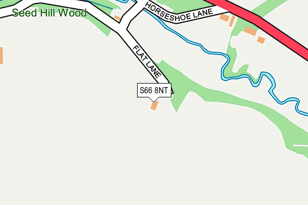
S66 8NT is located in the Dinnington electoral ward, within the metropolitan district of Rotherham and the English Parliamentary constituency of Rother Valley. The Sub Integrated Care Board (ICB) Location is NHS South Yorkshire ICB - 03L and the police force is South Yorkshire. This postcode has been in use since January 1980.


GetTheData
Source: OS OpenMap – Local (Ordnance Survey)
Source: OS VectorMap District (Ordnance Survey)
Licence: Open Government Licence (requires attribution)
| Easting | 455502 |
| Northing | 389563 |
| Latitude | 53.400003 |
| Longitude | -1.166721 |
GetTheData
Source: Open Postcode Geo
Licence: Open Government Licence
| Country | England |
| Postcode District | S66 |
| ➜ S66 open data dashboard ➜ See where S66 is on a map ➜ Where is Stone? | |
GetTheData
Source: Land Registry Price Paid Data
Licence: Open Government Licence
Elevation or altitude of S66 8NT as distance above sea level:
| Metres | Feet | |
|---|---|---|
| Elevation | 60m | 197ft |
Elevation is measured from the approximate centre of the postcode, to the nearest point on an OS contour line from OS Terrain 50, which has contour spacing of ten vertical metres.
➜ How high above sea level am I? Find the elevation of your current position using your device's GPS.
GetTheData
Source: Open Postcode Elevation
Licence: Open Government Licence
| Ward | Dinnington |
| Constituency | Rother Valley |
GetTheData
Source: ONS Postcode Database
Licence: Open Government Licence
| May 2022 | Criminal damage and arson | On or near A634 | 291m |
| May 2022 | Burglary | On or near A634 | 291m |
| April 2022 | Violence and sexual offences | On or near A634 | 291m |
| ➜ Get more crime data in our Crime section | |||
GetTheData
Source: data.police.uk
Licence: Open Government Licence
| Park Hill Drive (New Road) | Firbeck | 1,352m |
GetTheData
Source: NaPTAN
Licence: Open Government Licence
| Percentage of properties with Next Generation Access | 100.0% |
| Percentage of properties with Superfast Broadband | 100.0% |
| Percentage of properties with Ultrafast Broadband | 100.0% |
| Percentage of properties with Full Fibre Broadband | 100.0% |
Superfast Broadband is between 30Mbps and 300Mbps
Ultrafast Broadband is > 300Mbps
| Percentage of properties unable to receive 2Mbps | 0.0% |
| Percentage of properties unable to receive 5Mbps | 0.0% |
| Percentage of properties unable to receive 10Mbps | 0.0% |
| Percentage of properties unable to receive 30Mbps | 0.0% |
GetTheData
Source: Ofcom
Licence: Ofcom Terms of Use (requires attribution)
GetTheData
Source: ONS Postcode Database
Licence: Open Government Licence


➜ Get more ratings from the Food Standards Agency
GetTheData
Source: Food Standards Agency
Licence: FSA terms & conditions
| Last Collection | |||
|---|---|---|---|
| Location | Mon-Fri | Sat | Distance |
| Stone | 16:00 | 11:00 | 461m |
| Home Farm | 16:15 | 11:00 | 885m |
| Roche Abbey | 16:00 | 11:00 | 1,285m |
GetTheData
Source: Dracos
Licence: Creative Commons Attribution-ShareAlike
| Facility | Distance |
|---|---|
| Maltby Miners Welfare Muglet Lane, Maltby, Rotherham Grass Pitches | 2.7km |
| Coronation Park (Maltby) Hamilton Road, Maltby, Rotherham Outdoor Tennis Courts | 2.9km |
| Langold Dyscarr Community School School Road, Langold, Worksop Artificial Grass Pitch, Grass Pitches | 3.3km |
GetTheData
Source: Active Places
Licence: Open Government Licence
| School | Phase of Education | Distance |
|---|---|---|
| St Mary's Catholic Primary School (Maltby) Muglet Lane, Maltby, Rotherham, S66 7JU | Primary | 2.8km |
| Crags Community School Strauss Crescent, Maltby, Rotherham, S66 7QJ | Primary | 2.8km |
| Langold Dyscarr Community School School Road, Langold, Worksop, S81 9PX | Primary | 3.4km |
GetTheData
Source: Edubase
Licence: Open Government Licence
The below table lists the International Territorial Level (ITL) codes (formerly Nomenclature of Territorial Units for Statistics (NUTS) codes) and Local Administrative Units (LAU) codes for S66 8NT:
| ITL 1 Code | Name |
|---|---|
| TLE | Yorkshire and The Humber |
| ITL 2 Code | Name |
| TLE3 | South Yorkshire |
| ITL 3 Code | Name |
| TLE31 | Barnsley, Doncaster and Rotherham |
| LAU 1 Code | Name |
| E08000018 | Rotherham |
GetTheData
Source: ONS Postcode Directory
Licence: Open Government Licence
The below table lists the Census Output Area (OA), Lower Layer Super Output Area (LSOA), and Middle Layer Super Output Area (MSOA) for S66 8NT:
| Code | Name | |
|---|---|---|
| OA | E00039463 | |
| LSOA | E01007788 | Rotherham 028B |
| MSOA | E02001605 | Rotherham 028 |
GetTheData
Source: ONS Postcode Directory
Licence: Open Government Licence
| S66 8NU | Stone | 224m |
| S81 8NY | Blyth Road | 1056m |
| S81 8JU | St Martins Close | 1252m |
| S81 8JT | New Road | 1285m |
| S66 8NW | 1312m | |
| S81 8JX | Lime Avenue | 1330m |
| S81 8JR | 1330m | |
| S81 8JY | New Road | 1346m |
| S81 8LN | Kingswood Court | 1365m |
| S81 8LH | Salt Hill | 1381m |
GetTheData
Source: Open Postcode Geo; Land Registry Price Paid Data
Licence: Open Government Licence