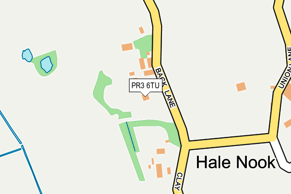
PR3 6TU is located in the Great Eccleston electoral ward, within the local authority district of Wyre and the English Parliamentary constituency of Wyre and Preston North. The Sub Integrated Care Board (ICB) Location is NHS Lancashire and South Cumbria ICB - 02M and the police force is Lancashire. This postcode has been in use since May 2010.


GetTheData
Source: OS OpenMap – Local (Ordnance Survey)
Source: OS VectorMap District (Ordnance Survey)
Licence: Open Government Licence (requires attribution)
| Easting | 339056 |
| Northing | 444282 |
| Latitude | 53.891133 |
| Longitude | -2.928787 |
GetTheData
Source: Open Postcode Geo
Licence: Open Government Licence
| Country | England |
| Postcode District | PR3 |
| ➜ PR3 open data dashboard ➜ See where PR3 is on a map ➜ Where is Hale Nook? | |
GetTheData
Source: Land Registry Price Paid Data
Licence: Open Government Licence
Elevation or altitude of PR3 6TU as distance above sea level:
| Metres | Feet | |
|---|---|---|
| Elevation | 10m | 33ft |
Elevation is measured from the approximate centre of the postcode, to the nearest point on an OS contour line from OS Terrain 50, which has contour spacing of ten vertical metres.
➜ How high above sea level am I? Find the elevation of your current position using your device's GPS.
GetTheData
Source: Open Postcode Elevation
Licence: Open Government Licence
| Ward | Great Eccleston |
| Constituency | Wyre And Preston North |
GetTheData
Source: ONS Postcode Database
Licence: Open Government Licence
| April 2021 | Violence and sexual offences | On or near Back Lane | 28m |
| ➜ Get more crime data in our Crime section | |||
GetTheData
Source: data.police.uk
Licence: Open Government Licence
| Hale Worth Farm (Back Lane) | Hale Nook | 309m |
| Country Park (Ned's Lane) | Stalmine | 1,327m |
| Back Lane | Stalmine | 1,505m |
| Moss Side Lane | Stalmine | 1,582m |
| Carr House Farm (Union Lane) | Out Rawcliffe | 1,892m |
| Poulton-le-Fylde Station | 6.3km |
GetTheData
Source: NaPTAN
Licence: Open Government Licence
| Percentage of properties with Next Generation Access | 100.0% |
| Percentage of properties with Superfast Broadband | 100.0% |
| Percentage of properties with Ultrafast Broadband | 100.0% |
| Percentage of properties with Full Fibre Broadband | 100.0% |
Superfast Broadband is between 30Mbps and 300Mbps
Ultrafast Broadband is > 300Mbps
| Percentage of properties unable to receive 2Mbps | 0.0% |
| Percentage of properties unable to receive 5Mbps | 0.0% |
| Percentage of properties unable to receive 10Mbps | 0.0% |
| Percentage of properties unable to receive 30Mbps | 0.0% |
GetTheData
Source: Ofcom
Licence: Ofcom Terms of Use (requires attribution)
GetTheData
Source: ONS Postcode Database
Licence: Open Government Licence


➜ Get more ratings from the Food Standards Agency
GetTheData
Source: Food Standards Agency
Licence: FSA terms & conditions
| Last Collection | |||
|---|---|---|---|
| Location | Mon-Fri | Sat | Distance |
| Stalmine Post Office | 17:00 | 11:15 | 2,003m |
| Stricklands Lane | 17:00 | 11:30 | 2,015m |
| Hambleton Post Office | 17:30 | 11:45 | 2,464m |
GetTheData
Source: Dracos
Licence: Creative Commons Attribution-ShareAlike
| Facility | Distance |
|---|---|
| Stalmine Primary School Mill Lane, Stalmine, Poulton-le-fylde Grass Pitches | 1.8km |
| Hambleton Primary Academy Church Lane, Hambleton, Poulton-le-fylde Grass Pitches | 2.2km |
| Hallgate Park Hall Gate Lane, Preesall, Poulton-le-fylde Grass Pitches | 2.2km |
GetTheData
Source: Active Places
Licence: Open Government Licence
| School | Phase of Education | Distance |
|---|---|---|
| Stalmine Primary School Mill Lane, Stalmine, Poulton-le-Fylde, FY6 0LR | Primary | 1.8km |
| Hambleton Primary Academy Church Lane, Hambleton, Poulton-le-Fylde, FY6 9BZ | Primary | 2.2km |
| Saint Aidan's Church of England High School Cartgate, Preesall, Poulton-le-Fylde, FY6 0NP | Secondary | 3.6km |
GetTheData
Source: Edubase
Licence: Open Government Licence
The below table lists the International Territorial Level (ITL) codes (formerly Nomenclature of Territorial Units for Statistics (NUTS) codes) and Local Administrative Units (LAU) codes for PR3 6TU:
| ITL 1 Code | Name |
|---|---|
| TLD | North West (England) |
| ITL 2 Code | Name |
| TLD4 | Lancashire |
| ITL 3 Code | Name |
| TLD44 | Lancaster and Wyre |
| LAU 1 Code | Name |
| E07000128 | Wyre |
GetTheData
Source: ONS Postcode Directory
Licence: Open Government Licence
The below table lists the Census Output Area (OA), Lower Layer Super Output Area (LSOA), and Middle Layer Super Output Area (MSOA) for PR3 6TU:
| Code | Name | |
|---|---|---|
| OA | E00129718 | |
| LSOA | E01025562 | Wyre 009B |
| MSOA | E02005327 | Wyre 009 |
GetTheData
Source: ONS Postcode Directory
Licence: Open Government Licence
| PR3 6ST | Hale Nook | 390m |
| PR3 6SU | Clay Gap Lane | 726m |
| FY6 9DH | Whitemoss Lane | 811m |
| FY6 0JW | Moss Side Lane | 1038m |
| FY6 0JP | Moss Side Lane | 1086m |
| FY6 0LN | Back Lane | 1123m |
| PR3 6SX | Knitting Row | 1168m |
| FY6 0JN | Back Lane | 1305m |
| FY6 0LW | Neds Lane | 1337m |
| FY6 0JL | Neds Lane | 1398m |
GetTheData
Source: Open Postcode Geo; Land Registry Price Paid Data
Licence: Open Government Licence