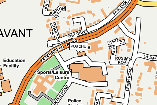
PO9 2HU is located in the St Faith's electoral ward, within the local authority district of Havant and the English Parliamentary constituency of Havant. The Sub Integrated Care Board (ICB) Location is NHS Hampshire and Isle of Wight ICB - D9Y0V and the police force is Hampshire. This postcode has been in use since January 1980.


GetTheData
Source: OS OpenMap – Local (Ordnance Survey)
Source: OS VectorMap District (Ordnance Survey)
Licence: Open Government Licence (requires attribution)
| Easting | 471720 |
| Northing | 107048 |
| Latitude | 50.858496 |
| Longitude | -0.982374 |
GetTheData
Source: Open Postcode Geo
Licence: Open Government Licence
| Country | England |
| Postcode District | PO9 |
| ➜ PO9 open data dashboard ➜ See where PO9 is on a map ➜ Where is Havant? | |
GetTheData
Source: Land Registry Price Paid Data
Licence: Open Government Licence
Elevation or altitude of PO9 2HU as distance above sea level:
| Metres | Feet | |
|---|---|---|
| Elevation | 20m | 66ft |
Elevation is measured from the approximate centre of the postcode, to the nearest point on an OS contour line from OS Terrain 50, which has contour spacing of ten vertical metres.
➜ How high above sea level am I? Find the elevation of your current position using your device's GPS.
GetTheData
Source: Open Postcode Elevation
Licence: Open Government Licence
| Ward | St Faith's |
| Constituency | Havant |
GetTheData
Source: ONS Postcode Database
Licence: Open Government Licence
| December 2023 | Anti-social behaviour | On or near Fern Drive | 434m |
| October 2023 | Violence and sexual offences | On or near Fern Drive | 434m |
| September 2023 | Violence and sexual offences | On or near Fern Drive | 434m |
| ➜ Get more crime data in our Crime section | |||
GetTheData
Source: data.police.uk
Licence: Open Government Licence
| Leisure Centre (Civic Centre Road) | Havant | 80m |
| Civic Centre (B2149 Petersfield Road) | Leigh Park | 81m |
| Leisure Centre (Civic Centre Road) | Havant | 81m |
| The Curlew (Petersfield Road) | Leigh Park | 254m |
| Crossland Drive (Petersfield Road) | Leigh Park | 325m |
| Havant Station | 0.5km |
| Bedhampton Station | 1.1km |
| Warblington Station | 1.2km |
GetTheData
Source: NaPTAN
Licence: Open Government Licence
GetTheData
Source: ONS Postcode Database
Licence: Open Government Licence


➜ Get more ratings from the Food Standards Agency
GetTheData
Source: Food Standards Agency
Licence: FSA terms & conditions
| Last Collection | |||
|---|---|---|---|
| Location | Mon-Fri | Sat | Distance |
| Crosslands Drive | 16:00 | 11:45 | 372m |
| Market Parade | 18:50 | 12:00 | 531m |
| Stockheath Lane | 18:00 | 11:45 | 538m |
GetTheData
Source: Dracos
Licence: Creative Commons Attribution-ShareAlike
| Facility | Distance |
|---|---|
| Havant Leisure Centre Civic Centre Road, Havant Sports Hall, Indoor Bowls, Swimming Pool, Health and Fitness Gym, Studio, Squash Courts | 96m |
| Trosnant Junior School Chilcombe Close, Havant Grass Pitches | 333m |
| Hsdc Havant New Road, Havant Grass Pitches, Sports Hall, Artificial Grass Pitch | 386m |
GetTheData
Source: Active Places
Licence: Open Government Licence
| School | Phase of Education | Distance |
|---|---|---|
| Trosnant Junior School Stockheath Lane, Leigh Park, Havant, PO9 3BD | Primary | 369m |
| Trosnant Infant School Stockheath Lane, Leigh Park, Havant, PO9 3BD | Primary | 369m |
| Fairfield Infant School Fairfield Road, Havant, PO9 1AY | Primary | 666m |
GetTheData
Source: Edubase
Licence: Open Government Licence
The below table lists the International Territorial Level (ITL) codes (formerly Nomenclature of Territorial Units for Statistics (NUTS) codes) and Local Administrative Units (LAU) codes for PO9 2HU:
| ITL 1 Code | Name |
|---|---|
| TLJ | South East (England) |
| ITL 2 Code | Name |
| TLJ3 | Hampshire and Isle of Wight |
| ITL 3 Code | Name |
| TLJ35 | South Hampshire |
| LAU 1 Code | Name |
| E07000090 | Havant |
GetTheData
Source: ONS Postcode Directory
Licence: Open Government Licence
The below table lists the Census Output Area (OA), Lower Layer Super Output Area (LSOA), and Middle Layer Super Output Area (MSOA) for PO9 2HU:
| Code | Name | |
|---|---|---|
| OA | E00116643 | |
| LSOA | E01022957 | Havant 014E |
| MSOA | E02004775 | Havant 014 |
GetTheData
Source: ONS Postcode Directory
Licence: Open Government Licence
| PO9 2BY | The Drive | 88m |
| PO9 2BZ | Fitzwygram Crescent | 147m |
| PO9 2DA | Compton Close | 150m |
| PO9 2DG | Russell Road | 152m |
| PO9 2DH | Havant Farm Close | 155m |
| PO9 2EU | Leigh Road | 201m |
| PO9 2BQ | Blendworth Crescent | 222m |
| PO9 2BN | Holybourne Road | 233m |
| PO9 2AD | Elm Park Road | 244m |
| PO9 2BX | Fair Oak Drive | 250m |
GetTheData
Source: Open Postcode Geo; Land Registry Price Paid Data
Licence: Open Government Licence