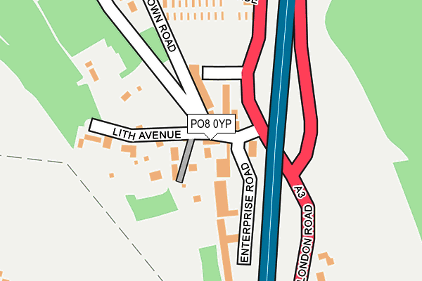
PO8 0YP is located in the Horndean Downs electoral ward, within the local authority district of East Hampshire and the English Parliamentary constituency of Meon Valley. The Sub Integrated Care Board (ICB) Location is NHS Hampshire and Isle of Wight ICB - D9Y0V and the police force is Hampshire. This postcode has been in use since May 1994.


GetTheData
Source: OS OpenMap – Local (Ordnance Survey)
Source: OS VectorMap District (Ordnance Survey)
Licence: Open Government Licence (requires attribution)
| Easting | 470413 |
| Northing | 113866 |
| Latitude | 50.919967 |
| Longitude | -0.999644 |
GetTheData
Source: Open Postcode Geo
Licence: Open Government Licence
| Country | England |
| Postcode District | PO8 |
| ➜ PO8 open data dashboard ➜ See where PO8 is on a map ➜ Where is Horndean? | |
GetTheData
Source: Land Registry Price Paid Data
Licence: Open Government Licence
Elevation or altitude of PO8 0YP as distance above sea level:
| Metres | Feet | |
|---|---|---|
| Elevation | 80m | 262ft |
Elevation is measured from the approximate centre of the postcode, to the nearest point on an OS contour line from OS Terrain 50, which has contour spacing of ten vertical metres.
➜ How high above sea level am I? Find the elevation of your current position using your device's GPS.
GetTheData
Source: Open Postcode Elevation
Licence: Open Government Licence
| Ward | Horndean Downs |
| Constituency | Meon Valley |
GetTheData
Source: ONS Postcode Database
Licence: Open Government Licence
| November 2023 | Violence and sexual offences | On or near Comfrey Close | 257m |
| August 2023 | Public order | On or near The Yews | 433m |
| May 2023 | Anti-social behaviour | On or near Down Road | 355m |
| ➜ Get more crime data in our Crime section | |||
GetTheData
Source: data.police.uk
Licence: Open Government Licence
| Downwood Way (London Road) | Horndean | 210m |
| Downwood Way (London Road) | Horndean | 262m |
| Anchor Terrace (A3 London Road) | Horndean | 430m |
| Anchor Terrace (A3 London Road) | Horndean | 473m |
| South Road (London Road) | Horndean | 481m |
| Rowlands Castle Station | 4.3km |
GetTheData
Source: NaPTAN
Licence: Open Government Licence
GetTheData
Source: ONS Postcode Database
Licence: Open Government Licence


➜ Get more ratings from the Food Standards Agency
GetTheData
Source: Food Standards Agency
Licence: FSA terms & conditions
| Last Collection | |||
|---|---|---|---|
| Location | Mon-Fri | Sat | Distance |
| Down Road | 16:00 | 11:30 | 116m |
| Fiveheads | 16:15 | 11:45 | 496m |
| Southdown Road | 16:00 | 11:30 | 662m |
GetTheData
Source: Dracos
Licence: Creative Commons Attribution-ShareAlike
| Facility | Distance |
|---|---|
| The Rec Five Heads Road, Waterlooville Grass Pitches | 554m |
| Horndean Technology College Barton Cross, Waterlooville Sports Hall, Health and Fitness Gym, Artificial Grass Pitch, Grass Pitches, Studio, Outdoor Tennis Courts | 919m |
| Rusalka Swim School Blendworth Lane, Horndean, Waterlooville Swimming Pool | 975m |
GetTheData
Source: Active Places
Licence: Open Government Licence
| School | Phase of Education | Distance |
|---|---|---|
| Horndean Church of England Junior School Five Heads Road, Horndean, Waterlooville, PO8 9NW | Primary | 710m |
| Horndean Infant School Merchistoun Road, Horndean, Waterlooville, PO8 9LS | Primary | 771m |
| Horndean Technology College Barton Cross, Horndean, Waterlooville, PO8 9PQ | Secondary | 919m |
GetTheData
Source: Edubase
Licence: Open Government Licence
The below table lists the International Territorial Level (ITL) codes (formerly Nomenclature of Territorial Units for Statistics (NUTS) codes) and Local Administrative Units (LAU) codes for PO8 0YP:
| ITL 1 Code | Name |
|---|---|
| TLJ | South East (England) |
| ITL 2 Code | Name |
| TLJ3 | Hampshire and Isle of Wight |
| ITL 3 Code | Name |
| TLJ36 | Central Hampshire |
| LAU 1 Code | Name |
| E07000085 | East Hampshire |
GetTheData
Source: ONS Postcode Directory
Licence: Open Government Licence
The below table lists the Census Output Area (OA), Lower Layer Super Output Area (LSOA), and Middle Layer Super Output Area (MSOA) for PO8 0YP:
| Code | Name | |
|---|---|---|
| OA | E00114928 | |
| LSOA | E01022606 | East Hampshire 014A |
| MSOA | E02004710 | East Hampshire 014 |
GetTheData
Source: ONS Postcode Directory
Licence: Open Government Licence
| PO8 0BP | London Road | 55m |
| PO8 0BB | Enterprise Industrial Estate | 84m |
| PO8 0HA | Lith Avenue | 88m |
| PO8 0BT | Highcroft Industrial Estate | 168m |
| PO8 0BS | Lith Avenue | 176m |
| PO8 0XR | Lith Crescent | 207m |
| PO8 0EU | Down Road | 257m |
| PO8 0JQ | Comfrey Close | 265m |
| PO8 0HQ | London Road | 279m |
| PO8 0BU | London Road | 288m |
GetTheData
Source: Open Postcode Geo; Land Registry Price Paid Data
Licence: Open Government Licence