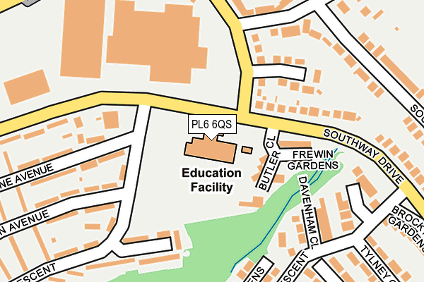
PL6 6QS is located in the Southway electoral ward, within the unitary authority of Plymouth and the English Parliamentary constituency of Plymouth, Moor View. The Sub Integrated Care Board (ICB) Location is NHS Devon ICB - 15N and the police force is Devon & Cornwall. This postcode has been in use since November 2010.


GetTheData
Source: OS OpenMap – Local (Ordnance Survey)
Source: OS VectorMap District (Ordnance Survey)
Licence: Open Government Licence (requires attribution)
| Easting | 249479 |
| Northing | 60989 |
| Latitude | 50.429411 |
| Longitude | -4.120600 |
GetTheData
Source: Open Postcode Geo
Licence: Open Government Licence
| Country | England |
| Postcode District | PL6 |
| ➜ PL6 open data dashboard ➜ See where PL6 is on a map ➜ Where is Plymouth? | |
GetTheData
Source: Land Registry Price Paid Data
Licence: Open Government Licence
Elevation or altitude of PL6 6QS as distance above sea level:
| Metres | Feet | |
|---|---|---|
| Elevation | 120m | 394ft |
Elevation is measured from the approximate centre of the postcode, to the nearest point on an OS contour line from OS Terrain 50, which has contour spacing of ten vertical metres.
➜ How high above sea level am I? Find the elevation of your current position using your device's GPS.
GetTheData
Source: Open Postcode Elevation
Licence: Open Government Licence
| Ward | Southway |
| Constituency | Plymouth, Moor View |
GetTheData
Source: ONS Postcode Database
Licence: Open Government Licence
| June 2022 | Other theft | On or near Butler Close | 90m |
| June 2022 | Violence and sexual offences | On or near Frewin Gardens | 116m |
| June 2022 | Violence and sexual offences | On or near Launceston Close | 136m |
| ➜ Get more crime data in our Crime section | |||
GetTheData
Source: data.police.uk
Licence: Open Government Licence
| Oakwood Primary School (Southway Drive) | Southway | 67m |
| Oakwood Primary School (Southway Drive) | Southway | 95m |
| Butler Close (Southway Drive) | Southway | 111m |
| Samuel Basset Avenue (Clittaford Road) | Southway | 205m |
| Corsham Close (Barndale Crescent) | Southway | 253m |
| Bere Ferrers Station | 5km |
| St Budeaux Victoria Road Station | 5.6km |
| St Budeaux Ferry Road Station | 5.6km |
GetTheData
Source: NaPTAN
Licence: Open Government Licence
GetTheData
Source: ONS Postcode Database
Licence: Open Government Licence


➜ Get more ratings from the Food Standards Agency
GetTheData
Source: Food Standards Agency
Licence: FSA terms & conditions
| Last Collection | |||
|---|---|---|---|
| Location | Mon-Fri | Sat | Distance |
| Clittaford Road | 17:15 | 12:00 | 809m |
| Beverston Way | 17:30 | 12:30 | 907m |
| Tesco (Roborough) | 17:30 | 12:30 | 1,091m |
GetTheData
Source: Dracos
Licence: Creative Commons Attribution-ShareAlike
| Facility | Distance |
|---|---|
| Langley Junior (Closed) Pendeen Crescent, Plymouth Grass Pitches | 45m |
| Widewell Primary Academy Lulworth Drive, Plymouth Grass Pitches, Sports Hall, Artificial Grass Pitch | 445m |
| Plymouth College (Delgany Sports Ground) Delgany View, Derriford, Plymouth Grass Pitches | 859m |
GetTheData
Source: Active Places
Licence: Open Government Licence
| School | Phase of Education | Distance |
|---|---|---|
| Oakwood Primary Academy Pendeen Crescent, Southway, Plymouth, PL6 6QS | Primary | 45m |
| Widewell Primary Academy Lulworth Drive, Roborough, Plymouth, PL6 7ER | Primary | 477m |
| Beechwood Primary Academy 31 Rockfield Avenue, Southway, Plymouth, PL6 6DX | Primary | 854m |
GetTheData
Source: Edubase
Licence: Open Government Licence
The below table lists the International Territorial Level (ITL) codes (formerly Nomenclature of Territorial Units for Statistics (NUTS) codes) and Local Administrative Units (LAU) codes for PL6 6QS:
| ITL 1 Code | Name |
|---|---|
| TLK | South West (England) |
| ITL 2 Code | Name |
| TLK4 | Devon |
| ITL 3 Code | Name |
| TLK41 | Plymouth |
| LAU 1 Code | Name |
| E06000026 | Plymouth |
GetTheData
Source: ONS Postcode Directory
Licence: Open Government Licence
The below table lists the Census Output Area (OA), Lower Layer Super Output Area (LSOA), and Middle Layer Super Output Area (MSOA) for PL6 6QS:
| Code | Name | |
|---|---|---|
| OA | E00076596 | |
| LSOA | E01015160 | Plymouth 001C |
| MSOA | E02003122 | Plymouth 001 |
GetTheData
Source: ONS Postcode Directory
Licence: Open Government Licence
| PL6 6PL | Butler Close | 79m |
| PL6 6PN | Frewin Gardens | 110m |
| PL6 6DD | Launceston Close | 130m |
| PL6 6DB | Clittaford Road | 137m |
| PL6 6BZ | Southway Drive | 140m |
| PL6 7DS | Lulworth Drive | 191m |
| PL6 6BT | Davenham Close | 200m |
| PL6 6RA | Longstone Avenue | 207m |
| PL6 6RG | Pendeen Crescent | 215m |
| PL6 6RL | Goodwin Avenue | 218m |
GetTheData
Source: Open Postcode Geo; Land Registry Price Paid Data
Licence: Open Government Licence