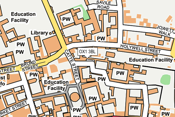
OX1 3BL is located in the Holywell electoral ward, within the local authority district of Oxford and the English Parliamentary constituency of Oxford East. The Sub Integrated Care Board (ICB) Location is NHS Buckinghamshire, Oxfordshire and Berkshire West ICB - 10Q and the police force is Thames Valley. This postcode has been in use since January 1980.


GetTheData
Source: OS OpenMap – Local (Ordnance Survey)
Source: OS VectorMap District (Ordnance Survey)
Licence: Open Government Licence (requires attribution)
| Easting | 451636 |
| Northing | 206476 |
| Latitude | 51.754603 |
| Longitude | -1.253345 |
GetTheData
Source: Open Postcode Geo
Licence: Open Government Licence
| Country | England |
| Postcode District | OX1 |
| ➜ OX1 open data dashboard ➜ See where OX1 is on a map ➜ Where is Oxford? | |
GetTheData
Source: Land Registry Price Paid Data
Licence: Open Government Licence
Elevation or altitude of OX1 3BL as distance above sea level:
| Metres | Feet | |
|---|---|---|
| Elevation | 60m | 197ft |
Elevation is measured from the approximate centre of the postcode, to the nearest point on an OS contour line from OS Terrain 50, which has contour spacing of ten vertical metres.
➜ How high above sea level am I? Find the elevation of your current position using your device's GPS.
GetTheData
Source: Open Postcode Elevation
Licence: Open Government Licence
| Ward | Holywell |
| Constituency | Oxford East |
GetTheData
Source: ONS Postcode Database
Licence: Open Government Licence
| January 2024 | Bicycle theft | On or near Further/Higher Educational Building | 344m |
| January 2024 | Other theft | On or near Further/Higher Educational Building | 344m |
| January 2024 | Violence and sexual offences | On or near Further/Higher Educational Building | 344m |
| ➜ Get more crime data in our Crime section | |||
GetTheData
Source: data.police.uk
Licence: Open Government Licence
| Broad Street | Oxford City Centre | 213m |
| Queens Lane (High Street) | Oxford City Centre | 237m |
| Queens Lane (High Street) | Oxford City Centre | 244m |
| Queens Lane (High Street) | Oxford City Centre | 250m |
| Broad Street | Oxford City Centre | 251m |
| Oxford Station | 1.2km |
GetTheData
Source: NaPTAN
Licence: Open Government Licence
| Percentage of properties with Next Generation Access | 100.0% |
| Percentage of properties with Superfast Broadband | 100.0% |
| Percentage of properties with Ultrafast Broadband | 75.0% |
| Percentage of properties with Full Fibre Broadband | 0.0% |
Superfast Broadband is between 30Mbps and 300Mbps
Ultrafast Broadband is > 300Mbps
| Percentage of properties unable to receive 2Mbps | 0.0% |
| Percentage of properties unable to receive 5Mbps | 0.0% |
| Percentage of properties unable to receive 10Mbps | 0.0% |
| Percentage of properties unable to receive 30Mbps | 0.0% |
GetTheData
Source: Ofcom
Licence: Ofcom Terms of Use (requires attribution)
GetTheData
Source: ONS Postcode Database
Licence: Open Government Licence


➜ Get more ratings from the Food Standards Agency
GetTheData
Source: Food Standards Agency
Licence: FSA terms & conditions
| Last Collection | |||
|---|---|---|---|
| Location | Mon-Fri | Sat | Distance |
| Catte Street | 17:30 | 12:00 | 69m |
| Turl Street | 17:30 | 12:00 | 240m |
| King Edward Street | 18:30 | 12:00 | 273m |
GetTheData
Source: Dracos
Licence: Creative Commons Attribution-ShareAlike
| Facility | Distance |
|---|---|
| Oxford University Club Mansfield Road, Oxford Health and Fitness Gym, Grass Pitches, Studio, Squash Courts, Artificial Grass Pitch | 312m |
| Bourton Mill Health & Leisure Club (Oxford) (Closed) High Street, Oxford Health and Fitness Gym, Studio | 376m |
| Merton Fields Merton Street, Oxford Grass Pitches | 432m |
GetTheData
Source: Active Places
Licence: Open Government Licence
| School | Phase of Education | Distance |
|---|---|---|
| New College School 2 Savile Road, Oxford, OX1 3UA | Not applicable | 230m |
| Oxford Sixth Form College 12 King Edward Street, Oxford, OX1 4HT | Not applicable | 315m |
| Cherwell College Oxford St George's Mansion, 1-3 George Street, Oxford, OX1 2AR | Not applicable | 413m |
GetTheData
Source: Edubase
Licence: Open Government Licence
The below table lists the International Territorial Level (ITL) codes (formerly Nomenclature of Territorial Units for Statistics (NUTS) codes) and Local Administrative Units (LAU) codes for OX1 3BL:
| ITL 1 Code | Name |
|---|---|
| TLJ | South East (England) |
| ITL 2 Code | Name |
| TLJ1 | Berkshire, Buckinghamshire and Oxfordshire |
| ITL 3 Code | Name |
| TLJ14 | Oxfordshire CC |
| LAU 1 Code | Name |
| E07000178 | Oxford |
GetTheData
Source: ONS Postcode Directory
Licence: Open Government Licence
The below table lists the Census Output Area (OA), Lower Layer Super Output Area (LSOA), and Middle Layer Super Output Area (MSOA) for OX1 3BL:
| Code | Name | |
|---|---|---|
| OA | E00172567 | |
| LSOA | E01028521 | Oxford 008A |
| MSOA | E02005947 | Oxford 008 |
GetTheData
Source: ONS Postcode Directory
Licence: Open Government Licence
| OX1 3DQ | Turl Street | 275m |
| OX1 3DA | Ship Street | 294m |
| OX1 3DU | The Market | 322m |
| OX1 3SX | Longwall Street | 351m |
| OX1 4AS | High Street | 370m |
| OX1 4DN | High Street | 388m |
| OX1 3AA | Magdalen Street | 403m |
| OX1 3EZ | Cornmarket Street | 403m |
| OX1 4BA | High Street | 414m |
| OX1 2DU | St Michaels Street | 422m |
GetTheData
Source: Open Postcode Geo; Land Registry Price Paid Data
Licence: Open Government Licence