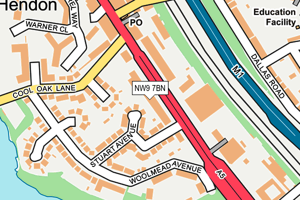
NW9 7BN is located in the West Hendon electoral ward, within the London borough of Barnet and the English Parliamentary constituency of Hendon. The Sub Integrated Care Board (ICB) Location is NHS North Central London ICB - 93C and the police force is Metropolitan Police. This postcode has been in use since June 2000.


GetTheData
Source: OS OpenMap – Local (Ordnance Survey)
Source: OS VectorMap District (Ordnance Survey)
Licence: Open Government Licence (requires attribution)
| Easting | 522218 |
| Northing | 187730 |
| Latitude | 51.575199 |
| Longitude | -0.237711 |
GetTheData
Source: Open Postcode Geo
Licence: Open Government Licence
| Country | England |
| Postcode District | NW9 |
| ➜ NW9 open data dashboard ➜ See where NW9 is on a map ➜ Where is Hendon? | |
GetTheData
Source: Land Registry Price Paid Data
Licence: Open Government Licence
Elevation or altitude of NW9 7BN as distance above sea level:
| Metres | Feet | |
|---|---|---|
| Elevation | 50m | 164ft |
Elevation is measured from the approximate centre of the postcode, to the nearest point on an OS contour line from OS Terrain 50, which has contour spacing of ten vertical metres.
➜ How high above sea level am I? Find the elevation of your current position using your device's GPS.
GetTheData
Source: Open Postcode Elevation
Licence: Open Government Licence
| Ward | West Hendon |
| Constituency | Hendon |
GetTheData
Source: ONS Postcode Database
Licence: Open Government Licence
| January 2024 | Violence and sexual offences | On or near Esmar Crescent | 96m |
| January 2024 | Violence and sexual offences | On or near Esmar Crescent | 96m |
| January 2024 | Violence and sexual offences | On or near Esmar Crescent | 96m |
| ➜ Get more crime data in our Crime section | |||
GetTheData
Source: data.police.uk
Licence: Open Government Licence
| Sutherland House (Broadway) | West Hendon | 89m |
| Park Road Broadway (Broadway) | West Hendon | 197m |
| Station Road Broadway (Broadway) | West Hendon | 227m |
| Priestley Way Broadway (Broadway) | West Hendon | 317m |
| West Hendon Broadway (Station Road) | West Hendon | 341m |
| Hendon Central Underground Station | Hendon Central | 1,195m |
| Hendon Station | 0.5km |
| Cricklewood Station | 2.5km |
| Wembley Stadium Station | 4km |
GetTheData
Source: NaPTAN
Licence: Open Government Licence
GetTheData
Source: ONS Postcode Database
Licence: Open Government Licence


➜ Get more ratings from the Food Standards Agency
GetTheData
Source: Food Standards Agency
Licence: FSA terms & conditions
| Last Collection | |||
|---|---|---|---|
| Location | Mon-Fri | Sat | Distance |
| The Hyde Post Office | 17:30 | 12:00 | 160m |
| Woolmead Avenue | 17:30 | 12:00 | 221m |
| Dartmouth Road | 17:30 | 12:00 | 308m |
GetTheData
Source: Dracos
Licence: Creative Commons Attribution-ShareAlike
| Facility | Distance |
|---|---|
| Princes Park Youth Football Club Cool Oak Lane, London Artificial Grass Pitch, Grass Pitches | 673m |
| The Gym Group (London Staples Corner) Geron Way, Cricklewood, London Health and Fitness Gym | 688m |
| West Hendon Playing Fields Goldsmith Avenue, Colindale, London Grass Pitches, Outdoor Tennis Courts | 882m |
GetTheData
Source: Active Places
Licence: Open Government Licence
| School | Phase of Education | Distance |
|---|---|---|
| Barnet Hill Academy 10a Montagu Road, Hendon, Hendon, London, NW4 3ES | Not applicable | 140m |
| Torah Vodaas Brent Park Road, West Hendon Broadway, London, NW9 7AJ | Not applicable | 339m |
| Parkfield Primary School St David's Place, Hendon, London, NW4 3PJ | Primary | 411m |
GetTheData
Source: Edubase
Licence: Open Government Licence
The below table lists the International Territorial Level (ITL) codes (formerly Nomenclature of Territorial Units for Statistics (NUTS) codes) and Local Administrative Units (LAU) codes for NW9 7BN:
| ITL 1 Code | Name |
|---|---|
| TLI | London |
| ITL 2 Code | Name |
| TLI7 | Outer London - West and North West |
| ITL 3 Code | Name |
| TLI71 | Barnet |
| LAU 1 Code | Name |
| E09000003 | Barnet |
GetTheData
Source: ONS Postcode Directory
Licence: Open Government Licence
The below table lists the Census Output Area (OA), Lower Layer Super Output Area (LSOA), and Middle Layer Super Output Area (MSOA) for NW9 7BN:
| Code | Name | |
|---|---|---|
| OA | E00001517 | |
| LSOA | E01000305 | Barnet 036B |
| MSOA | E02000059 | Barnet 036 |
GetTheData
Source: ONS Postcode Directory
Licence: Open Government Licence
| NW9 7AT | Stuart Avenue | 79m |
| NW9 7AA | West Hendon Broadway | 90m |
| NW9 7BL | Esmar Crescent | 104m |
| NW9 7AU | Stuart Avenue | 119m |
| NW9 7BJ | Cool Oak Lane | 133m |
| NW9 7BB | Seelig Avenue | 139m |
| NW9 7DY | West Hendon Broadway | 154m |
| NW9 7AX | Woolmead Avenue | 160m |
| NW9 7BA | Woolmead Avenue | 167m |
| NW9 7AW | Woolmead Avenue | 176m |
GetTheData
Source: Open Postcode Geo; Land Registry Price Paid Data
Licence: Open Government Licence