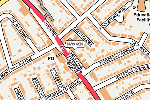
NW9 6SN is located in the Colindale South electoral ward, within the London borough of Barnet and the English Parliamentary constituency of Hendon. The Sub Integrated Care Board (ICB) Location is NHS North Central London ICB - 93C and the police force is Metropolitan Police. This postcode has been in use since January 1980.


GetTheData
Source: OS OpenMap – Local (Ordnance Survey)
Source: OS VectorMap District (Ordnance Survey)
Licence: Open Government Licence (requires attribution)
| Easting | 521251 |
| Northing | 189092 |
| Latitude | 51.587648 |
| Longitude | -0.251189 |
GetTheData
Source: Open Postcode Geo
Licence: Open Government Licence
| Country | England |
| Postcode District | NW9 |
| ➜ NW9 open data dashboard ➜ See where NW9 is on a map ➜ Where is London? | |
GetTheData
Source: Land Registry Price Paid Data
Licence: Open Government Licence
Elevation or altitude of NW9 6SN as distance above sea level:
| Metres | Feet | |
|---|---|---|
| Elevation | 50m | 164ft |
Elevation is measured from the approximate centre of the postcode, to the nearest point on an OS contour line from OS Terrain 50, which has contour spacing of ten vertical metres.
➜ How high above sea level am I? Find the elevation of your current position using your device's GPS.
GetTheData
Source: Open Postcode Elevation
Licence: Open Government Licence
| Ward | Colindale South |
| Constituency | Hendon |
GetTheData
Source: ONS Postcode Database
Licence: Open Government Licence
| June 2022 | Criminal damage and arson | On or near Edgware Road The Hyde | 37m |
| June 2022 | Theft from the person | On or near Edgware Road The Hyde | 37m |
| June 2022 | Violence and sexual offences | On or near Edgware Road The Hyde | 37m |
| ➜ Get more crime data in our Crime section | |||
GetTheData
Source: data.police.uk
Licence: Open Government Licence
| Sheaveshill Avenue (The Hyde) | The Hyde | 45m |
| Sheaveshill Avenue (The Hyde) | The Hyde | 70m |
| Kingsbury Road | The Hyde | 375m |
| Colindeep Lane (Edgware Road) | The Hyde | 375m |
| Edgware Road The Hyde | The Hyde | 417m |
| Colindale Underground Station | Colindale | 870m |
| Hendon Station | 1.2km |
| Mill Hill Broadway Station | 2.8km |
| Cricklewood Station | 4.2km |
GetTheData
Source: NaPTAN
Licence: Open Government Licence
GetTheData
Source: ONS Postcode Database
Licence: Open Government Licence


➜ Get more ratings from the Food Standards Agency
GetTheData
Source: Food Standards Agency
Licence: FSA terms & conditions
| Last Collection | |||
|---|---|---|---|
| Location | Mon-Fri | Sat | Distance |
| The Hyde Post Office | 17:30 | 12:00 | 40m |
| New Hay Road | 17:30 | 12:00 | 156m |
| Edgware Road | 17:30 | 12:00 | 272m |
GetTheData
Source: Dracos
Licence: Creative Commons Attribution-ShareAlike
| Facility | Distance |
|---|---|
| Colindale Primary School Clovelly Avenue, London Grass Pitches, Swimming Pool, Artificial Grass Pitch | 325m |
| Rushgrove Park Rushgrove Avenue, Colindale, London Outdoor Tennis Courts | 526m |
| The Gym Group (London Colindale) Zenith Close, London Health and Fitness Gym | 564m |
GetTheData
Source: Active Places
Licence: Open Government Licence
| School | Phase of Education | Distance |
|---|---|---|
| Colindale Primary School Clovelly Avenue, Colindale, London, NW9 6DT | Primary | 312m |
| The Hyde School Hyde Crescent, London, NW9 7EY | Primary | 603m |
| Beis Yaakov Primary School 373 Edgware Road, London, NW9 6NQ | Primary | 647m |
GetTheData
Source: Edubase
Licence: Open Government Licence
The below table lists the International Territorial Level (ITL) codes (formerly Nomenclature of Territorial Units for Statistics (NUTS) codes) and Local Administrative Units (LAU) codes for NW9 6SN:
| ITL 1 Code | Name |
|---|---|
| TLI | London |
| ITL 2 Code | Name |
| TLI7 | Outer London - West and North West |
| ITL 3 Code | Name |
| TLI71 | Barnet |
| LAU 1 Code | Name |
| E09000003 | Barnet |
GetTheData
Source: ONS Postcode Directory
Licence: Open Government Licence
The below table lists the Census Output Area (OA), Lower Layer Super Output Area (LSOA), and Middle Layer Super Output Area (MSOA) for NW9 6SN:
| Code | Name | |
|---|---|---|
| OA | E00000732 | |
| LSOA | E01033572 | Barnet 030E |
| MSOA | E02000053 | Barnet 030 |
GetTheData
Source: ONS Postcode Directory
Licence: Open Government Licence
| NW9 6RR | Varley Parade | 40m |
| NW9 6LP | Edgware Road | 62m |
| NW9 6RS | Sheaveshill Parade | 68m |
| NW9 6RT | Colin Close | 85m |
| NW9 6SH | Sheaveshill Avenue | 101m |
| NW9 6SG | Colin Parade | 111m |
| NW9 6RU | Sheaveshill Avenue | 115m |
| NW9 6PT | Woodfield Avenue | 117m |
| NW9 6SE | Sheaveshill Avenue | 122m |
| NW9 6PS | Woodfield Avenue | 126m |
GetTheData
Source: Open Postcode Geo; Land Registry Price Paid Data
Licence: Open Government Licence