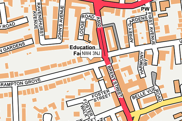
NW4 3NJ is located in the Hendon electoral ward, within the London borough of Barnet and the English Parliamentary constituency of Hendon. The Sub Integrated Care Board (ICB) Location is NHS North Central London ICB - 93C and the police force is Metropolitan Police. This postcode has been in use since July 1986.


GetTheData
Source: OS OpenMap – Local (Ordnance Survey)
Source: OS VectorMap District (Ordnance Survey)
Licence: Open Government Licence (requires attribution)
| Easting | 523278 |
| Northing | 189174 |
| Latitude | 51.587946 |
| Longitude | -0.221916 |
GetTheData
Source: Open Postcode Geo
Licence: Open Government Licence
| Country | England |
| Postcode District | NW4 |
| ➜ NW4 open data dashboard ➜ See where NW4 is on a map ➜ Where is Hendon? | |
GetTheData
Source: Land Registry Price Paid Data
Licence: Open Government Licence
Elevation or altitude of NW4 3NJ as distance above sea level:
| Metres | Feet | |
|---|---|---|
| Elevation | 80m | 262ft |
Elevation is measured from the approximate centre of the postcode, to the nearest point on an OS contour line from OS Terrain 50, which has contour spacing of ten vertical metres.
➜ How high above sea level am I? Find the elevation of your current position using your device's GPS.
GetTheData
Source: Open Postcode Elevation
Licence: Open Government Licence
| Ward | Hendon |
| Constituency | Hendon |
GetTheData
Source: ONS Postcode Database
Licence: Open Government Licence
| January 2024 | Anti-social behaviour | On or near Brampton Lane | 65m |
| January 2024 | Burglary | On or near Brampton Lane | 65m |
| January 2024 | Public order | On or near Brampton Lane | 65m |
| ➜ Get more crime data in our Crime section | |||
GetTheData
Source: data.police.uk
Licence: Open Government Licence
| The Quadrant Hendon (Brent Street) | Hendon | 120m |
| The Quadrant Hendon | Hendon | 155m |
| The Quadrant Hendon | Hendon | 191m |
| The Quadrant Hendon | Hendon | 207m |
| Bell Lane | Hendon | 231m |
| Hendon Central Underground Station | Hendon Central | 603m |
| Brent Cross Underground Station | Brent Cross | 1,382m |
| Hendon Station | 1.5km |
| Cricklewood Station | 3.3km |
| Mill Hill Broadway Station | 3.4km |
GetTheData
Source: NaPTAN
Licence: Open Government Licence
GetTheData
Source: ONS Postcode Database
Licence: Open Government Licence


➜ Get more ratings from the Food Standards Agency
GetTheData
Source: Food Standards Agency
Licence: FSA terms & conditions
| Last Collection | |||
|---|---|---|---|
| Location | Mon-Fri | Sat | Distance |
| Hendon Post Office | 18:00 | 12:00 | 24m |
| 200 Brent Street | 17:30 | 12:00 | 178m |
| 104 Brent Street | 17:30 | 12:00 | 226m |
GetTheData
Source: Dracos
Licence: Creative Commons Attribution-ShareAlike
| Facility | Distance |
|---|---|
| Nautilus Health Club Hendon (Closed) Victoria Road, London Health and Fitness Gym | 137m |
| Mr Fitta Health Club Sentinel Square, London Health and Fitness Gym | 157m |
| Hendon School Golders Rise, London Sports Hall, Grass Pitches | 378m |
GetTheData
Source: Active Places
Licence: Open Government Licence
| School | Phase of Education | Distance |
|---|---|---|
| Brampton College Lodge House, Lodge Road, Hendon, London, NW4 4DQ | Not applicable | 78m |
| Tiferes High School The Community Centre, 18 Raleigh Close, Hendon, London, NW4 2TA | Not applicable | 298m |
| Beth Jacob Grammar School for Girls Stratford Road, Hendon, London, NW4 2AT | Not applicable | 298m |
GetTheData
Source: Edubase
Licence: Open Government Licence
The below table lists the International Territorial Level (ITL) codes (formerly Nomenclature of Territorial Units for Statistics (NUTS) codes) and Local Administrative Units (LAU) codes for NW4 3NJ:
| ITL 1 Code | Name |
|---|---|
| TLI | London |
| ITL 2 Code | Name |
| TLI7 | Outer London - West and North West |
| ITL 3 Code | Name |
| TLI71 | Barnet |
| LAU 1 Code | Name |
| E09000003 | Barnet |
GetTheData
Source: ONS Postcode Directory
Licence: Open Government Licence
The below table lists the Census Output Area (OA), Lower Layer Super Output Area (LSOA), and Middle Layer Super Output Area (MSOA) for NW4 3NJ:
| Code | Name | |
|---|---|---|
| OA | E00001165 | |
| LSOA | E01000245 | Barnet 032E |
| MSOA | E02000055 | Barnet 032 |
GetTheData
Source: ONS Postcode Directory
Licence: Open Government Licence
| NW4 4ER | Chapel Walk | 69m |
| NW4 2DX | Brent Street | 78m |
| NW4 2RE | Brent Street | 80m |
| NW4 4AG | Brampton Grove | 89m |
| NW4 2DR | Brent Street | 100m |
| NW4 4EP | Somerset Road | 103m |
| NW4 2RF | Brent Street | 116m |
| NW4 4DG | Lodge Road | 122m |
| NW4 4DD | Lodge Road | 126m |
| NW4 4AE | Brampton Grove | 133m |
GetTheData
Source: Open Postcode Geo; Land Registry Price Paid Data
Licence: Open Government Licence