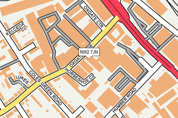
NW2 7JN lies on Oxgate Lane in London. NW2 7JN is located in the Dollis Hill electoral ward, within the London borough of Brent and the English Parliamentary constituency of Brent Central. The Sub Integrated Care Board (ICB) Location is NHS North West London ICB - W2U3Z and the police force is Metropolitan Police. This postcode has been in use since January 1980.


GetTheData
Source: OS OpenMap – Local (Ordnance Survey)
Source: OS VectorMap District (Ordnance Survey)
Licence: Open Government Licence (requires attribution)
| Easting | 522723 |
| Northing | 186850 |
| Latitude | 51.567181 |
| Longitude | -0.230735 |
GetTheData
Source: Open Postcode Geo
Licence: Open Government Licence
| Street | Oxgate Lane |
| Town/City | London |
| Country | England |
| Postcode District | NW2 |
| ➜ NW2 open data dashboard ➜ See where NW2 is on a map ➜ Where is London? | |
GetTheData
Source: Land Registry Price Paid Data
Licence: Open Government Licence
Elevation or altitude of NW2 7JN as distance above sea level:
| Metres | Feet | |
|---|---|---|
| Elevation | 50m | 164ft |
Elevation is measured from the approximate centre of the postcode, to the nearest point on an OS contour line from OS Terrain 50, which has contour spacing of ten vertical metres.
➜ How high above sea level am I? Find the elevation of your current position using your device's GPS.
GetTheData
Source: Open Postcode Elevation
Licence: Open Government Licence
| Ward | Dollis Hill |
| Constituency | Brent Central |
GetTheData
Source: ONS Postcode Database
Licence: Open Government Licence
| January 2024 | Public order | On or near Waterloo Road | 424m |
| January 2024 | Robbery | On or near Waterloo Road | 424m |
| November 2023 | Violence and sexual offences | On or near Waterloo Road | 424m |
| ➜ Oxgate Lane crime map and outcomes | |||
GetTheData
Source: data.police.uk
Licence: Open Government Licence
| Oxgate Lane | Dollis Hill | 89m |
| Oxgate Lane (Edgware Road) | Dollis Hill | 155m |
| Staples Corner Retail Park (Edgware Road) | West Hendon | 221m |
| Coles Green Road | Dollis Hill | 222m |
| Humber Road Dollis Hill | Dollis Hill | 237m |
| Brent Cross Underground Station | Brent Cross | 1,588m |
| Neasden Underground Station | Neasden | 1,976m |
| Hendon Station | 1.5km |
| Cricklewood Station | 1.6km |
| Brondesbury Station | 3.1km |
GetTheData
Source: NaPTAN
Licence: Open Government Licence
| Median download speed | 11.5Mbps |
| Average download speed | 11.9Mbps |
| Maximum download speed | 17.51Mbps |
| Median upload speed | 1.2Mbps |
| Average upload speed | 1.2Mbps |
| Maximum upload speed | 1.27Mbps |
GetTheData
Source: Ofcom
Licence: Ofcom Terms of Use (requires attribution)
GetTheData
Source: ONS Postcode Database
Licence: Open Government Licence
➜ Get more ratings from the Food Standards Agency
GetTheData
Source: Food Standards Agency
Licence: FSA terms & conditions
| Last Collection | |||
|---|---|---|---|
| Location | Mon-Fri | Sat | Distance |
| Oxgate Lane | 17:30 | 12:00 | 91m |
| Coles Green Road | 17:30 | 12:00 | 224m |
| Oxgate Court Post Office | 18:30 | 12:00 | 253m |
GetTheData
Source: Dracos
Licence: Creative Commons Attribution-ShareAlike
| Facility | Distance |
|---|---|
| The Gym Group (London Staples Corner) Geron Way, Cricklewood, London Health and Fitness Gym | 420m |
| Menorah High School For Girls Brook Road, London Sports Hall | 768m |
| Hendon Football Club (Closed) Claremont Road, London Grass Pitches | 903m |
GetTheData
Source: Active Places
Licence: Open Government Licence
| School | Phase of Education | Distance |
|---|---|---|
| Our Lady of Grace RC Infant and Nursery School Dollis Hill Avenue, London, NW2 6EU | Primary | 553m |
| Our Lady of Grace Catholic Junior School Dollis Hill Lane, London, NW2 6HS | Primary | 658m |
| Torah Vodaas Brent Park Road, West Hendon Broadway, London, NW9 7AJ | Not applicable | 732m |
GetTheData
Source: Edubase
Licence: Open Government Licence
The below table lists the International Territorial Level (ITL) codes (formerly Nomenclature of Territorial Units for Statistics (NUTS) codes) and Local Administrative Units (LAU) codes for NW2 7JN:
| ITL 1 Code | Name |
|---|---|
| TLI | London |
| ITL 2 Code | Name |
| TLI7 | Outer London - West and North West |
| ITL 3 Code | Name |
| TLI72 | Brent |
| LAU 1 Code | Name |
| E09000005 | Brent |
GetTheData
Source: ONS Postcode Directory
Licence: Open Government Licence
The below table lists the Census Output Area (OA), Lower Layer Super Output Area (LSOA), and Middle Layer Super Output Area (MSOA) for NW2 7JN:
| Code | Name | |
|---|---|---|
| OA | E00002438 | |
| LSOA | E01000497 | Brent 011A |
| MSOA | E02000103 | Brent 011 |
GetTheData
Source: ONS Postcode Directory
Licence: Open Government Licence
| NW2 7JJ | Horseshoe Close | 49m |
| NW2 7JG | Oxgate Lane | 139m |
| NW2 6EW | Edge Business Centre | 146m |
| NW2 6DW | Humber Trading Estate | 152m |
| NW2 7JH | Coles Green Road | 162m |
| NW2 6EN | Humber Road | 184m |
| NW2 7BX | Crest Road | 200m |
| NW2 6EH | Humber Road | 205m |
| NW2 6EE | Coles Green Road | 208m |
| NW2 7ES | Coles Green Road | 220m |
GetTheData
Source: Open Postcode Geo; Land Registry Price Paid Data
Licence: Open Government Licence