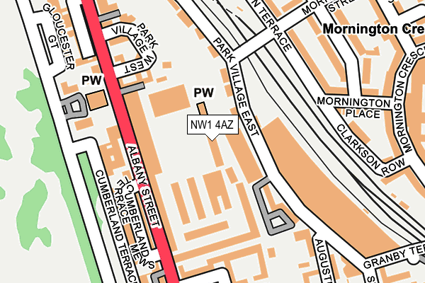
NW1 4AZ is located in the Regent's Park electoral ward, within the London borough of Camden and the English Parliamentary constituency of Holborn and St Pancras. The Sub Integrated Care Board (ICB) Location is NHS North Central London ICB - 93C and the police force is Metropolitan Police. This postcode has been in use since June 2002.


GetTheData
Source: OS OpenMap – Local (Ordnance Survey)
Source: OS VectorMap District (Ordnance Survey)
Licence: Open Government Licence (requires attribution)
| Easting | 528724 |
| Northing | 183178 |
| Latitude | 51.532844 |
| Longitude | -0.145543 |
GetTheData
Source: Open Postcode Geo
Licence: Open Government Licence
| Country | England |
| Postcode District | NW1 |
| ➜ NW1 open data dashboard ➜ See where NW1 is on a map ➜ Where is London? | |
GetTheData
Source: Land Registry Price Paid Data
Licence: Open Government Licence
Elevation or altitude of NW1 4AZ as distance above sea level:
| Metres | Feet | |
|---|---|---|
| Elevation | 30m | 98ft |
Elevation is measured from the approximate centre of the postcode, to the nearest point on an OS contour line from OS Terrain 50, which has contour spacing of ten vertical metres.
➜ How high above sea level am I? Find the elevation of your current position using your device's GPS.
GetTheData
Source: Open Postcode Elevation
Licence: Open Government Licence
| Ward | Regent's Park |
| Constituency | Holborn And St Pancras |
GetTheData
Source: ONS Postcode Database
Licence: Open Government Licence
| January 2024 | Other theft | On or near Symes Mews | 495m |
| January 2024 | Robbery | On or near Symes Mews | 495m |
| January 2024 | Shoplifting | On or near Symes Mews | 495m |
| ➜ Get more crime data in our Crime section | |||
GetTheData
Source: data.police.uk
Licence: Open Government Licence
| Regent's Park Barracks (Albany Street) | Regent's Park | 59m |
| Cumberland Terrace (Albany Street) | Regent's Park | 139m |
| Regent's Park Barracks (Albany Street) | Regent's Park | 189m |
| Prince Albert Rd London Zoo (Albany Street) | Regent's Park | 209m |
| Cumberland Terrace (Albany Street) | Regent's Park | 213m |
| Mornington Crescent Underground Station | Mornington Crescent | 513m |
| Camden Town Underground Station | Camden Town | 744m |
| Euston Underground Station | Euston | 979m |
| Great Portland Street Underground Station | Great Portland Street | 1,006m |
| Warren Street Underground Station | Warren Street | 1,012m |
| London Euston Station | 1km |
| Camden Road Station | 1.1km |
| London St Pancras International LL Station | 1.3km |
GetTheData
Source: NaPTAN
Licence: Open Government Licence
GetTheData
Source: ONS Postcode Database
Licence: Open Government Licence


➜ Get more ratings from the Food Standards Agency
GetTheData
Source: Food Standards Agency
Licence: FSA terms & conditions
| Last Collection | |||
|---|---|---|---|
| Location | Mon-Fri | Sat | Distance |
| 10 Cumberland Terrace | 19:00 | 13:00 | 81m |
| 204 Albany Street | 19:00 | 13:00 | 244m |
| Mornington | 19:00 | 13:00 | 274m |
GetTheData
Source: Dracos
Licence: Creative Commons Attribution-ShareAlike
| Facility | Distance |
|---|---|
| Kieser Training (Closed) Hampstead Road, London Health and Fitness Gym | 418m |
| North Bridge House Prep School (Closed) Gloucester Avenue, London Sports Hall | 431m |
| Fitness First (Camden) (Closed) Albert Street, London Health and Fitness Gym, Studio | 555m |
GetTheData
Source: Active Places
Licence: Open Government Licence
| School | Phase of Education | Distance |
|---|---|---|
| Christ Church School Redhill Street, Camden, London, NW1 4BD | Primary | 211m |
| North Bridge House Preparatory 1 Gloucester Avenue, London, NW1 7AB | Not applicable | 431m |
| Camden Primary Pupil Referral Unit Robson House, Netley Campus, 74 Stanhope Street, London, NW1 3EX | Not applicable | 665m |
GetTheData
Source: Edubase
Licence: Open Government Licence
The below table lists the International Territorial Level (ITL) codes (formerly Nomenclature of Territorial Units for Statistics (NUTS) codes) and Local Administrative Units (LAU) codes for NW1 4AZ:
| ITL 1 Code | Name |
|---|---|
| TLI | London |
| ITL 2 Code | Name |
| TLI3 | Inner London - West |
| ITL 3 Code | Name |
| TLI31 | Camden and City of London |
| LAU 1 Code | Name |
| E09000007 | Camden |
GetTheData
Source: ONS Postcode Directory
Licence: Open Government Licence
The below table lists the Census Output Area (OA), Lower Layer Super Output Area (LSOA), and Middle Layer Super Output Area (MSOA) for NW1 4AZ:
| Code | Name | |
|---|---|---|
| OA | E00004714 | |
| LSOA | E01000946 | Camden 021B |
| MSOA | E02000186 | Camden 021 |
GetTheData
Source: ONS Postcode Directory
Licence: Open Government Licence
| NW1 4HT | Cumberland Terrace Mews | 41m |
| NW1 4HR | Cumberland Terrace Mews | 65m |
| NW1 4HJ | Cumberland Terrace | 66m |
| NW1 4HP | Cumberland Terrace | 81m |
| NW1 7QH | Park Village East | 121m |
| NW1 4AP | Albany Street | 126m |
| NW1 4HH | St Katharines Precinct | 162m |
| NW1 4HN | Cumberland Terrace Mews | 163m |
| NW1 4AE | Park Village West | 165m |
| NW1 4AU | Unit 8 | 169m |
GetTheData
Source: Open Postcode Geo; Land Registry Price Paid Data
Licence: Open Government Licence