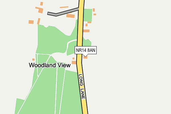
NR14 8AN lies on Long Lane in Bracon Ash, Norwich. NR14 8AN is located in the Mulbarton & Stoke Holy Cross electoral ward, within the local authority district of South Norfolk and the English Parliamentary constituency of South Norfolk. The Sub Integrated Care Board (ICB) Location is NHS Norfolk and Waveney ICB - 26A and the police force is Norfolk. This postcode has been in use since January 1980.


GetTheData
Source: OS OpenMap – Local (Ordnance Survey)
Source: OS VectorMap District (Ordnance Survey)
Licence: Open Government Licence (requires attribution)
| Easting | 619522 |
| Northing | 299284 |
| Latitude | 52.547118 |
| Longitude | 1.236208 |
GetTheData
Source: Open Postcode Geo
Licence: Open Government Licence
| Street | Long Lane |
| Locality | Bracon Ash |
| Town/City | Norwich |
| Country | England |
| Postcode District | NR14 |
| ➜ NR14 open data dashboard ➜ See where NR14 is on a map | |
GetTheData
Source: Land Registry Price Paid Data
Licence: Open Government Licence
Elevation or altitude of NR14 8AN as distance above sea level:
| Metres | Feet | |
|---|---|---|
| Elevation | 50m | 164ft |
Elevation is measured from the approximate centre of the postcode, to the nearest point on an OS contour line from OS Terrain 50, which has contour spacing of ten vertical metres.
➜ How high above sea level am I? Find the elevation of your current position using your device's GPS.
GetTheData
Source: Open Postcode Elevation
Licence: Open Government Licence
| Ward | Mulbarton & Stoke Holy Cross |
| Constituency | South Norfolk |
GetTheData
Source: ONS Postcode Database
Licence: Open Government Licence
| Birchfield Lane (Cuckoofield Lane) | Mulbarton | 955m |
| Birchfield Lane (Cuckoofield Lane) | Mulbarton | 966m |
| Birchfield Gardens (Long Lane) | Mulbarton | 1,101m |
| Bluebell Road (Long Lane) | Mulbarton | 1,101m |
| Lark Rise (Cuckoofield Lane) | Mulbarton | 1,141m |
GetTheData
Source: NaPTAN
Licence: Open Government Licence
➜ Broadband speed and availability dashboard for NR14 8AN
| Percentage of properties with Next Generation Access | 100.0% |
| Percentage of properties with Superfast Broadband | 71.4% |
| Percentage of properties with Ultrafast Broadband | 0.0% |
| Percentage of properties with Full Fibre Broadband | 0.0% |
Superfast Broadband is between 30Mbps and 300Mbps
Ultrafast Broadband is > 300Mbps
| Median download speed | 23.9Mbps |
| Average download speed | 21.0Mbps |
| Maximum download speed | 34.18Mbps |
| Median upload speed | 6.5Mbps |
| Average upload speed | 5.6Mbps |
| Maximum upload speed | 7.63Mbps |
| Percentage of properties unable to receive 2Mbps | 0.0% |
| Percentage of properties unable to receive 5Mbps | 0.0% |
| Percentage of properties unable to receive 10Mbps | 0.0% |
| Percentage of properties unable to receive 30Mbps | 28.6% |
➜ Broadband speed and availability dashboard for NR14 8AN
GetTheData
Source: Ofcom
Licence: Ofcom Terms of Use (requires attribution)
GetTheData
Source: ONS Postcode Database
Licence: Open Government Licence


➜ Get more ratings from the Food Standards Agency
GetTheData
Source: Food Standards Agency
Licence: FSA terms & conditions
| Last Collection | |||
|---|---|---|---|
| Location | Mon-Fri | Sat | Distance |
| Cuckoofield Lane | 16:30 | 09:30 | 983m |
| Birchfield Lane Post Office | 17:15 | 11:45 | 1,333m |
| Main Road | 15:45 | 07:30 | 1,438m |
GetTheData
Source: Dracos
Licence: Creative Commons Attribution-ShareAlike
| Facility | Distance |
|---|---|
| Alan King Playing Fields Grove Way, Newton Flotman Grass Pitches | 1.5km |
| Mulbarton Common The Common, Mulbarton, Norwich Grass Pitches | 1.6km |
| Mulbarton Cricket Club (Orchard Park) (Closed) The Common, Mulbarton, Norwich Grass Pitches | 1.7km |
GetTheData
Source: Active Places
Licence: Open Government Licence
| School | Phase of Education | Distance |
|---|---|---|
| Mulbarton Primary School The Common, Mulbarton, Norwich, NR14 8JG | Primary | 1.4km |
| Newton Flotman Church of England Primary Academy School Road, Newton Flotman, Norwich, NR15 1PR | Primary | 1.8km |
| Hapton Church of England Voluntary Aided Primary School The Street, Hapton, Norwich, NR15 1AD | Primary | 3.4km |
GetTheData
Source: Edubase
Licence: Open Government Licence
The below table lists the International Territorial Level (ITL) codes (formerly Nomenclature of Territorial Units for Statistics (NUTS) codes) and Local Administrative Units (LAU) codes for NR14 8AN:
| ITL 1 Code | Name |
|---|---|
| TLH | East |
| ITL 2 Code | Name |
| TLH1 | East Anglia |
| ITL 3 Code | Name |
| TLH17 | Breckland and South Norfolk |
| LAU 1 Code | Name |
| E07000149 | South Norfolk |
GetTheData
Source: ONS Postcode Directory
Licence: Open Government Licence
The below table lists the Census Output Area (OA), Lower Layer Super Output Area (LSOA), and Middle Layer Super Output Area (MSOA) for NR14 8AN:
| Code | Name | |
|---|---|---|
| OA | E00136890 | |
| LSOA | E01026913 | South Norfolk 009A |
| MSOA | E02005605 | South Norfolk 009 |
GetTheData
Source: ONS Postcode Directory
Licence: Open Government Licence
| NR14 8GX | Meadows Drive | 591m |
| NR14 8EH | 644m | |
| NR14 8GP | Sowdlefield Walk | 645m |
| NR14 8GU | Oatfield Chase | 689m |
| NR14 8GQ | Cornfield Road | 717m |
| NR14 8GZ | Bromedale Avenue | 762m |
| NR14 8GN | Chappshill Way | 779m |
| NR14 8FD | Ryefield Road | 798m |
| NR14 8GT | Wheatfield Road | 798m |
| NR14 8GG | Bromedale Avenue | 809m |
GetTheData
Source: Open Postcode Geo; Land Registry Price Paid Data
Licence: Open Government Licence