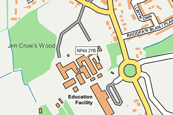
NP44 2YB is located in the Croesyceiliog electoral ward, within the unitary authority of Torfaen and the Welsh Parliamentary constituency of Monmouth. The Local Health Board is Aneurin Bevan University and the police force is Gwent. This postcode has been in use since January 1980.


GetTheData
Source: OS OpenMap – Local (Ordnance Survey)
Source: OS VectorMap District (Ordnance Survey)
Licence: Open Government Licence (requires attribution)
| Easting | 330489 |
| Northing | 195658 |
| Latitude | 51.655396 |
| Longitude | -3.006224 |
GetTheData
Source: Open Postcode Geo
Licence: Open Government Licence
| Country | Wales |
| Postcode District | NP44 |
| ➜ NP44 open data dashboard ➜ See where NP44 is on a map ➜ Where is Cwmbrân? | |
GetTheData
Source: Land Registry Price Paid Data
Licence: Open Government Licence
Elevation or altitude of NP44 2YB as distance above sea level:
| Metres | Feet | |
|---|---|---|
| Elevation | 70m | 230ft |
Elevation is measured from the approximate centre of the postcode, to the nearest point on an OS contour line from OS Terrain 50, which has contour spacing of ten vertical metres.
➜ How high above sea level am I? Find the elevation of your current position using your device's GPS.
GetTheData
Source: Open Postcode Elevation
Licence: Open Government Licence
| Ward | Croesyceiliog |
| Constituency | Monmouth |
GetTheData
Source: ONS Postcode Database
Licence: Open Government Licence
| January 2024 | Vehicle crime | On or near Tewdric Court | 485m |
| January 2024 | Vehicle crime | On or near Tewdric Court | 485m |
| November 2023 | Violence and sexual offences | On or near Tewdric Court | 485m |
| ➜ Get more crime data in our Crime section | |||
GetTheData
Source: data.police.uk
Licence: Open Government Licence
| Christophers Garage (Woodland Road) | Croesyceiliog | 93m |
| Comprehensive School (Grounds) | Croesyceiliog | 101m |
| Plantation Drive (Turnpike Road) | Croesyceiliog | 103m |
| Christophers Garage (Woodland Road) | Croesyceiliog | 107m |
| Plantation Drive (Turnpike Road) | Croesyceiliog | 132m |
| Cwmbran Station | 0.7km |
| Pontypool & New Inn Station | 4.8km |
GetTheData
Source: NaPTAN
Licence: Open Government Licence
GetTheData
Source: ONS Postcode Database
Licence: Open Government Licence


➜ Get more ratings from the Food Standards Agency
GetTheData
Source: Food Standards Agency
Licence: FSA terms & conditions
| Last Collection | |||
|---|---|---|---|
| Location | Mon-Fri | Sat | Distance |
| North Road | 17:30 | 11:00 | 816m |
| Edlogan Square Post Office | 17:00 | 12:00 | 988m |
| Radnor Way | 17:30 | 11:00 | 1,264m |
GetTheData
Source: Dracos
Licence: Creative Commons Attribution-ShareAlike
| School | Phase of Education | Distance |
|---|---|---|
| Croesyceiliog School Woodland Road, Croesyceiliog, Cwmbran, Torfaen, NP44 2YB | Not applicable | 77m |
| Crownbridge Special Day School Turnpike Road, Croesyceiliog, Cwmbran, Torfaen, NP44 2BJ | Not applicable | 185m |
| Llanyrafon Primary School Llanyrafon Way, Llanyrafon, Cwmbran, Torfaen, NP44 8HW | Not applicable | 715m |
GetTheData
Source: Edubase
Licence: Open Government Licence
The below table lists the International Territorial Level (ITL) codes (formerly Nomenclature of Territorial Units for Statistics (NUTS) codes) and Local Administrative Units (LAU) codes for NP44 2YB:
| ITL 1 Code | Name |
|---|---|
| TLL | Wales |
| ITL 2 Code | Name |
| TLL1 | West Wales and The Valleys |
| ITL 3 Code | Name |
| TLL16 | Gwent Valleys |
| LAU 1 Code | Name |
| W06000020 | Torfaen |
GetTheData
Source: ONS Postcode Directory
Licence: Open Government Licence
The below table lists the Census Output Area (OA), Lower Layer Super Output Area (LSOA), and Middle Layer Super Output Area (MSOA) for NP44 2YB:
| Code | Name | |
|---|---|---|
| OA | W00007812 | |
| LSOA | W01001495 | Torfaen 008C |
| MSOA | W02000330 | Torfaen 008 |
GetTheData
Source: ONS Postcode Directory
Licence: Open Government Licence
| NP44 2DX | Woodland Road | 115m |
| NP44 2AH | Turnpike Road | 133m |
| NP44 2EA | Plas Derwen | 176m |
| NP44 2HH | Jim Crow Square | 191m |
| NP44 2AL | Llwyn Onn | 210m |
| NP44 2BG | The Highway | 218m |
| NP44 2EE | Cwrt Glas | 242m |
| NP44 2AP | 244m | |
| NP44 2AN | Plantation Drive | 264m |
| NP44 2BH | Ashford Close South | 268m |
GetTheData
Source: Open Postcode Geo; Land Registry Price Paid Data
Licence: Open Government Licence