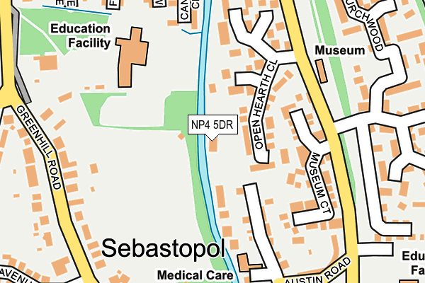
NP4 5DR is in Sebastopol, Pontypool. NP4 5DR is located in the Panteg electoral ward, within the unitary authority of Torfaen and the Welsh Parliamentary constituency of Torfaen. The Local Health Board is Aneurin Bevan University and the police force is Gwent. This postcode has been in use since January 1980.


GetTheData
Source: OS OpenMap – Local (Ordnance Survey)
Source: OS VectorMap District (Ordnance Survey)
Licence: Open Government Licence (requires attribution)
| Easting | 329348 |
| Northing | 198596 |
| Latitude | 51.681663 |
| Longitude | -3.023303 |
GetTheData
Source: Open Postcode Geo
Licence: Open Government Licence
| Locality | Sebastopol |
| Town/City | Pontypool |
| Country | Wales |
| Postcode District | NP4 |
| ➜ NP4 open data dashboard ➜ See where NP4 is on a map ➜ Where is Pontypool? | |
GetTheData
Source: Land Registry Price Paid Data
Licence: Open Government Licence
Elevation or altitude of NP4 5DR as distance above sea level:
| Metres | Feet | |
|---|---|---|
| Elevation | 110m | 361ft |
Elevation is measured from the approximate centre of the postcode, to the nearest point on an OS contour line from OS Terrain 50, which has contour spacing of ten vertical metres.
➜ How high above sea level am I? Find the elevation of your current position using your device's GPS.
GetTheData
Source: Open Postcode Elevation
Licence: Open Government Licence
| Ward | Panteg |
| Constituency | Torfaen |
GetTheData
Source: ONS Postcode Database
Licence: Open Government Licence
THE OPEN HEARTH, SEBASTOPOL, PONTYPOOL, NP4 5DR 1998 15 SEP £90,799 |
GetTheData
Source: HM Land Registry Price Paid Data
Licence: Contains HM Land Registry data © Crown copyright and database right 2024. This data is licensed under the Open Government Licence v3.0.
| December 2023 | Violence and sexual offences | On or near Museum Court | 145m |
| December 2023 | Violence and sexual offences | On or near Museum Court | 145m |
| June 2023 | Burglary | On or near Museum Court | 145m |
| ➜ Get more crime data in our Crime section | |||
GetTheData
Source: data.police.uk
Licence: Open Government Licence
| Giffithstown Rly Museum (Station Road) | Griffithstown | 155m |
| Giffithstown Rly Museum (Station Road) | Griffithstown | 164m |
| Greenhill Road Middle (Greenhill Road) | Sebastopol | 250m |
| Greenhill Road Middle (Greenhill Road) | Sebastopol | 259m |
| Panteg Steelworks (Station Road) | Sebastopol | 308m |
| Pontypool & New Inn Station | 1.9km |
| Cwmbran Station | 2.8km |
GetTheData
Source: NaPTAN
Licence: Open Government Licence
GetTheData
Source: ONS Postcode Database
Licence: Open Government Licence


➜ Get more ratings from the Food Standards Agency
GetTheData
Source: Food Standards Agency
Licence: FSA terms & conditions
| Last Collection | |||
|---|---|---|---|
| Location | Mon-Fri | Sat | Distance |
| Hawthorn Road | 16:15 | 11:45 | 633m |
| Five Locks Close | 17:30 | 11:00 | 1,944m |
| Edlogan Square Post Office | 17:00 | 12:00 | 2,167m |
GetTheData
Source: Dracos
Licence: Creative Commons Attribution-ShareAlike
| School | Phase of Education | Distance |
|---|---|---|
| Griffithstown Primary Florence Place, Griffithstown, Pontypool, NP4 5DN | Not applicable | 181m |
| New Inn Primary School Off Golf Road, New Inn, Pontypool, Torfaen, NP4 0PR | Not applicable | 1.6km |
| West Monmouth Comprehensive School Blaendare Road, Pontypool, Torfaen, NP4 5YG | Not applicable | 1.9km |
GetTheData
Source: Edubase
Licence: Open Government Licence
The below table lists the International Territorial Level (ITL) codes (formerly Nomenclature of Territorial Units for Statistics (NUTS) codes) and Local Administrative Units (LAU) codes for NP4 5DR:
| ITL 1 Code | Name |
|---|---|
| TLL | Wales |
| ITL 2 Code | Name |
| TLL1 | West Wales and The Valleys |
| ITL 3 Code | Name |
| TLL16 | Gwent Valleys |
| LAU 1 Code | Name |
| W06000020 | Torfaen |
GetTheData
Source: ONS Postcode Directory
Licence: Open Government Licence
The below table lists the Census Output Area (OA), Lower Layer Super Output Area (LSOA), and Middle Layer Super Output Area (MSOA) for NP4 5DR:
| Code | Name | |
|---|---|---|
| OA | W00007912 | |
| LSOA | W01001517 | Torfaen 006D |
| MSOA | W02000328 | Torfaen 006 |
GetTheData
Source: ONS Postcode Directory
Licence: Open Government Licence
| NP4 5JR | Open Hearth Close | 84m |
| NP4 5DT | Wern Road | 122m |
| NP4 5GZ | Museum Court | 144m |
| NP4 5LU | Open Hearth Close | 173m |
| NP4 5BG | Greenhill Road | 213m |
| NP4 5ER | Austin Road | 238m |
| NP4 5DW | East View | 242m |
| NP4 5DN | Florence Place | 259m |
| NP4 5SX | Churchwood | 264m |
| NP4 5BH | Greenhill Road | 273m |
GetTheData
Source: Open Postcode Geo; Land Registry Price Paid Data
Licence: Open Government Licence