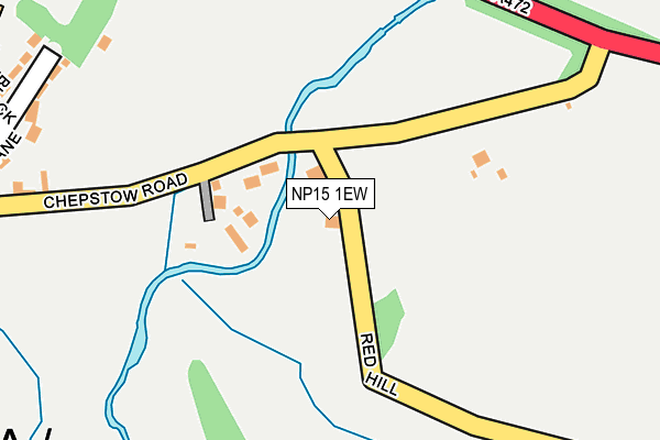
NP15 1EW is located in the Llangybi Fawr electoral ward, within the unitary authority of Monmouthshire and the Welsh Parliamentary constituency of Monmouth. The Local Health Board is Aneurin Bevan University and the police force is Gwent. This postcode has been in use since June 1999.


GetTheData
Source: OS OpenMap – Local (Ordnance Survey)
Source: OS VectorMap District (Ordnance Survey)
Licence: Open Government Licence (requires attribution)
| Easting | 338424 |
| Northing | 200909 |
| Latitude | 51.703527 |
| Longitude | -2.892456 |
GetTheData
Source: Open Postcode Geo
Licence: Open Government Licence
| Country | Wales |
| Postcode District | NP15 |
| ➜ NP15 open data dashboard ➜ See where NP15 is on a map ➜ Where is Usk? | |
GetTheData
Source: Land Registry Price Paid Data
Licence: Open Government Licence
Elevation or altitude of NP15 1EW as distance above sea level:
| Metres | Feet | |
|---|---|---|
| Elevation | 20m | 66ft |
Elevation is measured from the approximate centre of the postcode, to the nearest point on an OS contour line from OS Terrain 50, which has contour spacing of ten vertical metres.
➜ How high above sea level am I? Find the elevation of your current position using your device's GPS.
GetTheData
Source: Open Postcode Elevation
Licence: Open Government Licence
| Ward | Llangybi Fawr |
| Constituency | Monmouth |
GetTheData
Source: ONS Postcode Database
Licence: Open Government Licence
| May 2022 | Violence and sexual offences | On or near The Meadows | 410m |
| January 2022 | Vehicle crime | On or near St Mary'S Way | 449m |
| December 2021 | Drugs | On or near Blackfriars | 454m |
| ➜ Get more crime data in our Crime section | |||
GetTheData
Source: data.police.uk
Licence: Open Government Licence
| Olway Bridge (Chepstow Road) | Usk | 71m |
| Olway Bridge (Chepstow Road) | Usk | 75m |
| Greyhound Inn (Chepstow Road) | Usk | 332m |
| Greyhound Inn (Chepstow Road) | Usk | 335m |
| Ladyhill (Monmouth Road) | Usk | 424m |
GetTheData
Source: NaPTAN
Licence: Open Government Licence
| Percentage of properties with Next Generation Access | 100.0% |
| Percentage of properties with Superfast Broadband | 100.0% |
| Percentage of properties with Ultrafast Broadband | 0.0% |
| Percentage of properties with Full Fibre Broadband | 0.0% |
Superfast Broadband is between 30Mbps and 300Mbps
Ultrafast Broadband is > 300Mbps
| Percentage of properties unable to receive 2Mbps | 0.0% |
| Percentage of properties unable to receive 5Mbps | 0.0% |
| Percentage of properties unable to receive 10Mbps | 0.0% |
| Percentage of properties unable to receive 30Mbps | 0.0% |
GetTheData
Source: Ofcom
Licence: Ofcom Terms of Use (requires attribution)
GetTheData
Source: ONS Postcode Database
Licence: Open Government Licence


➜ Get more ratings from the Food Standards Agency
GetTheData
Source: Food Standards Agency
Licence: FSA terms & conditions
| Last Collection | |||
|---|---|---|---|
| Location | Mon-Fri | Sat | Distance |
| Lady Hill | 17:30 | 11:30 | 445m |
| Castle Parade | 17:30 | 11:30 | 623m |
| Maryport | 17:30 | 11:30 | 726m |
GetTheData
Source: Dracos
Licence: Creative Commons Attribution-ShareAlike
| School | Phase of Education | Distance |
|---|---|---|
| Usk C.V.. Primary School Monmouth Road, Usk, Monmouthshire, NP15 1SE | Not applicable | 522m |
GetTheData
Source: Edubase
Licence: Open Government Licence
The below table lists the International Territorial Level (ITL) codes (formerly Nomenclature of Territorial Units for Statistics (NUTS) codes) and Local Administrative Units (LAU) codes for NP15 1EW:
| ITL 1 Code | Name |
|---|---|
| TLL | Wales |
| ITL 2 Code | Name |
| TLL2 | East Wales |
| ITL 3 Code | Name |
| TLL21 | Monmouthshire and Newport |
| LAU 1 Code | Name |
| W06000021 | Monmouthshire |
GetTheData
Source: ONS Postcode Directory
Licence: Open Government Licence
The below table lists the Census Output Area (OA), Lower Layer Super Output Area (LSOA), and Middle Layer Super Output Area (MSOA) for NP15 1EW:
| Code | Name | |
|---|---|---|
| OA | W00008160 | |
| LSOA | W01001565 | Monmouthshire 006D |
| MSOA | W02000341 | Monmouthshire 006 |
GetTheData
Source: ONS Postcode Directory
Licence: Open Government Licence
| NP15 1HN | Chepstow Road | 78m |
| NP15 1BL | Chepstow Road | 309m |
| NP15 1BP | Blackbarn Lane | 323m |
| NP15 1BS | Blackbarn Close | 350m |
| NP15 1GZ | Blackbarn Mews | 363m |
| NP15 1QN | Cwrt Bryn Derwen | 386m |
| NP15 1BT | The Meadows | 418m |
| NP15 1BE | Four Ash Court | 443m |
| NP15 1SF | Monmouth Road | 446m |
| NP15 1BX | St Marys Way | 456m |
GetTheData
Source: Open Postcode Geo; Land Registry Price Paid Data
Licence: Open Government Licence