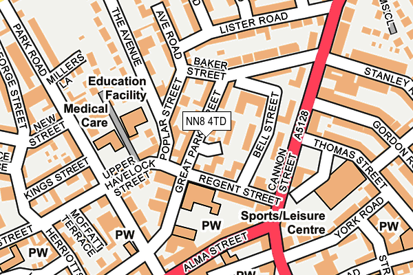
NN8 4TD is located in the Croyland and Swanspool electoral ward, within the unitary authority of North Northamptonshire and the English Parliamentary constituency of Wellingborough. The Sub Integrated Care Board (ICB) Location is NHS Northamptonshire ICB - 78H and the police force is Northamptonshire. This postcode has been in use since June 1999.


GetTheData
Source: OS OpenMap – Local (Ordnance Survey)
Source: OS VectorMap District (Ordnance Survey)
Licence: Open Government Licence (requires attribution)
| Easting | 489335 |
| Northing | 268283 |
| Latitude | 52.305422 |
| Longitude | -0.691179 |
GetTheData
Source: Open Postcode Geo
Licence: Open Government Licence
| Country | England |
| Postcode District | NN8 |
| ➜ NN8 open data dashboard ➜ See where NN8 is on a map ➜ Where is Wellingborough? | |
GetTheData
Source: Land Registry Price Paid Data
Licence: Open Government Licence
Elevation or altitude of NN8 4TD as distance above sea level:
| Metres | Feet | |
|---|---|---|
| Elevation | 70m | 230ft |
Elevation is measured from the approximate centre of the postcode, to the nearest point on an OS contour line from OS Terrain 50, which has contour spacing of ten vertical metres.
➜ How high above sea level am I? Find the elevation of your current position using your device's GPS.
GetTheData
Source: Open Postcode Elevation
Licence: Open Government Licence
| Ward | Croyland And Swanspool |
| Constituency | Wellingborough |
GetTheData
Source: ONS Postcode Database
Licence: Open Government Licence
| January 2024 | Criminal damage and arson | On or near Gordon Road | 298m |
| January 2024 | Vehicle crime | On or near Gordon Road | 298m |
| January 2024 | Violence and sexual offences | On or near Gordon Road | 298m |
| ➜ Get more crime data in our Crime section | |||
GetTheData
Source: data.police.uk
Licence: Open Government Licence
| Cambridge Street (Cannon Street) | Wellingborough | 244m |
| Park Mews (Park Road) | Wellingborough | 280m |
| Church Street Interchange (Church Street) | Wellingborough | 300m |
| Health Centre (Gold Street) | Wellingborough | 322m |
| Baptist Church (Mill Road) | Wellingborough | 323m |
| Wellingborough Station | 1km |
GetTheData
Source: NaPTAN
Licence: Open Government Licence
| Percentage of properties with Next Generation Access | 100.0% |
| Percentage of properties with Superfast Broadband | 100.0% |
| Percentage of properties with Ultrafast Broadband | 0.0% |
| Percentage of properties with Full Fibre Broadband | 0.0% |
Superfast Broadband is between 30Mbps and 300Mbps
Ultrafast Broadband is > 300Mbps
| Percentage of properties unable to receive 2Mbps | 0.0% |
| Percentage of properties unable to receive 5Mbps | 0.0% |
| Percentage of properties unable to receive 10Mbps | 0.0% |
| Percentage of properties unable to receive 30Mbps | 0.0% |
GetTheData
Source: Ofcom
Licence: Ofcom Terms of Use (requires attribution)
GetTheData
Source: ONS Postcode Database
Licence: Open Government Licence


➜ Get more ratings from the Food Standards Agency
GetTheData
Source: Food Standards Agency
Licence: FSA terms & conditions
| Last Collection | |||
|---|---|---|---|
| Location | Mon-Fri | Sat | Distance |
| Park Cres | 17:15 | 11:00 | 74m |
| Gloucester Place | 16:45 | 11:00 | 287m |
| Midland Road | 18:30 | 395m | |
GetTheData
Source: Dracos
Licence: Creative Commons Attribution-ShareAlike
| Facility | Distance |
|---|---|
| The Old Drill Hall Great Park Street, Wellingborough Sports Hall | 116m |
| Wellingborough Working Mens Club (Closed) Park Crescent, Wellingborough Sports Hall | 198m |
| Waendel Leisure Centre Thomas Street, Wellingborough Swimming Pool, Health and Fitness Gym, Studio | 204m |
GetTheData
Source: Active Places
Licence: Open Government Licence
| School | Phase of Education | Distance |
|---|---|---|
| Park Junior School, Wellingborough Great Park Street, Wellingborough, NN8 4PH | Primary | 88m |
| The Avenue Infant School The Avenue, Wellingborough, NN8 4ET | Primary | 121m |
| Refocus 6 Knox Road, Wellingborough, Northamptonshire, NN8 1HW | Not applicable | 422m |
GetTheData
Source: Edubase
Licence: Open Government Licence
The below table lists the International Territorial Level (ITL) codes (formerly Nomenclature of Territorial Units for Statistics (NUTS) codes) and Local Administrative Units (LAU) codes for NN8 4TD:
| ITL 1 Code | Name |
|---|---|
| TLF | East Midlands (England) |
| ITL 2 Code | Name |
| TLF2 | Leicestershire, Rutland and Northamptonshire |
| ITL 3 Code | Name |
| TLF25 | North Northamptonshire |
| LAU 1 Code | Name |
| E07000156 | Wellingborough |
GetTheData
Source: ONS Postcode Directory
Licence: Open Government Licence
The below table lists the Census Output Area (OA), Lower Layer Super Output Area (LSOA), and Middle Layer Super Output Area (MSOA) for NN8 4TD:
| Code | Name | |
|---|---|---|
| OA | E00139148 | |
| LSOA | E01027349 | Wellingborough 006A |
| MSOA | E02005697 | Wellingborough 006 |
GetTheData
Source: ONS Postcode Directory
Licence: Open Government Licence
| NN8 4DP | Great Park Street | 44m |
| NN8 4PJ | Park Crescent | 52m |
| NN8 4RH | Bell Court | 53m |
| NN8 4PL | Poplar Street | 58m |
| NN8 4EW | Poplar Street | 85m |
| NN8 4DW | Regent Street | 103m |
| NN8 4PN | Upper Havelock Street | 105m |
| NN8 4DS | Cannon Street | 105m |
| NN8 4DY | Baker Street | 107m |
| NN8 4PH | Great Park Street | 137m |
GetTheData
Source: Open Postcode Geo; Land Registry Price Paid Data
Licence: Open Government Licence