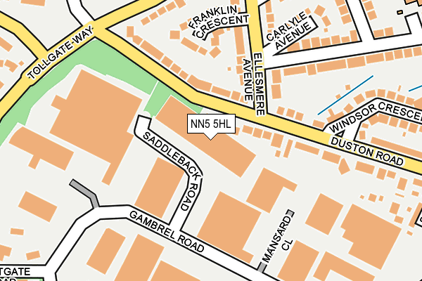
NN5 5HL is located in the Duston East electoral ward, within the unitary authority of West Northamptonshire and the English Parliamentary constituency of Northampton South. The Sub Integrated Care Board (ICB) Location is NHS Northamptonshire ICB - 78H and the police force is Northamptonshire. This postcode has been in use since January 1980.


GetTheData
Source: OS OpenMap – Local (Ordnance Survey)
Source: OS VectorMap District (Ordnance Survey)
Licence: Open Government Licence (requires attribution)
| Easting | 472935 |
| Northing | 260943 |
| Latitude | 52.241866 |
| Longitude | -0.933246 |
GetTheData
Source: Open Postcode Geo
Licence: Open Government Licence
| Country | England |
| Postcode District | NN5 |
| ➜ NN5 open data dashboard ➜ See where NN5 is on a map ➜ Where is Northampton? | |
GetTheData
Source: Land Registry Price Paid Data
Licence: Open Government Licence
Elevation or altitude of NN5 5HL as distance above sea level:
| Metres | Feet | |
|---|---|---|
| Elevation | 80m | 262ft |
Elevation is measured from the approximate centre of the postcode, to the nearest point on an OS contour line from OS Terrain 50, which has contour spacing of ten vertical metres.
➜ How high above sea level am I? Find the elevation of your current position using your device's GPS.
GetTheData
Source: Open Postcode Elevation
Licence: Open Government Licence
| Ward | Duston East |
| Constituency | Northampton South |
GetTheData
Source: ONS Postcode Database
Licence: Open Government Licence
| January 2024 | Anti-social behaviour | On or near Tollgate Way | 377m |
| December 2023 | Other theft | On or near Tollgate Way | 377m |
| November 2023 | Shoplifting | On or near Tollgate Way | 377m |
| ➜ Get more crime data in our Crime section | |||
GetTheData
Source: data.police.uk
Licence: Open Government Licence
| Ellesmere Avenue (Duston Road) | Duston | 72m |
| Ellesmere Avenue (Duston Road) | Duston | 153m |
| Duston Road (Bants Lane) | Duston | 215m |
| Duston Road (Bants Lane) | Duston | 217m |
| Lovat Drive (Ellesmere Avenue) | Duston | 229m |
| Northampton Station | 1.9km |
GetTheData
Source: NaPTAN
Licence: Open Government Licence
GetTheData
Source: ONS Postcode Database
Licence: Open Government Licence


➜ Get more ratings from the Food Standards Agency
GetTheData
Source: Food Standards Agency
Licence: FSA terms & conditions
| Last Collection | |||
|---|---|---|---|
| Location | Mon-Fri | Sat | Distance |
| Ellesmere Ave | 17:30 | 12:00 | 102m |
| Weedon Road | 18:30 | 12:15 | 432m |
| Weedon Road | 18:45 | 435m | |
GetTheData
Source: Dracos
Licence: Creative Commons Attribution-ShareAlike
| Facility | Distance |
|---|---|
| Bst Mma Gambrel Road, Westgate Industrial Estate, Northampton Health and Fitness Gym | 213m |
| The Gym Group (Northampton) Gambrel Road, Northampton Health and Fitness Gym | 299m |
| Nuffield Health (Northampton) Walter Tull Way, Sixfields, Northampton Swimming Pool, Health and Fitness Gym, Studio | 434m |
GetTheData
Source: Active Places
Licence: Open Government Licence
| School | Phase of Education | Distance |
|---|---|---|
| Lyncrest Primary School Lyncrest Avenue, Northampton, NN5 5PE | Primary | 355m |
| Millway Primary School Millway, Duston, Northampton, NN5 6ES | Primary | 504m |
| Chiltern Primary School Chiltern Way, Duston, Northampton, NN5 6BW | Primary | 675m |
GetTheData
Source: Edubase
Licence: Open Government Licence
The below table lists the International Territorial Level (ITL) codes (formerly Nomenclature of Territorial Units for Statistics (NUTS) codes) and Local Administrative Units (LAU) codes for NN5 5HL:
| ITL 1 Code | Name |
|---|---|
| TLF | East Midlands (England) |
| ITL 2 Code | Name |
| TLF2 | Leicestershire, Rutland and Northamptonshire |
| ITL 3 Code | Name |
| TLF24 | West Northamptonshire |
| LAU 1 Code | Name |
| E07000154 | Northampton |
GetTheData
Source: ONS Postcode Directory
Licence: Open Government Licence
The below table lists the Census Output Area (OA), Lower Layer Super Output Area (LSOA), and Middle Layer Super Output Area (MSOA) for NN5 5HL:
| Code | Name | |
|---|---|---|
| OA | E00169253 | |
| LSOA | E01027237 | Northampton 024C |
| MSOA | E02005673 | Northampton 024 |
GetTheData
Source: ONS Postcode Directory
Licence: Open Government Licence
| NN5 5AU | Duston Road | 84m |
| NN5 5NP | Ellesmere Avenue | 147m |
| NN5 5NS | Franklin Crescent | 158m |
| NN5 5NW | Ellesmere Avenue | 183m |
| NN5 6AL | Bants Lane | 195m |
| NN5 5AR | Duston Road | 196m |
| NN5 5NR | Carlyle Avenue | 227m |
| NN5 5AS | Duston Road | 267m |
| NN5 6AN | Westbury Close | 278m |
| NN5 5NT | Lovat Drive | 280m |
GetTheData
Source: Open Postcode Geo; Land Registry Price Paid Data
Licence: Open Government Licence