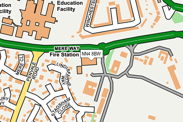
NN4 8BW is located in the East Hunsbury and Shelfleys electoral ward, within the unitary authority of West Northamptonshire and the English Parliamentary constituency of South Northamptonshire. The Sub Integrated Care Board (ICB) Location is NHS Northamptonshire ICB - 78H and the police force is Northamptonshire. This postcode has been in use since August 1993.


GetTheData
Source: OS OpenMap – Local (Ordnance Survey)
Source: OS VectorMap District (Ordnance Survey)
Licence: Open Government Licence (requires attribution)
| Easting | 475216 |
| Northing | 257882 |
| Latitude | 52.214030 |
| Longitude | -0.900540 |
GetTheData
Source: Open Postcode Geo
Licence: Open Government Licence
| Country | England |
| Postcode District | NN4 |
| ➜ NN4 open data dashboard ➜ See where NN4 is on a map ➜ Where is Northampton? | |
GetTheData
Source: Land Registry Price Paid Data
Licence: Open Government Licence
Elevation or altitude of NN4 8BW as distance above sea level:
| Metres | Feet | |
|---|---|---|
| Elevation | 100m | 328ft |
Elevation is measured from the approximate centre of the postcode, to the nearest point on an OS contour line from OS Terrain 50, which has contour spacing of ten vertical metres.
➜ How high above sea level am I? Find the elevation of your current position using your device's GPS.
GetTheData
Source: Open Postcode Elevation
Licence: Open Government Licence
| Ward | East Hunsbury And Shelfleys |
| Constituency | South Northamptonshire |
GetTheData
Source: ONS Postcode Database
Licence: Open Government Licence
| January 2024 | Anti-social behaviour | On or near Springbanks Way | 281m |
| January 2024 | Other theft | On or near Springbanks Way | 281m |
| December 2023 | Other theft | On or near Belton Close | 253m |
| ➜ Get more crime data in our Crime section | |||
GetTheData
Source: data.police.uk
Licence: Open Government Licence
| Fire Station (Mereway) | Delapre | 58m |
| London Road | Delapre | 306m |
| London Road | Delapre | 328m |
| Nene Valley Way Slip Road (London Road) | Hardingstone | 356m |
| Mereway Community College (Mereway) | Delapre | 359m |
| Northampton Station | 2.6km |
GetTheData
Source: NaPTAN
Licence: Open Government Licence
GetTheData
Source: ONS Postcode Database
Licence: Open Government Licence


➜ Get more ratings from the Food Standards Agency
GetTheData
Source: Food Standards Agency
Licence: FSA terms & conditions
| Last Collection | |||
|---|---|---|---|
| Location | Mon-Fri | Sat | Distance |
| Glastonbury Road | 17:30 | 12:00 | 296m |
| Clannel Road | 17:30 | 12:30 | 443m |
| Gloucester Avenue Tso | 17:30 | 12:00 | 594m |
GetTheData
Source: Dracos
Licence: Creative Commons Attribution-ShareAlike
| Facility | Distance |
|---|---|
| Wootton Park School Wootton Hall Park, Northampton Grass Pitches, Sports Hall | 196m |
| Wootton Hall (Closed) Mereway, Northampton Grass Pitches, Sports Hall | 266m |
| Abbeyfield School Mereway, Northampton Sports Hall, Health and Fitness Gym, Grass Pitches | 355m |
GetTheData
Source: Active Places
Licence: Open Government Licence
| School | Phase of Education | Distance |
|---|---|---|
| The Abbey Primary School Winchester Road, Delapre, Northampton, NN4 8AZ | Primary | 275m |
| Wootton Park School Wootton Hall Park, Northampton, NN4 0JA | All-through | 301m |
| Abbeyfield School Mereway, Northampton, NN4 8BU | Secondary | 355m |
GetTheData
Source: Edubase
Licence: Open Government Licence
The below table lists the International Territorial Level (ITL) codes (formerly Nomenclature of Territorial Units for Statistics (NUTS) codes) and Local Administrative Units (LAU) codes for NN4 8BW:
| ITL 1 Code | Name |
|---|---|
| TLF | East Midlands (England) |
| ITL 2 Code | Name |
| TLF2 | Leicestershire, Rutland and Northamptonshire |
| ITL 3 Code | Name |
| TLF24 | West Northamptonshire |
| LAU 1 Code | Name |
| E07000154 | Northampton |
GetTheData
Source: ONS Postcode Directory
Licence: Open Government Licence
The below table lists the Census Output Area (OA), Lower Layer Super Output Area (LSOA), and Middle Layer Super Output Area (MSOA) for NN4 8BW:
| Code | Name | |
|---|---|---|
| OA | E00138187 | |
| LSOA | E01027162 | Northampton 030A |
| MSOA | E02005679 | Northampton 030 |
GetTheData
Source: ONS Postcode Directory
Licence: Open Government Licence
| NN4 8AZ | Winchester Road | 111m |
| NN4 0WJ | Lindisfarne Way | 122m |
| NN4 0WH | Lindisfarne Way | 135m |
| NN4 8BA | Winchester Close | 169m |
| NN4 0WL | Lindisfarne Way | 171m |
| NN4 0WN | Lindisfarne Way | 174m |
| NN4 0WG | Lindisfarne Way | 184m |
| NN4 0WD | Scotney Close | 187m |
| NN4 0WE | Stagshaw Close | 191m |
| NN4 8AY | Winchester Road | 198m |
GetTheData
Source: Open Postcode Geo; Land Registry Price Paid Data
Licence: Open Government Licence