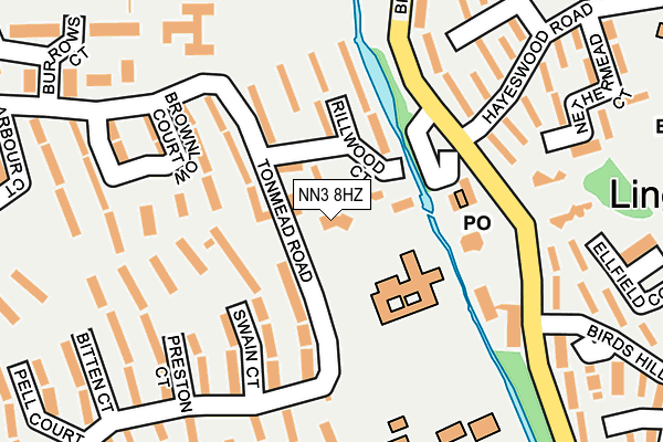
NN3 8HZ is located in the Talavera electoral ward, within the unitary authority of West Northamptonshire and the English Parliamentary constituency of Northampton North. The Sub Integrated Care Board (ICB) Location is NHS Northamptonshire ICB - 78H and the police force is Northamptonshire. This postcode has been in use since August 1993.


GetTheData
Source: OS OpenMap – Local (Ordnance Survey)
Source: OS VectorMap District (Ordnance Survey)
Licence: Open Government Licence (requires attribution)
| Easting | 479555 |
| Northing | 263429 |
| Latitude | 52.263295 |
| Longitude | -0.835728 |
GetTheData
Source: Open Postcode Geo
Licence: Open Government Licence
| Country | England |
| Postcode District | NN3 |
| ➜ NN3 open data dashboard ➜ See where NN3 is on a map ➜ Where is Northampton? | |
GetTheData
Source: Land Registry Price Paid Data
Licence: Open Government Licence
Elevation or altitude of NN3 8HZ as distance above sea level:
| Metres | Feet | |
|---|---|---|
| Elevation | 70m | 230ft |
Elevation is measured from the approximate centre of the postcode, to the nearest point on an OS contour line from OS Terrain 50, which has contour spacing of ten vertical metres.
➜ How high above sea level am I? Find the elevation of your current position using your device's GPS.
GetTheData
Source: Open Postcode Elevation
Licence: Open Government Licence
| Ward | Talavera |
| Constituency | Northampton North |
GetTheData
Source: ONS Postcode Database
Licence: Open Government Licence
| January 2024 | Criminal damage and arson | On or near Poppyfield Court | 371m |
| January 2024 | Violence and sexual offences | On or near Poppyfield Court | 371m |
| November 2023 | Anti-social behaviour | On or near Poppyfield Court | 371m |
| ➜ Get more crime data in our Crime section | |||
GetTheData
Source: data.police.uk
Licence: Open Government Licence
| Rillwood Medical Centre (Tonmead Road) | Lumbertubs | 116m |
| Brookside Community Centre (Billing Brook Road) | Lings | 118m |
| Brookside Community Centre (Billing Brook Road) | Lings | 127m |
| Rillwood Medical Centre (Tonmead Road) | Lumbertubs | 173m |
| Alexander Court (Penistone Road) | Lumbertubs | 249m |
| Northampton Station | 5.6km |
GetTheData
Source: NaPTAN
Licence: Open Government Licence
GetTheData
Source: ONS Postcode Database
Licence: Open Government Licence


➜ Get more ratings from the Food Standards Agency
GetTheData
Source: Food Standards Agency
Licence: FSA terms & conditions
| Last Collection | |||
|---|---|---|---|
| Location | Mon-Fri | Sat | Distance |
| Lumbertubs Tso | 17:30 | 11:30 | 98m |
| Penistone Road | 17:30 | 12:00 | 311m |
| Arbour Court | 17:30 | 12:00 | 356m |
GetTheData
Source: Dracos
Licence: Creative Commons Attribution-ShareAlike
| Facility | Distance |
|---|---|
| Lumbertubs Primary School Tonmead Road, Northampton Grass Pitches | 0m |
| Lings Primary School Hayeswood Road, Northampton Grass Pitches | 333m |
| Northampton Academy Wellingborough Road, Northampton Health and Fitness Gym, Sports Hall, Artificial Grass Pitch, Studio | 699m |
GetTheData
Source: Active Places
Licence: Open Government Licence
| School | Phase of Education | Distance |
|---|---|---|
| Lumbertubs Primary School Tonmead Road, Northampton, NN3 8HZ | Primary | 0m |
| Billing Brook Special School Penistone Road, Lumbertubs, Northampton, NN3 8EZ | Not applicable | 212m |
| Lings Primary School Hayeswood Road, Lings, Northampton, NN3 8NN | Primary | 333m |
GetTheData
Source: Edubase
Licence: Open Government Licence
The below table lists the International Territorial Level (ITL) codes (formerly Nomenclature of Territorial Units for Statistics (NUTS) codes) and Local Administrative Units (LAU) codes for NN3 8HZ:
| ITL 1 Code | Name |
|---|---|
| TLF | East Midlands (England) |
| ITL 2 Code | Name |
| TLF2 | Leicestershire, Rutland and Northamptonshire |
| ITL 3 Code | Name |
| TLF24 | West Northamptonshire |
| LAU 1 Code | Name |
| E07000154 | Northampton |
GetTheData
Source: ONS Postcode Directory
Licence: Open Government Licence
The below table lists the Census Output Area (OA), Lower Layer Super Output Area (LSOA), and Middle Layer Super Output Area (MSOA) for NN3 8HZ:
| Code | Name | |
|---|---|---|
| OA | E00138352 | |
| LSOA | E01027198 | Northampton 007C |
| MSOA | E02005656 | Northampton 007 |
GetTheData
Source: ONS Postcode Directory
Licence: Open Government Licence
| NN3 8JS | Rillwood Court | 87m |
| NN3 8HX | Tonmead Road | 98m |
| NN3 8JB | Rillwood Court | 128m |
| NN3 8NA | Springfield Court | 151m |
| NN3 8LS | Ellfield Court | 159m |
| NN3 8HT | Swain Court | 166m |
| NN3 8HP | Parva Court | 171m |
| NN3 8NE | Nethermead Court | 172m |
| NN3 8JA | Rillwood Court | 185m |
| NN3 8HU | Tonmead Road | 189m |
GetTheData
Source: Open Postcode Geo; Land Registry Price Paid Data
Licence: Open Government Licence