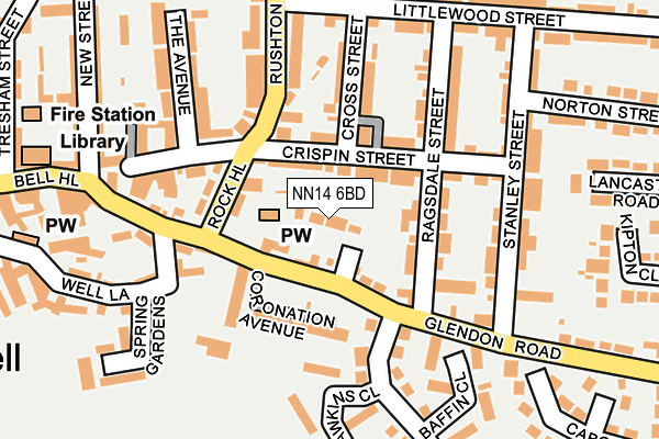
NN14 6BD is located in the Rothwell and Mawsley electoral ward, within the unitary authority of North Northamptonshire and the English Parliamentary constituency of Kettering. The Sub Integrated Care Board (ICB) Location is NHS Northamptonshire ICB - 78H and the police force is Northamptonshire. This postcode has been in use since August 1993.


GetTheData
Source: OS OpenMap – Local (Ordnance Survey)
Source: OS VectorMap District (Ordnance Survey)
Licence: Open Government Licence (requires attribution)
| Easting | 482018 |
| Northing | 281193 |
| Latitude | 52.422586 |
| Longitude | -0.795332 |
GetTheData
Source: Open Postcode Geo
Licence: Open Government Licence
| Country | England |
| Postcode District | NN14 |
| ➜ NN14 open data dashboard ➜ See where NN14 is on a map ➜ Where is Rothwell? | |
GetTheData
Source: Land Registry Price Paid Data
Licence: Open Government Licence
Elevation or altitude of NN14 6BD as distance above sea level:
| Metres | Feet | |
|---|---|---|
| Elevation | 120m | 394ft |
Elevation is measured from the approximate centre of the postcode, to the nearest point on an OS contour line from OS Terrain 50, which has contour spacing of ten vertical metres.
➜ How high above sea level am I? Find the elevation of your current position using your device's GPS.
GetTheData
Source: Open Postcode Elevation
Licence: Open Government Licence
| Ward | Rothwell And Mawsley |
| Constituency | Kettering |
GetTheData
Source: ONS Postcode Database
Licence: Open Government Licence
| January 2024 | Violence and sexual offences | On or near Spring Gardens | 203m |
| November 2023 | Violence and sexual offences | On or near Spring Gardens | 203m |
| November 2023 | Violence and sexual offences | On or near Spring Gardens | 203m |
| ➜ Get more crime data in our Crime section | |||
GetTheData
Source: data.police.uk
Licence: Open Government Licence
| Stanley Street (Glendon Road) | Rothwell | 209m |
| Stanley Street (Glendon Road) | Rothwell | 229m |
| Library (Bell Hill) | Rothwell | 280m |
| Market Hill (Bridge Street) | Rothwell | 336m |
| Market Hill (Bridge Street) | Rothwell | 346m |
| Kettering Station | 5.4km |
GetTheData
Source: NaPTAN
Licence: Open Government Licence
| Percentage of properties with Next Generation Access | 25.0% |
| Percentage of properties with Superfast Broadband | 25.0% |
| Percentage of properties with Ultrafast Broadband | 0.0% |
| Percentage of properties with Full Fibre Broadband | 0.0% |
Superfast Broadband is between 30Mbps and 300Mbps
Ultrafast Broadband is > 300Mbps
| Percentage of properties unable to receive 2Mbps | 0.0% |
| Percentage of properties unable to receive 5Mbps | 0.0% |
| Percentage of properties unable to receive 10Mbps | 0.0% |
| Percentage of properties unable to receive 30Mbps | 75.0% |
GetTheData
Source: Ofcom
Licence: Ofcom Terms of Use (requires attribution)
GetTheData
Source: ONS Postcode Database
Licence: Open Government Licence


➜ Get more ratings from the Food Standards Agency
GetTheData
Source: Food Standards Agency
Licence: FSA terms & conditions
| Last Collection | |||
|---|---|---|---|
| Location | Mon-Fri | Sat | Distance |
| Braybrooke Road | 16:00 | 08:30 | 2,980m |
| Harrington Road | 16:00 | 08:45 | 3,086m |
| Dunkirk Avenue | 16:00 | 08:30 | 3,535m |
GetTheData
Source: Dracos
Licence: Creative Commons Attribution-ShareAlike
| Facility | Distance |
|---|---|
| Rothwell Recreation Ground Well Lane, Rothwell Grass Pitches | 171m |
| Cecil Street Playing Field (Closed) Cecil Street, Rothwell, Kettering Grass Pitches | 456m |
| Steps Fitness Club (Closed) Bridge Street, Rothwell, Kettering Health and Fitness Gym | 487m |
GetTheData
Source: Active Places
Licence: Open Government Licence
| School | Phase of Education | Distance |
|---|---|---|
| Rothwell Junior School Gladstone Street, Rothwell, Kettering, NN14 6ER | Primary | 444m |
| Rothwell Victoria Infant School School Lane, Rothwell, Kettering, NN14 6HZ | Primary | 481m |
| Montsaye Academy Greening Road, Rothwell, Kettering, NN14 6BB | Secondary | 1km |
GetTheData
Source: Edubase
Licence: Open Government Licence
The below table lists the International Territorial Level (ITL) codes (formerly Nomenclature of Territorial Units for Statistics (NUTS) codes) and Local Administrative Units (LAU) codes for NN14 6BD:
| ITL 1 Code | Name |
|---|---|
| TLF | East Midlands (England) |
| ITL 2 Code | Name |
| TLF2 | Leicestershire, Rutland and Northamptonshire |
| ITL 3 Code | Name |
| TLF25 | North Northamptonshire |
| LAU 1 Code | Name |
| E07000153 | Kettering |
GetTheData
Source: ONS Postcode Directory
Licence: Open Government Licence
The below table lists the Census Output Area (OA), Lower Layer Super Output Area (LSOA), and Middle Layer Super Output Area (MSOA) for NN14 6BD:
| Code | Name | |
|---|---|---|
| OA | E00137988 | |
| LSOA | E01027126 | Kettering 003D |
| MSOA | E02005641 | Kettering 003 |
GetTheData
Source: ONS Postcode Directory
Licence: Open Government Licence
| NN14 6BZ | Crispin Street | 66m |
| NN14 6DA | Crispin Street | 77m |
| NN14 6BS | Glendon Road | 78m |
| NN14 6DE | Ragsdale Street | 103m |
| NN14 6DG | Coronation Avenue | 108m |
| NN14 6DD | Cross Street | 110m |
| NN14 6BY | Rock Hill | 117m |
| NN14 6EA | Stanley Street | 150m |
| NN14 6DF | Ragsdale Street | 153m |
| NN14 6DB | Crispin Street | 153m |
GetTheData
Source: Open Postcode Geo; Land Registry Price Paid Data
Licence: Open Government Licence