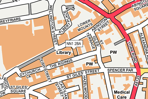
NN1 2BA is located in the Castle electoral ward, within the unitary authority of West Northamptonshire and the English Parliamentary constituency of Northampton South. The Sub Integrated Care Board (ICB) Location is NHS Northamptonshire ICB - 78H and the police force is Northamptonshire. This postcode has been in use since January 1980.


GetTheData
Source: OS OpenMap – Local (Ordnance Survey)
Source: OS VectorMap District (Ordnance Survey)
Licence: Open Government Licence (requires attribution)
| Easting | 475785 |
| Northing | 260616 |
| Latitude | 52.238527 |
| Longitude | -0.891602 |
GetTheData
Source: Open Postcode Geo
Licence: Open Government Licence
| Country | England |
| Postcode District | NN1 |
| ➜ NN1 open data dashboard ➜ See where NN1 is on a map ➜ Where is Northampton? | |
GetTheData
Source: Land Registry Price Paid Data
Licence: Open Government Licence
Elevation or altitude of NN1 2BA as distance above sea level:
| Metres | Feet | |
|---|---|---|
| Elevation | 80m | 262ft |
Elevation is measured from the approximate centre of the postcode, to the nearest point on an OS contour line from OS Terrain 50, which has contour spacing of ten vertical metres.
➜ How high above sea level am I? Find the elevation of your current position using your device's GPS.
GetTheData
Source: Open Postcode Elevation
Licence: Open Government Licence
| Ward | Castle |
| Constituency | Northampton South |
GetTheData
Source: ONS Postcode Database
Licence: Open Government Licence
| January 2024 | Public order | On or near Parking Area | 258m |
| January 2024 | Anti-social behaviour | On or near Parking Area | 385m |
| January 2024 | Anti-social behaviour | On or near Swan Street | 404m |
| ➜ Get more crime data in our Crime section | |||
GetTheData
Source: data.police.uk
Licence: Open Government Licence
| Lower Mounts | Northampton | 183m |
| Post Office (St Giles Street) | Northampton | 186m |
| Abington Square (York Road) | Northampton | 211m |
| Derngate Centre (Derngate) | Northampton | 225m |
| Derngate Centre (Derngate) | Northampton | 241m |
| Northampton Station | 1km |
GetTheData
Source: NaPTAN
Licence: Open Government Licence
GetTheData
Source: ONS Postcode Database
Licence: Open Government Licence


➜ Get more ratings from the Food Standards Agency
GetTheData
Source: Food Standards Agency
Licence: FSA terms & conditions
| Last Collection | |||
|---|---|---|---|
| Location | Mon-Fri | Sat | Distance |
| Abington Street | 18:30 | 11:30 | 75m |
| Abington St | 18:30 | 92m | |
| St Giles Street | 19:15 | 212m | |
GetTheData
Source: Dracos
Licence: Creative Commons Attribution-ShareAlike
| Facility | Distance |
|---|---|
| Energie Fitness (Northampton) (Closed) Abington Street, Northampton Health and Fitness Gym, Studio | 72m |
| Derngate Gym (Closed) Derngate, Northampton Health and Fitness Gym, Studio | 221m |
| Mounts Baths Leisure Centre Upper Mounts, Northampton Swimming Pool, Health and Fitness Gym, Studio | 338m |
GetTheData
Source: Active Places
Licence: Open Government Licence
| School | Phase of Education | Distance |
|---|---|---|
| Progress Schools - Northamptonshire 8 Notre Dame Mew, Northampton, NN1 2BG | Not applicable | 129m |
| New Horizons School 59-77 Sheep Street, Northampton, NN1 2NE | Not applicable | 580m |
| Castle Academy St George's Street, Northampton, NN1 2TR | Primary | 739m |
GetTheData
Source: Edubase
Licence: Open Government Licence
The below table lists the International Territorial Level (ITL) codes (formerly Nomenclature of Territorial Units for Statistics (NUTS) codes) and Local Administrative Units (LAU) codes for NN1 2BA:
| ITL 1 Code | Name |
|---|---|
| TLF | East Midlands (England) |
| ITL 2 Code | Name |
| TLF2 | Leicestershire, Rutland and Northamptonshire |
| ITL 3 Code | Name |
| TLF24 | West Northamptonshire |
| LAU 1 Code | Name |
| E07000154 | Northampton |
GetTheData
Source: ONS Postcode Directory
Licence: Open Government Licence
The below table lists the Census Output Area (OA), Lower Layer Super Output Area (LSOA), and Middle Layer Super Output Area (MSOA) for NN1 2BA:
| Code | Name | |
|---|---|---|
| OA | E00138514 | |
| LSOA | E01027223 | Northampton 025A |
| MSOA | E02005674 | Northampton 025 |
GetTheData
Source: ONS Postcode Directory
Licence: Open Government Licence
| NN1 2AP | Abington Street | 22m |
| NN1 2AW | Abington Street | 69m |
| NN1 2AQ | The Ridings | 84m |
| NN1 3AS | Wellington Street | 92m |
| NN1 1JF | St Giles Street | 97m |
| NN1 2BH | Abington Street | 102m |
| NN1 2BN | St Giles Terrace | 113m |
| NN1 1JW | St Giles Street | 124m |
| NN1 1LD | Castilian Terrace | 145m |
| NN1 2BP | Abington Street | 166m |
GetTheData
Source: Open Postcode Geo; Land Registry Price Paid Data
Licence: Open Government Licence