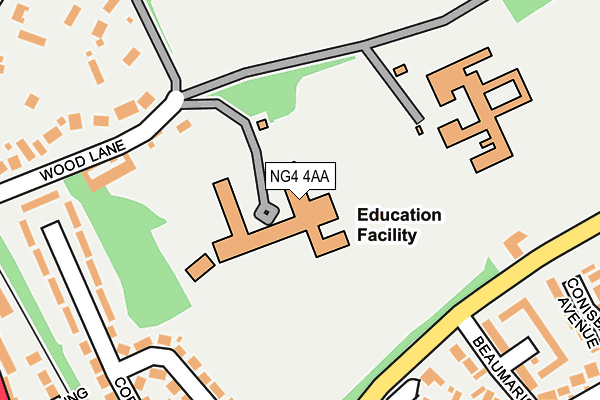
NG4 4AA is located in the Trent Valley electoral ward, within the local authority district of Gedling and the English Parliamentary constituency of Gedling. The Sub Integrated Care Board (ICB) Location is NHS Nottingham and Nottinghamshire ICB - 52R and the police force is Nottinghamshire. This postcode has been in use since January 1980.


GetTheData
Source: OS OpenMap – Local (Ordnance Survey)
Source: OS VectorMap District (Ordnance Survey)
Licence: Open Government Licence (requires attribution)
| Easting | 462556 |
| Northing | 342431 |
| Latitude | 52.975589 |
| Longitude | -1.069853 |
GetTheData
Source: Open Postcode Geo
Licence: Open Government Licence
| Country | England |
| Postcode District | NG4 |
| ➜ NG4 open data dashboard ➜ See where NG4 is on a map ➜ Where is Carlton? | |
GetTheData
Source: Land Registry Price Paid Data
Licence: Open Government Licence
Elevation or altitude of NG4 4AA as distance above sea level:
| Metres | Feet | |
|---|---|---|
| Elevation | 30m | 98ft |
Elevation is measured from the approximate centre of the postcode, to the nearest point on an OS contour line from OS Terrain 50, which has contour spacing of ten vertical metres.
➜ How high above sea level am I? Find the elevation of your current position using your device's GPS.
GetTheData
Source: Open Postcode Elevation
Licence: Open Government Licence
| Ward | Trent Valley |
| Constituency | Gedling |
GetTheData
Source: ONS Postcode Database
Licence: Open Government Licence
| January 2024 | Violence and sexual offences | On or near Beaumaris Drive | 361m |
| January 2024 | Other crime | On or near Beaumaris Drive | 361m |
| May 2023 | Violence and sexual offences | On or near Beaumaris Drive | 361m |
| ➜ Get more crime data in our Crime section | |||
GetTheData
Source: data.police.uk
Licence: Open Government Licence
| Beaumaris Drive (Burton Road) | Gedling | 183m |
| Linden Grove (Burton Road) | Gedling | 278m |
| Linden Grove (Burton Road) | Gedling | 332m |
| Station Avenue (Shearing Hill) | Gedling | 346m |
| Florence Road (Burton Road) | Gedling | 353m |
| Carlton Station | 1.3km |
| Netherfield Station | 1.7km |
| Burton Joyce Station | 2.1km |
GetTheData
Source: NaPTAN
Licence: Open Government Licence
GetTheData
Source: ONS Postcode Database
Licence: Open Government Licence

➜ Get more ratings from the Food Standards Agency
GetTheData
Source: Food Standards Agency
Licence: FSA terms & conditions
| Last Collection | |||
|---|---|---|---|
| Location | Mon-Fri | Sat | Distance |
| Beaumaris Drive | 17:00 | 11:00 | 211m |
| Coronation Walk | 17:00 | 11:00 | 230m |
| Stoke Lane | 17:00 | 12:00 | 322m |
GetTheData
Source: Dracos
Licence: Creative Commons Attribution-ShareAlike
| Facility | Distance |
|---|---|
| Carlton-le-willows Academy Wood Lane, Gedling, Nottingham Athletics, Sports Hall, Grass Pitches, Health and Fitness Gym, Artificial Grass Pitch | 0m |
| Burton Road Jubilee Park Burton Road, Gedling, Nottingham Grass Pitches | 509m |
| Bill Stokeld Stadium Stoke Lane, Gedling Grass Pitches, Artificial Grass Pitch | 677m |
GetTheData
Source: Active Places
Licence: Open Government Licence
| School | Phase of Education | Distance |
|---|---|---|
| Carlton le Willows Academy Wood Lane, Nottingham, Gedling, NG4 4AA | Secondary | 136m |
| Willow Farm Primary School Willow Lane, Gedling, Nottingham, NG4 4BN | Primary | 516m |
| All Hallows CofE Primary School Priory Road, Gedling, Nottingham, NG4 3JZ | Primary | 821m |
GetTheData
Source: Edubase
Licence: Open Government Licence
The below table lists the International Territorial Level (ITL) codes (formerly Nomenclature of Territorial Units for Statistics (NUTS) codes) and Local Administrative Units (LAU) codes for NG4 4AA:
| ITL 1 Code | Name |
|---|---|
| TLF | East Midlands (England) |
| ITL 2 Code | Name |
| TLF1 | Derbyshire and Nottinghamshire |
| ITL 3 Code | Name |
| TLF16 | South Nottinghamshire |
| LAU 1 Code | Name |
| E07000173 | Gedling |
GetTheData
Source: ONS Postcode Directory
Licence: Open Government Licence
The below table lists the Census Output Area (OA), Lower Layer Super Output Area (LSOA), and Middle Layer Super Output Area (MSOA) for NG4 4AA:
| Code | Name | |
|---|---|---|
| OA | E00143532 | |
| LSOA | E01028170 | Gedling 012C |
| MSOA | E02005876 | Gedling 012 |
GetTheData
Source: ONS Postcode Directory
Licence: Open Government Licence
| NG4 4AR | Coronation Walk | 197m |
| NG4 4AT | Burton Road | 215m |
| NG4 4AS | Coronation Walk | 267m |
| NG4 2RG | Pendennis Close | 269m |
| NG4 2RB | Braemar Drive | 274m |
| NG4 4AQ | Coronation Walk | 278m |
| NG4 2AX | Senso Court | 281m |
| NG4 4AD | Wood Lane | 309m |
| NG4 3GJ | Shearing Close | 323m |
| NG4 2RE | Conisbrough Avenue | 324m |
GetTheData
Source: Open Postcode Geo; Land Registry Price Paid Data
Licence: Open Government Licence