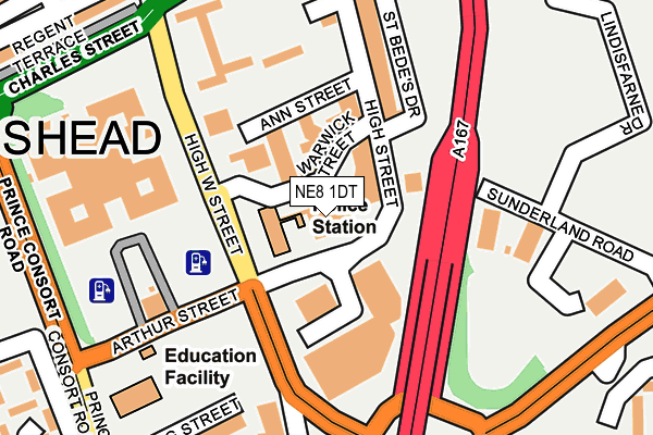
NE8 1DT is located in the Bridges electoral ward, within the metropolitan district of Gateshead and the English Parliamentary constituency of Gateshead. The Sub Integrated Care Board (ICB) Location is NHS North East and North Cumbria ICB - 13T and the police force is Northumbria. This postcode has been in use since August 1992.


GetTheData
Source: OS OpenMap – Local (Ordnance Survey)
Source: OS VectorMap District (Ordnance Survey)
Licence: Open Government Licence (requires attribution)
| Easting | 425693 |
| Northing | 562778 |
| Latitude | 54.958982 |
| Longitude | -1.600300 |
GetTheData
Source: Open Postcode Geo
Licence: Open Government Licence
| Country | England |
| Postcode District | NE8 |
| ➜ NE8 open data dashboard ➜ See where NE8 is on a map ➜ Where is Gateshead? | |
GetTheData
Source: Land Registry Price Paid Data
Licence: Open Government Licence
Elevation or altitude of NE8 1DT as distance above sea level:
| Metres | Feet | |
|---|---|---|
| Elevation | 60m | 197ft |
Elevation is measured from the approximate centre of the postcode, to the nearest point on an OS contour line from OS Terrain 50, which has contour spacing of ten vertical metres.
➜ How high above sea level am I? Find the elevation of your current position using your device's GPS.
GetTheData
Source: Open Postcode Elevation
Licence: Open Government Licence
| Ward | Bridges |
| Constituency | Gateshead |
GetTheData
Source: ONS Postcode Database
Licence: Open Government Licence
| June 2022 | Anti-social behaviour | On or near High West Street | 89m |
| June 2022 | Public order | On or near High West Street | 89m |
| June 2022 | Violence and sexual offences | On or near High West Street | 89m |
| ➜ Get more crime data in our Crime section | |||
GetTheData
Source: data.police.uk
Licence: Open Government Licence
| High Street | Gateshead | 64m |
| High Street | Gateshead | 101m |
| High Street | Gateshead | 113m |
| High Street | Gateshead | 134m |
| High West Street-civic Centre (High West Street) | Gateshead | 152m |
| Gateshead (Tyne And Wear Metro Station) (Bensham Road) | Gateshead | 351m |
| Gateshead Stadium (Tyne And Wear Metro Station) (St James Road) | Gateshead Stadium | 794m |
| Central Station (Tyne And Wear Metro Station) (Neville Street) | Newcastle Upon Tyne | 1,516m |
| Newcastle Station | 1.5km |
| Manors Station | 1.6km |
| Dunston Station | 2.9km |
GetTheData
Source: NaPTAN
Licence: Open Government Licence
GetTheData
Source: ONS Postcode Database
Licence: Open Government Licence

➜ Get more ratings from the Food Standards Agency
GetTheData
Source: Food Standards Agency
Licence: FSA terms & conditions
| Last Collection | |||
|---|---|---|---|
| Location | Mon-Fri | Sat | Distance |
| Gateshead Delivery Office | 18:30 | 12:15 | 113m |
| High Street Post Office | 18:30 | 12:15 | 203m |
| Jackson Street | 18:30 | 12:00 | 321m |
GetTheData
Source: Dracos
Licence: Creative Commons Attribution-ShareAlike
| Facility | Distance |
|---|---|
| Ladies Fitness Studio High Street, Gateshead Health and Fitness Gym, Studio | 336m |
| Swallow Leisure (Gateshead) (Closed) High West Street, Gateshead Health and Fitness Gym, Swimming Pool | 336m |
| Puregym (Gateshead) Jackson Street, Gateshead Health and Fitness Gym, Studio | 341m |
GetTheData
Source: Active Places
Licence: Open Government Licence
| School | Phase of Education | Distance |
|---|---|---|
| The Gateshead Cheder Primary School Bede House, Sunderland Road, Gateshead, NE8 3HY | Not applicable | 188m |
| St Joseph's Catholic Primary School, Gateshead Prince Consort Road, Gateshead, NE8 1LR | Primary | 243m |
| Keser Girls School Ely Street, NE8 1NR | Not applicable | 384m |
GetTheData
Source: Edubase
Licence: Open Government Licence
The below table lists the International Territorial Level (ITL) codes (formerly Nomenclature of Territorial Units for Statistics (NUTS) codes) and Local Administrative Units (LAU) codes for NE8 1DT:
| ITL 1 Code | Name |
|---|---|
| TLC | North East (England) |
| ITL 2 Code | Name |
| TLC2 | Northumberland, and Tyne and Wear |
| ITL 3 Code | Name |
| TLC22 | Tyneside |
| LAU 1 Code | Name |
| E08000037 | Gateshead |
GetTheData
Source: ONS Postcode Directory
Licence: Open Government Licence
The below table lists the Census Output Area (OA), Lower Layer Super Output Area (LSOA), and Middle Layer Super Output Area (MSOA) for NE8 1DT:
| Code | Name | |
|---|---|---|
| OA | E00041380 | |
| LSOA | E01008166 | Gateshead 027C |
| MSOA | E02006841 | Gateshead 027 |
GetTheData
Source: ONS Postcode Directory
Licence: Open Government Licence
| NE8 1EN | High Street | 73m |
| NE8 1EQ | High Street | 168m |
| NE8 1HA | Regent Court | 192m |
| NE8 1EL | High Street | 212m |
| NE8 1NP | Coburg Street | 240m |
| NE8 1EP | High Street | 273m |
| NE8 1NQ | Denmark Street | 281m |
| NE8 4DP | Bewick Road | 300m |
| NE8 1LU | Regent Terrace | 304m |
| NE8 1EE | Jackson Street | 304m |
GetTheData
Source: Open Postcode Geo; Land Registry Price Paid Data
Licence: Open Government Licence