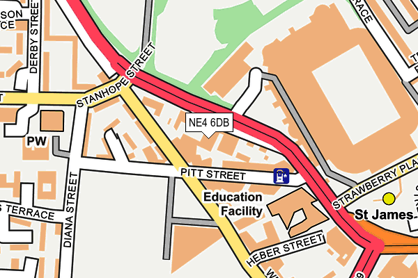
NE4 6DB is located in the Arthur's Hill electoral ward, within the metropolitan district of Newcastle upon Tyne and the English Parliamentary constituency of Newcastle upon Tyne Central. The Sub Integrated Care Board (ICB) Location is NHS North East and North Cumbria ICB - 13T and the police force is Northumbria. This postcode has been in use since January 1991.


GetTheData
Source: OS OpenMap – Local (Ordnance Survey)
Source: OS VectorMap District (Ordnance Survey)
Licence: Open Government Licence (requires attribution)
| Easting | 424107 |
| Northing | 564549 |
| Latitude | 54.974982 |
| Longitude | -1.624932 |
GetTheData
Source: Open Postcode Geo
Licence: Open Government Licence
| Country | England |
| Postcode District | NE4 |
| ➜ NE4 open data dashboard ➜ See where NE4 is on a map ➜ Where is Newcastle upon Tyne? | |
GetTheData
Source: Land Registry Price Paid Data
Licence: Open Government Licence
Elevation or altitude of NE4 6DB as distance above sea level:
| Metres | Feet | |
|---|---|---|
| Elevation | 60m | 197ft |
Elevation is measured from the approximate centre of the postcode, to the nearest point on an OS contour line from OS Terrain 50, which has contour spacing of ten vertical metres.
➜ How high above sea level am I? Find the elevation of your current position using your device's GPS.
GetTheData
Source: Open Postcode Elevation
Licence: Open Government Licence
| Ward | Arthur's Hill |
| Constituency | Newcastle Upon Tyne Central |
GetTheData
Source: ONS Postcode Database
Licence: Open Government Licence
| January 2024 | Anti-social behaviour | On or near Parking Area | 274m |
| January 2024 | Anti-social behaviour | On or near Parking Area | 274m |
| January 2024 | Drugs | On or near Parking Area | 274m |
| ➜ Get more crime data in our Crime section | |||
GetTheData
Source: data.police.uk
Licence: Open Government Licence
| Barrack Road-leazes Park (Barrack Road) | Newcastle Upon Tyne | 100m |
| Barrack Road-st James Park (Barrack Road) | Newcastle Upon Tyne | 118m |
| Barrack Road-st James Park (Barrack Road) | Newcastle Upon Tyne | 136m |
| Barrack Road-leazes Park (A189) | Newcastle Upon Tyne | 181m |
| Strawberry Place | Newcastle Upon Tyne | 287m |
| St James (Tyne And Wear Metro Station) (Strawberry Place) | Newcastle Upon Tyne | 272m |
| Monument (Tyne And Wear Metro Station) (Blackett Street) | Newcastle Upon Tyne | 743m |
| Haymarket (Tyne And Wear Metro Station) (Percy Street) | Newcastle Upon Tyne | 761m |
| Central Station (Tyne And Wear Metro Station) (Neville Street) | Newcastle Upon Tyne | 861m |
| Manors (Tyne And Wear Metro Station) (Argyll Street) | Manors | 1,291m |
| Newcastle Station | 0.9km |
| Manors Station | 1.3km |
| Dunston Station | 3km |
GetTheData
Source: NaPTAN
Licence: Open Government Licence
GetTheData
Source: ONS Postcode Database
Licence: Open Government Licence


➜ Get more ratings from the Food Standards Agency
GetTheData
Source: Food Standards Agency
Licence: FSA terms & conditions
| Last Collection | |||
|---|---|---|---|
| Location | Mon-Fri | Sat | Distance |
| Hollywell Close | 17:45 | 12:00 | 282m |
| Bath Lane | 17:30 | 12:00 | 286m |
| St James Street | 18:30 | 12:15 | 321m |
GetTheData
Source: Dracos
Licence: Creative Commons Attribution-ShareAlike
| Facility | Distance |
|---|---|
| Newcastle United (St James Park) Strawberry Place, Newcastle Upon Tyne Grass Pitches | 168m |
| Nucastle Diana Street, Newcastle Upon Tyne Sports Hall, Artificial Grass Pitch | 241m |
| Murray House Community Centre (Closed) Diana Street, Newcastle Upon Tyne Sports Hall | 254m |
GetTheData
Source: Active Places
Licence: Open Government Licence
| School | Phase of Education | Distance |
|---|---|---|
| Our Lady and St Anne's Catholic Primary School Summerhill Terrace, Newcastle-upon-Tyne, NE4 6EB | Primary | 653m |
| St Paul's CofE Primary School Victoria Street, Newcastle-upon-Tyne, NE4 7JU | Primary | 672m |
| Moorside Primary School Beaconsfield Street, Newcastle-upon-Tyne, NE4 5AW | Primary | 718m |
GetTheData
Source: Edubase
Licence: Open Government Licence
The below table lists the International Territorial Level (ITL) codes (formerly Nomenclature of Territorial Units for Statistics (NUTS) codes) and Local Administrative Units (LAU) codes for NE4 6DB:
| ITL 1 Code | Name |
|---|---|
| TLC | North East (England) |
| ITL 2 Code | Name |
| TLC2 | Northumberland, and Tyne and Wear |
| ITL 3 Code | Name |
| TLC22 | Tyneside |
| LAU 1 Code | Name |
| E08000021 | Newcastle upon Tyne |
GetTheData
Source: ONS Postcode Directory
Licence: Open Government Licence
The below table lists the Census Output Area (OA), Lower Layer Super Output Area (LSOA), and Middle Layer Super Output Area (MSOA) for NE4 6DB:
| Code | Name | |
|---|---|---|
| OA | E00042820 | |
| LSOA | E01033554 | Newcastle upon Tyne 024I |
| MSOA | E02001731 | Newcastle upon Tyne 024 |
GetTheData
Source: ONS Postcode Directory
Licence: Open Government Licence
| NE4 6BA | Barrack Road | 52m |
| NE4 5TA | Wellington Street | 101m |
| NE4 5TD | Spring Garden Lane | 120m |
| NE4 5ST | Pitt Street | 138m |
| NE4 6BH | Stanhope Street | 168m |
| NE4 6BP | Diana Street | 176m |
| NE4 6BN | Barrack Road | 224m |
| NE4 6BT | Douglas Terrace | 254m |
| NE4 6BJ | Barrack Road | 256m |
| NE4 6BQ | Diana Street | 282m |
GetTheData
Source: Open Postcode Geo; Land Registry Price Paid Data
Licence: Open Government Licence