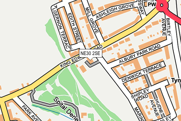
NE30 2SE lies on Mariners Lane in North Shields. NE30 2SE is located in the Tynemouth electoral ward, within the metropolitan district of North Tyneside and the English Parliamentary constituency of Tynemouth. The Sub Integrated Care Board (ICB) Location is NHS North East and North Cumbria ICB - 99C and the police force is Northumbria. This postcode has been in use since January 1993.


GetTheData
Source: OS OpenMap – Local (Ordnance Survey)
Source: OS VectorMap District (Ordnance Survey)
Licence: Open Government Licence (requires attribution)
| Easting | 436250 |
| Northing | 569393 |
| Latitude | 55.017777 |
| Longitude | -1.434625 |
GetTheData
Source: Open Postcode Geo
Licence: Open Government Licence
| Street | Mariners Lane |
| Town/City | North Shields |
| Country | England |
| Postcode District | NE30 |
➜ See where NE30 is on a map ➜ Where is Tynemouth? | |
GetTheData
Source: Land Registry Price Paid Data
Licence: Open Government Licence
Elevation or altitude of NE30 2SE as distance above sea level:
| Metres | Feet | |
|---|---|---|
| Elevation | 30m | 98ft |
Elevation is measured from the approximate centre of the postcode, to the nearest point on an OS contour line from OS Terrain 50, which has contour spacing of ten vertical metres.
➜ How high above sea level am I? Find the elevation of your current position using your device's GPS.
GetTheData
Source: Open Postcode Elevation
Licence: Open Government Licence
| Ward | Tynemouth |
| Constituency | Tynemouth |
GetTheData
Source: ONS Postcode Database
Licence: Open Government Licence
28, ST. AIDANS COURT, MARINERS LANE, NORTH SHIELDS, NE30 2SE 2000 5 OCT £105,000 |
GetTheData
Source: HM Land Registry Price Paid Data
Licence: Contains HM Land Registry data © Crown copyright and database right 2025. This data is licensed under the Open Government Licence v3.0.
| King Edward Road-mariners Lane (King Edward Road) | Tynemouth | 55m |
| King Edward Road-mill Grove (King Edward Road) | Tynemouth | 134m |
| Linskill Terrace-washington Tce (Linskill Terrace) | North Shields | 323m |
| Manor Road-king Edward Road (Manor Road) | Tynemouth | 326m |
| The Broadway-crossway (The Broadway) | Tynemouth | 337m |
| Tynemouth (Tyne And Wear Metro Station) (Station Terrace) | Tynemouth | 391m |
| North Shields (Tyne And Wear Metro Station) (Railway Terrace) | North Shields | 1,385m |
GetTheData
Source: NaPTAN
Licence: Open Government Licence
| Percentage of properties with Next Generation Access | 100.0% |
| Percentage of properties with Superfast Broadband | 100.0% |
| Percentage of properties with Ultrafast Broadband | 0.0% |
| Percentage of properties with Full Fibre Broadband | 0.0% |
Superfast Broadband is between 30Mbps and 300Mbps
Ultrafast Broadband is > 300Mbps
| Median download speed | 55.0Mbps |
| Average download speed | 48.0Mbps |
| Maximum download speed | 76.57Mbps |
| Median upload speed | 10.0Mbps |
| Average upload speed | 11.0Mbps |
| Maximum upload speed | 20.00Mbps |
| Percentage of properties unable to receive 2Mbps | 0.0% |
| Percentage of properties unable to receive 5Mbps | 0.0% |
| Percentage of properties unable to receive 10Mbps | 0.0% |
| Percentage of properties unable to receive 30Mbps | 0.0% |
GetTheData
Source: Ofcom
Licence: Ofcom Terms of Use (requires attribution)
Estimated total energy consumption in NE30 2SE by fuel type, 2015.
| Consumption (kWh) | 162,378 |
|---|---|
| Meter count | 28 |
| Mean (kWh/meter) | 5,799 |
| Median (kWh/meter) | 5,251 |
| Consumption (kWh) | 43,999 |
|---|---|
| Meter count | 28 |
| Mean (kWh/meter) | 1,571 |
| Median (kWh/meter) | 1,674 |
GetTheData
Source: Postcode level gas estimates: 2015 (experimental)
Source: Postcode level electricity estimates: 2015 (experimental)
Licence: Open Government Licence
GetTheData
Source: ONS Postcode Database
Licence: Open Government Licence


➜ Get more ratings from the Food Standards Agency
GetTheData
Source: Food Standards Agency
Licence: FSA terms & conditions
| Last Collection | |||
|---|---|---|---|
| Location | Mon-Fri | Sat | Distance |
| Edith Street | 16:15 | 11:45 | 99m |
| Broadway | 16:15 | 11:45 | 347m |
| Mariners Lane | 16:15 | 11:45 | 366m |
GetTheData
Source: Dracos
Licence: Creative Commons Attribution-ShareAlike
The below table lists the International Territorial Level (ITL) codes (formerly Nomenclature of Territorial Units for Statistics (NUTS) codes) and Local Administrative Units (LAU) codes for NE30 2SE:
| ITL 1 Code | Name |
|---|---|
| TLC | North East (England) |
| ITL 2 Code | Name |
| TLC2 | Northumberland, and Tyne and Wear |
| ITL 3 Code | Name |
| TLC22 | Tyneside |
| LAU 1 Code | Name |
| E08000022 | North Tyneside |
GetTheData
Source: ONS Postcode Directory
Licence: Open Government Licence
The below table lists the Census Output Area (OA), Lower Layer Super Output Area (LSOA), and Middle Layer Super Output Area (MSOA) for NE30 2SE:
| Code | Name | |
|---|---|---|
| OA | E00043452 | |
| LSOA | E01008558 | North Tyneside 016A |
| MSOA | E02001753 | North Tyneside 016 |
GetTheData
Source: ONS Postcode Directory
Licence: Open Government Licence
| NE30 2PL | Livingstone View | 60m |
| NE30 2SJ | Mariners Lane | 90m |
| NE30 2SN | King Edward Road | 98m |
| NE30 2JR | Mill Grove | 131m |
| NE30 2SD | Mariners Lane | 151m |
| NE30 2PN | Edith Street | 153m |
| NE30 2PW | Algernon Terrace | 159m |
| NE30 2RP | King Edward Road | 184m |
| NE30 2JP | Mill Grove | 191m |
| NE30 2SQ | Brislee Avenue | 192m |
GetTheData
Source: Open Postcode Geo; Land Registry Price Paid Data
Licence: Open Government Licence