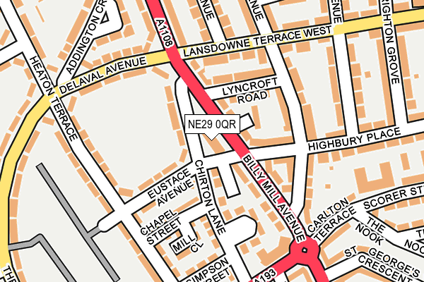
NE29 0QR is located in the Chirton electoral ward, within the metropolitan district of North Tyneside and the English Parliamentary constituency of Tynemouth. The Sub Integrated Care Board (ICB) Location is NHS North East and North Cumbria ICB - 99C and the police force is Northumbria. This postcode has been in use since January 1980.


GetTheData
Source: OS OpenMap – Local (Ordnance Survey)
Source: OS VectorMap District (Ordnance Survey)
Licence: Open Government Licence (requires attribution)
| Easting | 434451 |
| Northing | 568510 |
| Latitude | 55.009970 |
| Longitude | -1.462865 |
GetTheData
Source: Open Postcode Geo
Licence: Open Government Licence
| Country | England |
| Postcode District | NE29 |
| ➜ NE29 open data dashboard ➜ See where NE29 is on a map ➜ Where is Tynemouth? | |
GetTheData
Source: Land Registry Price Paid Data
Licence: Open Government Licence
Elevation or altitude of NE29 0QR as distance above sea level:
| Metres | Feet | |
|---|---|---|
| Elevation | 50m | 164ft |
Elevation is measured from the approximate centre of the postcode, to the nearest point on an OS contour line from OS Terrain 50, which has contour spacing of ten vertical metres.
➜ How high above sea level am I? Find the elevation of your current position using your device's GPS.
GetTheData
Source: Open Postcode Elevation
Licence: Open Government Licence
| Ward | Chirton |
| Constituency | Tynemouth |
GetTheData
Source: ONS Postcode Database
Licence: Open Government Licence
| January 2024 | Other theft | On or near Delaval Avenue | 179m |
| January 2024 | Public order | On or near The Quadrant | 339m |
| January 2024 | Public order | On or near The Quadrant | 339m |
| ➜ Get more crime data in our Crime section | |||
GetTheData
Source: data.police.uk
Licence: Open Government Licence
| Billy Mill Avenue-chirton Lane (Billy Mill Avenue) | North Shields | 48m |
| Billy Mill Avenue-lyncroft Road (Billy Mill Avenue) | North Shields | 91m |
| Lansdowne Terrace West-tudor Avenue (Lansdowne Terrace West) | North Shields | 144m |
| Landsdowne Tce West -tudor Ave (Landsdown Eterrace) | North Shields | 145m |
| Delaval Avenue | West Chirton | 209m |
| North Shields (Tyne And Wear Metro Station) (Railway Terrace) | North Shields | 929m |
| Meadow Well (Tyne And Wear Metro Station) (Ripley Avenue) | Meadow Well | 937m |
| Percy Main (Tyne And Wear Metro Station) (Burdon Street) | Percy Main | 1,374m |
GetTheData
Source: NaPTAN
Licence: Open Government Licence
GetTheData
Source: ONS Postcode Database
Licence: Open Government Licence


➜ Get more ratings from the Food Standards Agency
GetTheData
Source: Food Standards Agency
Licence: FSA terms & conditions
| Last Collection | |||
|---|---|---|---|
| Location | Mon-Fri | Sat | Distance |
| Norham Road North | 16:45 | 12:15 | 732m |
| Lynn Road | 16:15 | 12:30 | 769m |
| Alma Place | 17:30 | 11:45 | 906m |
GetTheData
Source: Dracos
Licence: Creative Commons Attribution-ShareAlike
| Facility | Distance |
|---|---|
| Spring Gardens Primary School Brightman Road, North Shields Grass Pitches, Sports Hall | 490m |
| Collingwood Primary School Oswin Terrace, North Shields Grass Pitches | 511m |
| Tyne Metropolitan College (The Academy Site) Hawkeys Lane, North Shields Artificial Grass Pitch, Sports Hall, Studio | 519m |
GetTheData
Source: Active Places
Licence: Open Government Licence
| School | Phase of Education | Distance |
|---|---|---|
| Collingwood Primary School Oswin Terrace, Collingwood Primary School, North Shields, NE29 7JQ | Primary | 456m |
| St Joseph's Catholic Primary School, North Shields Wallsend Road, Chirton, North Shields, NE29 7BT | Primary | 585m |
| Spring Gardens Primary School Brightman Road, North Shields, NE29 0HP | Primary | 610m |
GetTheData
Source: Edubase
Licence: Open Government Licence
The below table lists the International Territorial Level (ITL) codes (formerly Nomenclature of Territorial Units for Statistics (NUTS) codes) and Local Administrative Units (LAU) codes for NE29 0QR:
| ITL 1 Code | Name |
|---|---|
| TLC | North East (England) |
| ITL 2 Code | Name |
| TLC2 | Northumberland, and Tyne and Wear |
| ITL 3 Code | Name |
| TLC22 | Tyneside |
| LAU 1 Code | Name |
| E08000022 | North Tyneside |
GetTheData
Source: ONS Postcode Directory
Licence: Open Government Licence
The below table lists the Census Output Area (OA), Lower Layer Super Output Area (LSOA), and Middle Layer Super Output Area (MSOA) for NE29 0QR:
| Code | Name | |
|---|---|---|
| OA | E00043041 | |
| LSOA | E01008486 | North Tyneside 020A |
| MSOA | E02001757 | North Tyneside 020 |
GetTheData
Source: ONS Postcode Directory
Licence: Open Government Licence
| NE29 0QS | Billy Mill Avenue | 47m |
| NE29 0SQ | Millbrook | 62m |
| NE29 0SA | Chirton Lane | 63m |
| NE29 0QT | Rutland Place | 68m |
| NE29 0RA | Highbury Place | 87m |
| NE29 0QP | Billy Mill Avenue | 91m |
| NE29 7QA | Eustace Avenue | 93m |
| NE29 0RR | Lyncroft Road | 100m |
| NE29 0SD | Chirton Lane | 108m |
| NE29 7QB | Chapel Street | 109m |
GetTheData
Source: Open Postcode Geo; Land Registry Price Paid Data
Licence: Open Government Licence