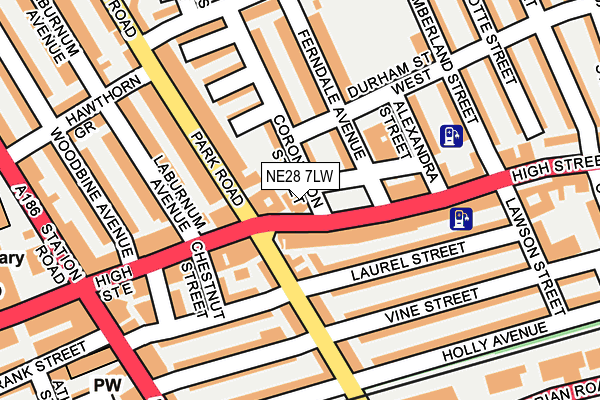
NE28 7LW is located in the Wallsend electoral ward, within the metropolitan district of North Tyneside and the English Parliamentary constituency of North Tyneside. The Sub Integrated Care Board (ICB) Location is NHS North East and North Cumbria ICB - 99C and the police force is Northumbria. This postcode has been in use since January 1980.


GetTheData
Source: OS OpenMap – Local (Ordnance Survey)
Source: OS VectorMap District (Ordnance Survey)
Licence: Open Government Licence (requires attribution)
| Easting | 430156 |
| Northing | 566469 |
| Latitude | 54.991900 |
| Longitude | -1.530220 |
GetTheData
Source: Open Postcode Geo
Licence: Open Government Licence
| Country | England |
| Postcode District | NE28 |
| ➜ NE28 open data dashboard ➜ See where NE28 is on a map ➜ Where is Wallsend? | |
GetTheData
Source: Land Registry Price Paid Data
Licence: Open Government Licence
Elevation or altitude of NE28 7LW as distance above sea level:
| Metres | Feet | |
|---|---|---|
| Elevation | 20m | 66ft |
Elevation is measured from the approximate centre of the postcode, to the nearest point on an OS contour line from OS Terrain 50, which has contour spacing of ten vertical metres.
➜ How high above sea level am I? Find the elevation of your current position using your device's GPS.
GetTheData
Source: Open Postcode Elevation
Licence: Open Government Licence
| Ward | Wallsend |
| Constituency | North Tyneside |
GetTheData
Source: ONS Postcode Database
Licence: Open Government Licence
| January 2024 | Anti-social behaviour | On or near Frank Street | 314m |
| January 2024 | Anti-social behaviour | On or near Frank Street | 314m |
| January 2024 | Other theft | On or near Frank Street | 314m |
| ➜ Get more crime data in our Crime section | |||
GetTheData
Source: data.police.uk
Licence: Open Government Licence
| High Street East - Park Road (High Street East) | Wallsend | 28m |
| High Street East - Laburnum Avenue (High Street East) | Wallsend | 140m |
| High Street East - Woodbine Avenue (High Street East) | Wallsend | 160m |
| High Street East-court Building (High Street East) | Wallsend | 234m |
| Station Road -town Centre (Station Road) | Wallsend | 262m |
| Wallsend (Tyne And Wear Metro Station) (Station Road) | Wallsend | 288m |
| Hadrian Road (Tyne And Wear Metro Station) (Hadrian Road) | Hadrian Road | 916m |
| Heworth Station | 4.8km |
| Manors Station | 5.2km |
| Brockley Whins Station | 5.7km |
GetTheData
Source: NaPTAN
Licence: Open Government Licence
GetTheData
Source: ONS Postcode Database
Licence: Open Government Licence


➜ Get more ratings from the Food Standards Agency
GetTheData
Source: Food Standards Agency
Licence: FSA terms & conditions
| Last Collection | |||
|---|---|---|---|
| Location | Mon-Fri | Sat | Distance |
| Park Road | 16:15 | 11:00 | 135m |
| Bodmin Close | 16:30 | 12:45 | 354m |
| Church Bank | 18:30 | 11:00 | 730m |
GetTheData
Source: Dracos
Licence: Creative Commons Attribution-ShareAlike
| Facility | Distance |
|---|---|
| Elite Fitness (Closed) Station Road, Wallsend Health and Fitness Gym | 230m |
| Richardson Dees Park North Road, Wallsend Outdoor Tennis Courts | 506m |
| Kicks Leisure (Wallsend) (Closed) Warwick Road, Wallsend Health and Fitness Gym, Swimming Pool, Studio | 528m |
GetTheData
Source: Active Places
Licence: Open Government Licence
| School | Phase of Education | Distance |
|---|---|---|
| Richardson Dees Primary School High Street East, Wallsend, NE28 7RT | Primary | 381m |
| Carville Primary School The Avenue, Wallsend, NE28 6AX | Primary | 709m |
| Burnside College St Peter's Road, Wallsend, NE28 7LQ | Secondary | 729m |
GetTheData
Source: Edubase
Licence: Open Government Licence
The below table lists the International Territorial Level (ITL) codes (formerly Nomenclature of Territorial Units for Statistics (NUTS) codes) and Local Administrative Units (LAU) codes for NE28 7LW:
| ITL 1 Code | Name |
|---|---|
| TLC | North East (England) |
| ITL 2 Code | Name |
| TLC2 | Northumberland, and Tyne and Wear |
| ITL 3 Code | Name |
| TLC22 | Tyneside |
| LAU 1 Code | Name |
| E08000022 | North Tyneside |
GetTheData
Source: ONS Postcode Directory
Licence: Open Government Licence
The below table lists the Census Output Area (OA), Lower Layer Super Output Area (LSOA), and Middle Layer Super Output Area (MSOA) for NE28 7LW:
| Code | Name | |
|---|---|---|
| OA | E00043523 | |
| LSOA | E01008573 | North Tyneside 029B |
| MSOA | E02001766 | North Tyneside 029 |
GetTheData
Source: ONS Postcode Directory
Licence: Open Government Licence
| NE28 7RH | High Street East | 52m |
| NE28 7NA | Ferndale Avenue | 63m |
| NE28 8PR | High Street East | 74m |
| NE28 7LU | Coronation Street | 76m |
| NE28 7QP | Park Road | 85m |
| NE28 7LT | Coronation Street | 97m |
| NE28 7LZ | Croft Avenue | 105m |
| NE28 6TG | Laurel Street | 115m |
| NE28 6PG | Laurel Street | 117m |
| NE28 6QX | Park Road | 119m |
GetTheData
Source: Open Postcode Geo; Land Registry Price Paid Data
Licence: Open Government Licence