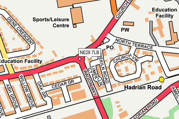
NE28 7LB lies on High Street East in Wallsend. NE28 7LB is located in the Wallsend electoral ward, within the metropolitan district of North Tyneside and the English Parliamentary constituency of North Tyneside. The Sub Integrated Care Board (ICB) Location is NHS North East and North Cumbria ICB - 99C and the police force is Northumbria. This postcode has been in use since January 1980.


GetTheData
Source: OS OpenMap – Local (Ordnance Survey)
Source: OS VectorMap District (Ordnance Survey)
Licence: Open Government Licence (requires attribution)
| Easting | 430840 |
| Northing | 566586 |
| Latitude | 54.992910 |
| Longitude | -1.519518 |
GetTheData
Source: Open Postcode Geo
Licence: Open Government Licence
| Street | High Street East |
| Town/City | Wallsend |
| Country | England |
| Postcode District | NE28 |
| ➜ NE28 open data dashboard ➜ See where NE28 is on a map ➜ Where is Wallsend? | |
GetTheData
Source: Land Registry Price Paid Data
Licence: Open Government Licence
Elevation or altitude of NE28 7LB as distance above sea level:
| Metres | Feet | |
|---|---|---|
| Elevation | 20m | 66ft |
Elevation is measured from the approximate centre of the postcode, to the nearest point on an OS contour line from OS Terrain 50, which has contour spacing of ten vertical metres.
➜ How high above sea level am I? Find the elevation of your current position using your device's GPS.
GetTheData
Source: Open Postcode Elevation
Licence: Open Government Licence
| Ward | Wallsend |
| Constituency | North Tyneside |
GetTheData
Source: ONS Postcode Database
Licence: Open Government Licence
| December 2023 | Criminal damage and arson | On or near Alnwick Street | 455m |
| November 2023 | Violence and sexual offences | On or near Alnwick Street | 455m |
| November 2023 | Vehicle crime | On or near Alnwick Street | 455m |
| ➜ High Street East crime map and outcomes | |||
GetTheData
Source: data.police.uk
Licence: Open Government Licence
| Church Bank-lodge Terrace (Lodge Terrace) | Hadrian Road | 67m |
| High Street East-dene Crescent (Wallsend High Street) | Wallsend | 112m |
| St Peters Road-school (St Peters Road) | Hadrian Road | 211m |
| St Peters Road-school (St Peters Road) | Hadrian Road | 223m |
| Hadrian Road-davy Bank (Hadrian Road) | Hadrian Road | 286m |
| Hadrian Road (Tyne And Wear Metro Station) (Hadrian Road) | Hadrian Road | 243m |
| Wallsend (Tyne And Wear Metro Station) (Station Road) | Wallsend | 898m |
| Heworth Station | 5.2km |
| Brockley Whins Station | 5.3km |
GetTheData
Source: NaPTAN
Licence: Open Government Licence
GetTheData
Source: ONS Postcode Database
Licence: Open Government Licence


➜ Get more ratings from the Food Standards Agency
GetTheData
Source: Food Standards Agency
Licence: FSA terms & conditions
| Last Collection | |||
|---|---|---|---|
| Location | Mon-Fri | Sat | Distance |
| Church Bank | 18:30 | 11:00 | 57m |
| South Terrace | 16:15 | 11:00 | 450m |
| Park Road | 16:15 | 11:00 | 711m |
GetTheData
Source: Dracos
Licence: Creative Commons Attribution-ShareAlike
| Facility | Distance |
|---|---|
| Hadrian Leisure Centre St. Peters Road, Wallsend Health and Fitness Gym, Swimming Pool | 155m |
| Burnside College St. Peters Road, Wallsend Health and Fitness Gym, Grass Pitches, Sports Hall, Artificial Grass Pitch, Studio | 216m |
| Elite Fitness (Closed) Station Road, Wallsend Health and Fitness Gym | 923m |
GetTheData
Source: Active Places
Licence: Open Government Licence
| School | Phase of Education | Distance |
|---|---|---|
| Burnside College St Peter's Road, Wallsend, NE28 7LQ | Secondary | 211m |
| Wallsend St Peter's CofE Aided Primary School North Terrace, Wallsend, NE28 6PY | Primary | 306m |
| Richardson Dees Primary School High Street East, Wallsend, NE28 7RT | Primary | 313m |
GetTheData
Source: Edubase
Licence: Open Government Licence
The below table lists the International Territorial Level (ITL) codes (formerly Nomenclature of Territorial Units for Statistics (NUTS) codes) and Local Administrative Units (LAU) codes for NE28 7LB:
| ITL 1 Code | Name |
|---|---|
| TLC | North East (England) |
| ITL 2 Code | Name |
| TLC2 | Northumberland, and Tyne and Wear |
| ITL 3 Code | Name |
| TLC22 | Tyneside |
| LAU 1 Code | Name |
| E08000022 | North Tyneside |
GetTheData
Source: ONS Postcode Directory
Licence: Open Government Licence
The below table lists the Census Output Area (OA), Lower Layer Super Output Area (LSOA), and Middle Layer Super Output Area (MSOA) for NE28 7LB:
| Code | Name | |
|---|---|---|
| OA | E00043516 | |
| LSOA | E01008572 | North Tyneside 029A |
| MSOA | E02001766 | North Tyneside 029 |
GetTheData
Source: ONS Postcode Directory
Licence: Open Government Licence
| NE28 7LF | 66m | |
| NE28 6QH | Limekiln Court | 94m |
| NE28 6PU | Church View | 103m |
| NE28 7JZ | High Street East | 109m |
| NE28 6PR | Cedar Grove | 115m |
| NE28 7LA | High Street East | 158m |
| NE28 6PS | Church View | 180m |
| NE28 7LG | St Peters Road | 196m |
| NE28 6PW | Oak Grove | 201m |
| NE28 7JY | High Street East | 224m |
GetTheData
Source: Open Postcode Geo; Land Registry Price Paid Data
Licence: Open Government Licence