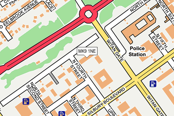
MK9 1NE is located in the Central Milton Keynes electoral ward, within the unitary authority of Milton Keynes and the English Parliamentary constituency of Milton Keynes North. The Sub Integrated Care Board (ICB) Location is NHS Bedfordshire, Luton and Milton Keynes ICB - M1J4Y and the police force is Thames Valley. This postcode has been in use since May 2005.


GetTheData
Source: OS OpenMap – Local (Ordnance Survey)
Source: OS VectorMap District (Ordnance Survey)
Licence: Open Government Licence (requires attribution)
| Easting | 484521 |
| Northing | 238745 |
| Latitude | 52.040672 |
| Longitude | -0.769131 |
GetTheData
Source: Open Postcode Geo
Licence: Open Government Licence
| Country | England |
| Postcode District | MK9 |
| ➜ MK9 open data dashboard ➜ See where MK9 is on a map | |
GetTheData
Source: Land Registry Price Paid Data
Licence: Open Government Licence
Elevation or altitude of MK9 1NE as distance above sea level:
| Metres | Feet | |
|---|---|---|
| Elevation | 90m | 295ft |
Elevation is measured from the approximate centre of the postcode, to the nearest point on an OS contour line from OS Terrain 50, which has contour spacing of ten vertical metres.
➜ How high above sea level am I? Find the elevation of your current position using your device's GPS.
GetTheData
Source: Open Postcode Elevation
Licence: Open Government Licence
| Ward | Central Milton Keynes |
| Constituency | Milton Keynes North |
GetTheData
Source: ONS Postcode Database
Licence: Open Government Licence
| March 2023 | Burglary | On or near Clapham Place | 340m |
| February 2023 | Violence and sexual offences | On or near Clapham Place | 340m |
| November 2022 | Public order | On or near Clapham Place | 340m |
| ➜ Get more crime data in our Crime section | |||
GetTheData
Source: data.police.uk
Licence: Open Government Licence
| Santander House (Midsummer Boulevard) | Central Milton Keynes | 394m |
| Santander House (Midsummer Boulevard) | Central Milton Keynes | 401m |
| The Countryman Ph (Bradwell Common Boulevard) | Bradwell Common | 409m |
| Santander House (Midsummer Boulevard) | Central Milton Keynes | 413m |
| Santander House (Midsummer Boulevard) | Central Milton Keynes | 418m |
| Milton Keynes Central Station | 0.8km |
| Wolverton Station | 3.7km |
| Fenny Stratford Station | 5.8km |
GetTheData
Source: NaPTAN
Licence: Open Government Licence
GetTheData
Source: ONS Postcode Database
Licence: Open Government Licence


➜ Get more ratings from the Food Standards Agency
GetTheData
Source: Food Standards Agency
Licence: FSA terms & conditions
| Last Collection | |||
|---|---|---|---|
| Location | Mon-Fri | Sat | Distance |
| Grant Thornton House | 18:30 | 205m | |
| Bank House Midsummer Boulevard | 18:50 | 12:00 | 382m |
| Ashton House Silbury Boulevard | 18:30 | 12:00 | 398m |
GetTheData
Source: Dracos
Licence: Creative Commons Attribution-ShareAlike
| Facility | Distance |
|---|---|
| Summerfield School Downley Avenue, Bradwell Common, Milton Keynes Grass Pitches, Sports Hall | 551m |
| Bannatyne Health Club (Milton Keynes) Midsummer Boulevard, Milton Keynes Swimming Pool, Health and Fitness Gym, Studio | 626m |
| Sport Central Elder Gate, Central Milton Keynes, Milton Keynes Artificial Grass Pitch, Outdoor Tennis Courts | 642m |
GetTheData
Source: Active Places
Licence: Open Government Licence
| School | Phase of Education | Distance |
|---|---|---|
| Summerfield School Downley Avenue, Bradwell Common, Milton Keynes, MK13 8PG | Primary | 551m |
| Germander Park School 1 Germander Place, Conniburrow, Milton Keynes, MK14 7DU | Primary | 996m |
| Heelands School Glovers Lane, Heelands, Heelands School, Milton Keynes, MK13 7QL | Primary | 1.3km |
GetTheData
Source: Edubase
Licence: Open Government Licence
The below table lists the International Territorial Level (ITL) codes (formerly Nomenclature of Territorial Units for Statistics (NUTS) codes) and Local Administrative Units (LAU) codes for MK9 1NE:
| ITL 1 Code | Name |
|---|---|
| TLJ | South East (England) |
| ITL 2 Code | Name |
| TLJ1 | Berkshire, Buckinghamshire and Oxfordshire |
| ITL 3 Code | Name |
| TLJ12 | Milton Keynes |
| LAU 1 Code | Name |
| E06000042 | Milton Keynes |
GetTheData
Source: ONS Postcode Directory
Licence: Open Government Licence
The below table lists the Census Output Area (OA), Lower Layer Super Output Area (LSOA), and Middle Layer Super Output Area (MSOA) for MK9 1NE:
| Code | Name | |
|---|---|---|
| OA | E00175394 | |
| LSOA | E01033500 | Milton Keynes 014F |
| MSOA | E02003472 | Milton Keynes 014 |
GetTheData
Source: ONS Postcode Directory
Licence: Open Government Licence
| MK9 3PL | North Row | 102m |
| MK9 3LZ | North Third Street | 141m |
| MK9 3LQ | North Row | 149m |
| MK9 1LZ | Silbury Boulevard | 150m |
| MK9 1AY | North Row | 196m |
| MK9 1BZ | North Second Street | 201m |
| MK13 8RL | Hadley Place | 214m |
| MK13 8RE | Eel Brook Avenue | 220m |
| MK13 8RJ | Hadley Place | 226m |
| MK13 8RH | Streatham Place | 263m |
GetTheData
Source: Open Postcode Geo; Land Registry Price Paid Data
Licence: Open Government Licence