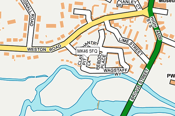
MK46 5FQ lies on Clay Pit Lane in Olney. MK46 5FQ is located in the Olney electoral ward, within the unitary authority of Milton Keynes and the English Parliamentary constituency of Milton Keynes North. The Sub Integrated Care Board (ICB) Location is NHS Bedfordshire, Luton and Milton Keynes ICB - M1J4Y and the police force is Thames Valley. This postcode has been in use since July 2005.


GetTheData
Source: OS OpenMap – Local (Ordnance Survey)
Source: OS VectorMap District (Ordnance Survey)
Licence: Open Government Licence (requires attribution)
| Easting | 488681 |
| Northing | 251055 |
| Latitude | 52.150668 |
| Longitude | -0.705297 |
GetTheData
Source: Open Postcode Geo
Licence: Open Government Licence
| Street | Clay Pit Lane |
| Town/City | Olney |
| Country | England |
| Postcode District | MK46 |
| ➜ MK46 open data dashboard ➜ See where MK46 is on a map ➜ Where is Olney? | |
GetTheData
Source: Land Registry Price Paid Data
Licence: Open Government Licence
Elevation or altitude of MK46 5FQ as distance above sea level:
| Metres | Feet | |
|---|---|---|
| Elevation | 50m | 164ft |
Elevation is measured from the approximate centre of the postcode, to the nearest point on an OS contour line from OS Terrain 50, which has contour spacing of ten vertical metres.
➜ How high above sea level am I? Find the elevation of your current position using your device's GPS.
GetTheData
Source: Open Postcode Elevation
Licence: Open Government Licence
| Ward | Olney |
| Constituency | Milton Keynes North |
GetTheData
Source: ONS Postcode Database
Licence: Open Government Licence
| October 2022 | Vehicle crime | On or near Orchard Rise | 442m |
| July 2022 | Criminal damage and arson | On or near The Pyghtle | 298m |
| July 2022 | Criminal damage and arson | On or near The Pyghtle | 298m |
| ➜ Clay Pit Lane crime map and outcomes | |||
GetTheData
Source: data.police.uk
Licence: Open Government Licence
| Weston Road | Olney | 155m |
| Weston Road | Olney | 257m |
| The Bull (High Street) | Olney | 326m |
| Spinney Hill Road | Olney | 327m |
| The Bull (High Street) | Olney | 340m |
GetTheData
Source: NaPTAN
Licence: Open Government Licence
| Percentage of properties with Next Generation Access | 100.0% |
| Percentage of properties with Superfast Broadband | 100.0% |
| Percentage of properties with Ultrafast Broadband | 0.0% |
| Percentage of properties with Full Fibre Broadband | 0.0% |
Superfast Broadband is between 30Mbps and 300Mbps
Ultrafast Broadband is > 300Mbps
| Percentage of properties unable to receive 2Mbps | 0.0% |
| Percentage of properties unable to receive 5Mbps | 0.0% |
| Percentage of properties unable to receive 10Mbps | 0.0% |
| Percentage of properties unable to receive 30Mbps | 0.0% |
GetTheData
Source: Ofcom
Licence: Ofcom Terms of Use (requires attribution)
GetTheData
Source: ONS Postcode Database
Licence: Open Government Licence


➜ Get more ratings from the Food Standards Agency
GetTheData
Source: Food Standards Agency
Licence: FSA terms & conditions
| Last Collection | |||
|---|---|---|---|
| Location | Mon-Fri | Sat | Distance |
| Weston Road | 16:00 | 09:30 | 245m |
| Market Place | 17:30 | 11:00 | 321m |
| Fourboys Market Place | 17:30 | 11:00 | 384m |
GetTheData
Source: Dracos
Licence: Creative Commons Attribution-ShareAlike
| Facility | Distance |
|---|---|
| Allotment Field East Street, Olney Grass Pitches | 761m |
| Olney Recreation Ground East Street, Olney Grass Pitches, Outdoor Tennis Courts | 942m |
| Ousedale School (Olney Campus) Aspreys, Olney Sports Hall, Grass Pitches, Outdoor Tennis Courts, Health and Fitness Gym | 966m |
GetTheData
Source: Active Places
Licence: Open Government Licence
| School | Phase of Education | Distance |
|---|---|---|
| Olney Infant Academy Spinney Hill Road, Olney, MK46 5AD | Primary | 503m |
| Olney Middle School Yardley Road, Olney, MK46 5DZ | Primary | 1.2km |
| Newton Blossomville Church of England School Newton Blossomville, Turvey, Bedford, MK43 8AL | Primary | 3.9km |
GetTheData
Source: Edubase
Licence: Open Government Licence
The below table lists the International Territorial Level (ITL) codes (formerly Nomenclature of Territorial Units for Statistics (NUTS) codes) and Local Administrative Units (LAU) codes for MK46 5FQ:
| ITL 1 Code | Name |
|---|---|
| TLJ | South East (England) |
| ITL 2 Code | Name |
| TLJ1 | Berkshire, Buckinghamshire and Oxfordshire |
| ITL 3 Code | Name |
| TLJ12 | Milton Keynes |
| LAU 1 Code | Name |
| E06000042 | Milton Keynes |
GetTheData
Source: ONS Postcode Directory
Licence: Open Government Licence
The below table lists the Census Output Area (OA), Lower Layer Super Output Area (LSOA), and Middle Layer Super Output Area (MSOA) for MK46 5FQ:
| Code | Name | |
|---|---|---|
| OA | E00084756 | |
| LSOA | E01016799 | Milton Keynes 001D |
| MSOA | E02003459 | Milton Keynes 001 |
GetTheData
Source: ONS Postcode Directory
Licence: Open Government Licence
| MK46 5FE | Chantry Rise | 42m |
| MK46 5FL | Pebody Place | 45m |
| MK46 5FB | Wagstaff Way | 55m |
| MK46 5BE | Weston Road | 92m |
| MK46 5FF | Stonemasons Close | 104m |
| MK46 5FD | Wagstaff Way | 150m |
| MK46 5BA | Lime Street | 160m |
| MK46 5BQ | Weston Road | 166m |
| MK46 5BG | Oakdown Crescent | 168m |
| MK46 5BD | Weston Road | 177m |
GetTheData
Source: Open Postcode Geo; Land Registry Price Paid Data
Licence: Open Government Licence