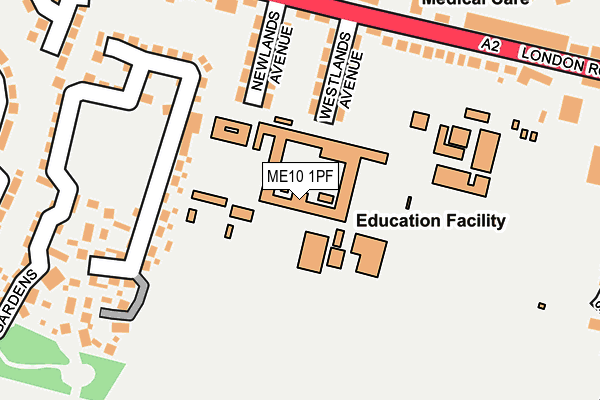
ME10 1PF is located in the Borden and Grove Park electoral ward, within the local authority district of Swale and the English Parliamentary constituency of Sittingbourne and Sheppey. The Sub Integrated Care Board (ICB) Location is NHS Kent and Medway ICB - 91Q and the police force is Kent. This postcode has been in use since January 1980.


GetTheData
Source: OS OpenMap – Local (Ordnance Survey)
Source: OS VectorMap District (Ordnance Survey)
Licence: Open Government Licence (requires attribution)
| Easting | 588904 |
| Northing | 163864 |
| Latitude | 51.342466 |
| Longitude | 0.710876 |
GetTheData
Source: Open Postcode Geo
Licence: Open Government Licence
| Country | England |
| Postcode District | ME10 |
| ➜ ME10 open data dashboard ➜ See where ME10 is on a map ➜ Where is Sittingbourne? | |
GetTheData
Source: Land Registry Price Paid Data
Licence: Open Government Licence
Elevation or altitude of ME10 1PF as distance above sea level:
| Metres | Feet | |
|---|---|---|
| Elevation | 30m | 98ft |
Elevation is measured from the approximate centre of the postcode, to the nearest point on an OS contour line from OS Terrain 50, which has contour spacing of ten vertical metres.
➜ How high above sea level am I? Find the elevation of your current position using your device's GPS.
GetTheData
Source: Open Postcode Elevation
Licence: Open Government Licence
| Ward | Borden And Grove Park |
| Constituency | Sittingbourne And Sheppey |
GetTheData
Source: ONS Postcode Database
Licence: Open Government Licence
| June 2023 | Shoplifting | On or near Somerset Close | 327m |
| June 2023 | Shoplifting | On or near Somerset Close | 327m |
| June 2023 | Shoplifting | On or near Somerset Close | 327m |
| ➜ Get more crime data in our Crime section | |||
GetTheData
Source: data.police.uk
Licence: Open Government Licence
| The Billet (London Road) | Milton Regis | 195m |
| Westlands School | Milton Regis | 205m |
| The Billet (London Road) | Milton Regis | 208m |
| Sandford Road (London Road) | Key Street | 312m |
| Keyways Stores (London Road) | Milton Regis | 339m |
| Sittingbourne Station | 1.7km |
| Kemsley Station | 2.8km |
| Newington Station | 3.2km |
GetTheData
Source: NaPTAN
Licence: Open Government Licence
GetTheData
Source: ONS Postcode Database
Licence: Open Government Licence


➜ Get more ratings from the Food Standards Agency
GetTheData
Source: Food Standards Agency
Licence: FSA terms & conditions
| Last Collection | |||
|---|---|---|---|
| Location | Mon-Fri | Sat | Distance |
| Wises Lane | 17:30 | 11:30 | 496m |
| Gadby Road (Ex P O) | 17:30 | 11:30 | 537m |
| Borden Lane | 17:15 | 11:45 | 630m |
GetTheData
Source: Dracos
Licence: Creative Commons Attribution-ShareAlike
| Facility | Distance |
|---|---|
| Westlands School Westlands Avenue, Sittingbourne Sports Hall, Grass Pitches, Artificial Grass Pitch | 0m |
| Reynolds Fitness Spa Sittingbourne London Road, Sittingbourne Health and Fitness Gym, Swimming Pool, Studio | 286m |
| Gore Court Cricket Club (The Grove) London Road, Sittingbourne Grass Pitches | 506m |
GetTheData
Source: Active Places
Licence: Open Government Licence
| School | Phase of Education | Distance |
|---|---|---|
| Westlands School Westlands Avenue, Sittingbourne, ME10 1PF | Secondary | 0m |
| Grove Park Primary School Hilton Drive, Sittingbourne, ME10 1PT | Primary | 744m |
| Aspire School Vellum Drive, Sittingbourne, ME10 5DA | Not applicable | 818m |
GetTheData
Source: Edubase
Licence: Open Government Licence
The below table lists the International Territorial Level (ITL) codes (formerly Nomenclature of Territorial Units for Statistics (NUTS) codes) and Local Administrative Units (LAU) codes for ME10 1PF:
| ITL 1 Code | Name |
|---|---|
| TLJ | South East (England) |
| ITL 2 Code | Name |
| TLJ4 | Kent |
| ITL 3 Code | Name |
| TLJ43 | Kent Thames Gateway |
| LAU 1 Code | Name |
| E07000113 | Swale |
GetTheData
Source: ONS Postcode Directory
Licence: Open Government Licence
The below table lists the Census Output Area (OA), Lower Layer Super Output Area (LSOA), and Middle Layer Super Output Area (MSOA) for ME10 1PF:
| Code | Name | |
|---|---|---|
| OA | E00124703 | |
| LSOA | E01024569 | Swale 012C |
| MSOA | E02005126 | Swale 012 |
GetTheData
Source: ONS Postcode Directory
Licence: Open Government Licence
| ME10 1PG | Westlands Avenue | 135m |
| ME10 1PH | Newlands Avenue | 149m |
| ME10 1GB | Maylam Gardens | 214m |
| ME10 1QR | Wilton Terrace | 220m |
| ME10 1PW | London Road | 236m |
| ME10 1PA | London Road | 236m |
| ME10 1GE | Greenlees Close | 243m |
| ME10 1GD | Micketts Gardens | 245m |
| ME10 1QA | London Road | 254m |
| ME10 1GA | Maylam Gardens | 257m |
GetTheData
Source: Open Postcode Geo; Land Registry Price Paid Data
Licence: Open Government Licence