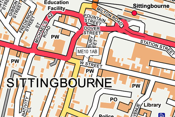
ME10 1AB lies on West Street in Sittingbourne. ME10 1AB is located in the Chalkwell electoral ward, within the local authority district of Swale and the English Parliamentary constituency of Sittingbourne and Sheppey. The Sub Integrated Care Board (ICB) Location is NHS Kent and Medway ICB - 91Q and the police force is Kent. This postcode has been in use since January 1980.


GetTheData
Source: OS OpenMap – Local (Ordnance Survey)
Source: OS VectorMap District (Ordnance Survey)
Licence: Open Government Licence (requires attribution)
| Easting | 590422 |
| Northing | 163727 |
| Latitude | 51.340729 |
| Longitude | 0.732571 |
GetTheData
Source: Open Postcode Geo
Licence: Open Government Licence
| Street | West Street |
| Town/City | Sittingbourne |
| Country | England |
| Postcode District | ME10 |
➜ See where ME10 is on a map ➜ Where is Sittingbourne? | |
GetTheData
Source: Land Registry Price Paid Data
Licence: Open Government Licence
Elevation or altitude of ME10 1AB as distance above sea level:
| Metres | Feet | |
|---|---|---|
| Elevation | 20m | 66ft |
Elevation is measured from the approximate centre of the postcode, to the nearest point on an OS contour line from OS Terrain 50, which has contour spacing of ten vertical metres.
➜ How high above sea level am I? Find the elevation of your current position using your device's GPS.
GetTheData
Source: Open Postcode Elevation
Licence: Open Government Licence
| Ward | Chalkwell |
| Constituency | Sittingbourne And Sheppey |
GetTheData
Source: ONS Postcode Database
Licence: Open Government Licence
| High Street | Sittingbourne | 149m |
| Railway Station (Railway Station Forecourt) | Sittingbourne | 189m |
| Cockleshell Walk (St Michael's Road) | Sittingbourne | 191m |
| Forum Shopping Centre (Station Street) | Sittingbourne | 192m |
| Railway Station (Railway Station Forecourt) | Sittingbourne | 198m |
| Sittingbourne Station | 0.2km |
| Kemsley Station | 2.4km |
| Newington Station | 4.7km |
GetTheData
Source: NaPTAN
Licence: Open Government Licence
GetTheData
Source: ONS Postcode Database
Licence: Open Government Licence


➜ Get more ratings from the Food Standards Agency
GetTheData
Source: Food Standards Agency
Licence: FSA terms & conditions
| Last Collection | |||
|---|---|---|---|
| Location | Mon-Fri | Sat | Distance |
| Park Road (Bottom Box) | 17:30 | 11:30 | 60m |
| Railway Station | 17:30 | 12:00 | 208m |
| Sittingbourne P.o. Meter Box | 212m | ||
GetTheData
Source: Dracos
Licence: Creative Commons Attribution-ShareAlike
The below table lists the International Territorial Level (ITL) codes (formerly Nomenclature of Territorial Units for Statistics (NUTS) codes) and Local Administrative Units (LAU) codes for ME10 1AB:
| ITL 1 Code | Name |
|---|---|
| TLJ | South East (England) |
| ITL 2 Code | Name |
| TLJ4 | Kent |
| ITL 3 Code | Name |
| TLJ43 | Kent Thames Gateway |
| LAU 1 Code | Name |
| E07000113 | Swale |
GetTheData
Source: ONS Postcode Directory
Licence: Open Government Licence
The below table lists the Census Output Area (OA), Lower Layer Super Output Area (LSOA), and Middle Layer Super Output Area (MSOA) for ME10 1AB:
| Code | Name | |
|---|---|---|
| OA | E00124882 | |
| LSOA | E01024608 | Swale 010E |
| MSOA | E02005124 | Swale 010 |
GetTheData
Source: ONS Postcode Directory
Licence: Open Government Licence
| ME10 1AW | West Street | 16m |
| ME10 1AP | West Street | 37m |
| ME10 1AJ | West Street | 68m |
| ME10 3DU | Station Street | 71m |
| ME10 3EE | Pembury Street | 83m |
| ME10 1AL | West Street | 97m |
| ME10 4AQ | High Street | 98m |
| ME10 4PL | High Street | 111m |
| ME10 1DR | Park Road | 125m |
| ME10 1AF | Cloisters | 132m |
GetTheData
Source: Open Postcode Geo; Land Registry Price Paid Data
Licence: Open Government Licence