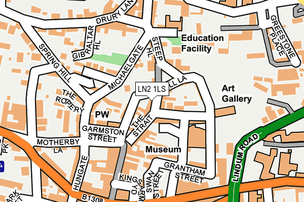
LN2 1LS lies on Steep Hill in Lincoln. LN2 1LS is located in the Carholme electoral ward, within the local authority district of Lincoln and the English Parliamentary constituency of Lincoln. The Sub Integrated Care Board (ICB) Location is NHS Lincolnshire ICB - 71E and the police force is Lincolnshire. This postcode has been in use since January 1980.


GetTheData
Source: OS OpenMap – Local (Ordnance Survey)
Source: OS VectorMap District (Ordnance Survey)
Licence: Open Government Licence (requires attribution)
| Easting | 497642 |
| Northing | 371584 |
| Latitude | 53.232327 |
| Longitude | -0.538646 |
GetTheData
Source: Open Postcode Geo
Licence: Open Government Licence
| Street | Steep Hill |
| Town/City | Lincoln |
| Country | England |
| Postcode District | LN2 |
| ➜ LN2 open data dashboard ➜ See where LN2 is on a map ➜ Where is Lincoln? | |
GetTheData
Source: Land Registry Price Paid Data
Licence: Open Government Licence
Elevation or altitude of LN2 1LS as distance above sea level:
| Metres | Feet | |
|---|---|---|
| Elevation | 30m | 98ft |
Elevation is measured from the approximate centre of the postcode, to the nearest point on an OS contour line from OS Terrain 50, which has contour spacing of ten vertical metres.
➜ How high above sea level am I? Find the elevation of your current position using your device's GPS.
GetTheData
Source: Open Postcode Elevation
Licence: Open Government Licence
| Ward | Carholme |
| Constituency | Lincoln |
GetTheData
Source: ONS Postcode Database
Licence: Open Government Licence
| January 2024 | Anti-social behaviour | On or near Parking Area | 235m |
| January 2024 | Anti-social behaviour | On or near Parking Area | 235m |
| January 2024 | Public order | On or near Parking Area | 235m |
| ➜ Get more crime data in our Crime section | |||
GetTheData
Source: data.police.uk
Licence: Open Government Licence
| The Collection (Danes Terrace) | Lincoln | 91m |
| St Martins Lane | Lincoln | 120m |
| Cathedral (Minster Yard) | Lincoln | 210m |
| Constitutional Club (Silver Street) | Lincoln | 231m |
| Tourist Information Centre (Castle Hill) | Lincoln | 236m |
| Lincoln Central Station | 0.7km |
| Hykeham Station | 5.8km |
GetTheData
Source: NaPTAN
Licence: Open Government Licence
| Percentage of properties with Next Generation Access | 100.0% |
| Percentage of properties with Superfast Broadband | 100.0% |
| Percentage of properties with Ultrafast Broadband | 0.0% |
| Percentage of properties with Full Fibre Broadband | 0.0% |
Superfast Broadband is between 30Mbps and 300Mbps
Ultrafast Broadband is > 300Mbps
| Percentage of properties unable to receive 2Mbps | 0.0% |
| Percentage of properties unable to receive 5Mbps | 0.0% |
| Percentage of properties unable to receive 10Mbps | 0.0% |
| Percentage of properties unable to receive 30Mbps | 0.0% |
GetTheData
Source: Ofcom
Licence: Ofcom Terms of Use (requires attribution)
GetTheData
Source: ONS Postcode Database
Licence: Open Government Licence


➜ Get more ratings from the Food Standards Agency
GetTheData
Source: Food Standards Agency
Licence: FSA terms & conditions
| Last Collection | |||
|---|---|---|---|
| Location | Mon-Fri | Sat | Distance |
| Lindum Road | 18:30 | 11:45 | 206m |
| Corporation Street | 18:30 | 11:30 | 212m |
| Bailgate Post Office | 18:45 | 12:15 | 227m |
GetTheData
Source: Dracos
Licence: Creative Commons Attribution-ShareAlike
| Facility | Distance |
|---|---|
| Lincoln College (Closed) Monks Road, Lincoln Sports Hall, Health and Fitness Gym, Squash Courts | 328m |
| Lincoln Minster School Upper Lindum Street, Lincoln Sports Hall | 459m |
| Lincoln College (Deans Sport And Leisure) Monks Road, Lincoln Health and Fitness Gym, Sports Hall, Studio, Squash Courts | 472m |
GetTheData
Source: Active Places
Licence: Open Government Licence
| School | Phase of Education | Distance |
|---|---|---|
| Lincoln UTC Lindum Road, Lincoln, LN2 1PF | Secondary | 270m |
| Lincoln College Monks Road, Lincoln, LN2 5HQ | 16 plus | 463m |
| Lincolnshire Secure Unit Care of: Lincolnshire County Council, County Offices, Newland, Lincoln, LN1 1YL | Not applicable | 490m |
GetTheData
Source: Edubase
Licence: Open Government Licence
The below table lists the International Territorial Level (ITL) codes (formerly Nomenclature of Territorial Units for Statistics (NUTS) codes) and Local Administrative Units (LAU) codes for LN2 1LS:
| ITL 1 Code | Name |
|---|---|
| TLF | East Midlands (England) |
| ITL 2 Code | Name |
| TLF3 | Lincolnshire |
| ITL 3 Code | Name |
| TLF30 | Lincolnshire CC |
| LAU 1 Code | Name |
| E07000138 | Lincoln |
GetTheData
Source: ONS Postcode Directory
Licence: Open Government Licence
The below table lists the Census Output Area (OA), Lower Layer Super Output Area (LSOA), and Middle Layer Super Output Area (MSOA) for LN2 1LS:
| Code | Name | |
|---|---|---|
| OA | E00132752 | |
| LSOA | E01026143 | Lincoln 005B |
| MSOA | E02005446 | Lincoln 005 |
GetTheData
Source: ONS Postcode Directory
Licence: Open Government Licence
| LN2 1LR | Steep Hill | 28m |
| LN2 1PG | Neustadt Court | 41m |
| LN2 1JA | St Martins Street | 47m |
| LN2 1NA | Well Lane | 51m |
| LN1 3BT | Michaelgate | 60m |
| LN2 1LP | Danes Terrace | 60m |
| LN2 1JD | The Strait | 64m |
| LN2 1NB | Danes Cottages | 72m |
| LN1 3ER | St Cuthberts Court | 73m |
| LN2 1LT | Steep Hill | 80m |
GetTheData
Source: Open Postcode Geo; Land Registry Price Paid Data
Licence: Open Government Licence