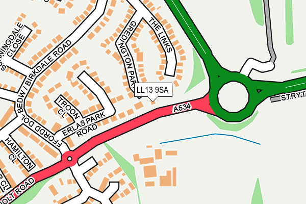
LL13 9SA lies on Holt Road in Llan Y Pwll, Wrexham. LL13 9SA is located in the Holt electoral ward, within the unitary authority of Wrexham and the Welsh Parliamentary constituency of Wrexham. The Local Health Board is Betsi Cadwaladr University and the police force is North Wales. This postcode has been in use since January 1980.


GetTheData
Source: OS OpenMap – Local (Ordnance Survey)
Source: OS VectorMap District (Ordnance Survey)
Licence: Open Government Licence (requires attribution)
| Easting | 335932 |
| Northing | 351874 |
| Latitude | 53.060272 |
| Longitude | -2.957433 |
GetTheData
Source: Open Postcode Geo
Licence: Open Government Licence
| Street | Holt Road |
| Locality | Llan Y Pwll |
| Town/City | Wrexham |
| Country | Wales |
| Postcode District | LL13 |
➜ See where LL13 is on a map | |
GetTheData
Source: Land Registry Price Paid Data
Licence: Open Government Licence
Elevation or altitude of LL13 9SA as distance above sea level:
| Metres | Feet | |
|---|---|---|
| Elevation | 70m | 230ft |
Elevation is measured from the approximate centre of the postcode, to the nearest point on an OS contour line from OS Terrain 50, which has contour spacing of ten vertical metres.
➜ How high above sea level am I? Find the elevation of your current position using your device's GPS.
GetTheData
Source: Open Postcode Elevation
Licence: Open Government Licence
| Ward | Holt |
| Constituency | Wrexham |
GetTheData
Source: ONS Postcode Database
Licence: Open Government Licence
| Birkdale Road | Borras | 259m |
| Birkdale Road | Borras | 276m |
| Conningsby Court (Birkdale Road) | Borras | 310m |
| Conningsby Court (Birkdale Road) | Borras | 315m |
| St Mellion Crescent | Borras | 420m |
| Wrexham Central Station | 3.2km |
| Wrexham General Station | 3.2km |
| Gwersyllt Station | 4.3km |
GetTheData
Source: NaPTAN
Licence: Open Government Licence
| Percentage of properties with Next Generation Access | 100.0% |
| Percentage of properties with Superfast Broadband | 85.7% |
| Percentage of properties with Ultrafast Broadband | 71.4% |
| Percentage of properties with Full Fibre Broadband | 71.4% |
Superfast Broadband is between 30Mbps and 300Mbps
Ultrafast Broadband is > 300Mbps
| Percentage of properties unable to receive 2Mbps | 0.0% |
| Percentage of properties unable to receive 5Mbps | 14.3% |
| Percentage of properties unable to receive 10Mbps | 14.3% |
| Percentage of properties unable to receive 30Mbps | 14.3% |
GetTheData
Source: Ofcom
Licence: Ofcom Terms of Use (requires attribution)
GetTheData
Source: ONS Postcode Database
Licence: Open Government Licence


➜ Get more ratings from the Food Standards Agency
GetTheData
Source: Food Standards Agency
Licence: FSA terms & conditions
| Last Collection | |||
|---|---|---|---|
| Location | Mon-Fri | Sat | Distance |
| Goulbourne Park | 17:15 | 11:30 | 313m |
| Rhosnesni Post Office | 17:00 | 11:30 | 1,020m |
| Fenwick Drive | 16:00 | 12:00 | 1,325m |
GetTheData
Source: Dracos
Licence: Creative Commons Attribution-ShareAlike
The below table lists the International Territorial Level (ITL) codes (formerly Nomenclature of Territorial Units for Statistics (NUTS) codes) and Local Administrative Units (LAU) codes for LL13 9SA:
| ITL 1 Code | Name |
|---|---|
| TLL | Wales |
| ITL 2 Code | Name |
| TLL2 | East Wales |
| ITL 3 Code | Name |
| TLL23 | Flintshire and Wrexham |
| LAU 1 Code | Name |
| W06000006 | Wrexham |
GetTheData
Source: ONS Postcode Directory
Licence: Open Government Licence
The below table lists the Census Output Area (OA), Lower Layer Super Output Area (LSOA), and Middle Layer Super Output Area (MSOA) for LL13 9SA:
| Code | Name | |
|---|---|---|
| OA | W00002047 | |
| LSOA | W01000383 | Wrexham 020A |
| MSOA | W02000420 | Wrexham 020 |
GetTheData
Source: ONS Postcode Directory
Licence: Open Government Licence
| LL13 9PZ | The Links | 156m |
| LL13 9DQ | Gredington Close | 193m |
| LL13 9QT | Erlas Park Road | 317m |
| LL13 9QY | Wentworth Rise | 319m |
| LL13 9JY | Mile Barn Road | 320m |
| LL13 9QW | Coningsby Court | 362m |
| LL13 9GT | Plassey Close | 373m |
| LL13 9QX | Troon Close | 385m |
| LL13 9GU | Belfry Close | 390m |
| LL13 9QQ | Cosford Close | 393m |
GetTheData
Source: Open Postcode Geo; Land Registry Price Paid Data
Licence: Open Government Licence