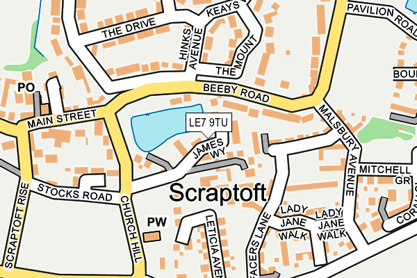
LE7 9TU lies on James Way in Scraptoft, Leicester. LE7 9TU is located in the Thurnby & Houghton electoral ward, within the local authority district of Harborough and the English Parliamentary constituency of Rutland and Melton. The Sub Integrated Care Board (ICB) Location is NHS Leicester, Leicestershire and Rutland ICB - 03W and the police force is Leicestershire. This postcode has been in use since March 2016.


GetTheData
Source: OS OpenMap – Local (Ordnance Survey)
Source: OS VectorMap District (Ordnance Survey)
Licence: Open Government Licence (requires attribution)
| Easting | 464848 |
| Northing | 305715 |
| Latitude | 52.645325 |
| Longitude | -1.042990 |
GetTheData
Source: Open Postcode Geo
Licence: Open Government Licence
| Street | James Way |
| Locality | Scraptoft |
| Town/City | Leicester |
| Country | England |
| Postcode District | LE7 |
➜ See where LE7 is on a map ➜ Where is Leicester? | |
GetTheData
Source: Land Registry Price Paid Data
Licence: Open Government Licence
Elevation or altitude of LE7 9TU as distance above sea level:
| Metres | Feet | |
|---|---|---|
| Elevation | 110m | 361ft |
Elevation is measured from the approximate centre of the postcode, to the nearest point on an OS contour line from OS Terrain 50, which has contour spacing of ten vertical metres.
➜ How high above sea level am I? Find the elevation of your current position using your device's GPS.
GetTheData
Source: Open Postcode Elevation
Licence: Open Government Licence
| Ward | Thurnby & Houghton |
| Constituency | Rutland And Melton |
GetTheData
Source: ONS Postcode Database
Licence: Open Government Licence
2022 24 OCT £608,500 |
2021 22 OCT £380,000 |
2021 29 JUN £600,000 |
2020 15 MAY £460,000 |
2020 20 MAR £500,000 |
2017 26 MAY £549,995 |
7, JAMES WAY, SCRAPTOFT, LEICESTER, LE7 9TU 2017 31 MAR £460,000 |
11, JAMES WAY, SCRAPTOFT, LEICESTER, LE7 9TU 2017 6 JAN £469,995 |
13, JAMES WAY, SCRAPTOFT, LEICESTER, LE7 9TU 2016 25 NOV £339,500 |
2016 30 SEP £335,500 |
GetTheData
Source: HM Land Registry Price Paid Data
Licence: Contains HM Land Registry data © Crown copyright and database right 2025. This data is licensed under the Open Government Licence v3.0.
| Hinks Avenue (Beeby Road) | Scraptoft | 67m |
| Stocks Road (Church Hill) | Scraptoft | 116m |
| Mitchell Grove (Malsbury Avenue) | Scraptoft | 203m |
| Southfield Close (Station Lane) | Scraptoft | 267m |
| Southfield Close (Station Lane) | Scraptoft | 276m |
GetTheData
Source: NaPTAN
Licence: Open Government Licence
| Percentage of properties with Next Generation Access | 100.0% |
| Percentage of properties with Superfast Broadband | 100.0% |
| Percentage of properties with Ultrafast Broadband | 0.0% |
| Percentage of properties with Full Fibre Broadband | 0.0% |
Superfast Broadband is between 30Mbps and 300Mbps
Ultrafast Broadband is > 300Mbps
| Median download speed | 51.8Mbps |
| Average download speed | 46.4Mbps |
| Maximum download speed | 72.14Mbps |
| Median upload speed | 13.9Mbps |
| Average upload speed | 12.3Mbps |
| Maximum upload speed | 20.00Mbps |
| Percentage of properties unable to receive 2Mbps | 0.0% |
| Percentage of properties unable to receive 5Mbps | 0.0% |
| Percentage of properties unable to receive 10Mbps | 0.0% |
| Percentage of properties unable to receive 30Mbps | 0.0% |
GetTheData
Source: Ofcom
Licence: Ofcom Terms of Use (requires attribution)
GetTheData
Source: ONS Postcode Database
Licence: Open Government Licence


➜ Get more ratings from the Food Standards Agency
GetTheData
Source: Food Standards Agency
Licence: FSA terms & conditions
| Last Collection | |||
|---|---|---|---|
| Location | Mon-Fri | Sat | Distance |
| Main Street | 16:45 | 09:30 | 241m |
| Grantham Road | 17:00 | 12:00 | 1,073m |
| The Square | 17:30 | 12:00 | 1,862m |
GetTheData
Source: Dracos
Licence: Creative Commons Attribution-ShareAlike
The below table lists the International Territorial Level (ITL) codes (formerly Nomenclature of Territorial Units for Statistics (NUTS) codes) and Local Administrative Units (LAU) codes for LE7 9TU:
| ITL 1 Code | Name |
|---|---|
| TLF | East Midlands (England) |
| ITL 2 Code | Name |
| TLF2 | Leicestershire, Rutland and Northamptonshire |
| ITL 3 Code | Name |
| TLF22 | Leicestershire CC and Rutland |
| LAU 1 Code | Name |
| E07000131 | Harborough |
GetTheData
Source: ONS Postcode Directory
Licence: Open Government Licence
The below table lists the Census Output Area (OA), Lower Layer Super Output Area (LSOA), and Middle Layer Super Output Area (MSOA) for LE7 9TU:
| Code | Name | |
|---|---|---|
| OA | E00170638 | |
| LSOA | E01032598 | Harborough 011D |
| MSOA | E02006816 | Harborough 011 |
GetTheData
Source: ONS Postcode Directory
Licence: Open Government Licence
| LE7 9TW | Church Hill | 45m |
| LE7 9SH | Beeby Road | 88m |
| LE7 9FR | Coulter Close | 110m |
| LE7 9FS | Facers Lane | 131m |
| LE7 9SG | Beeby Road | 133m |
| LE7 9SU | Leticia Avenue | 137m |
| LE7 9SW | Hincks Avenue | 137m |
| LE7 9ST | Church Hill | 149m |
| LE7 9TG | The Mount | 157m |
| LE7 9TH | The Drive | 182m |
GetTheData
Source: Open Postcode Geo; Land Registry Price Paid Data
Licence: Open Government Licence