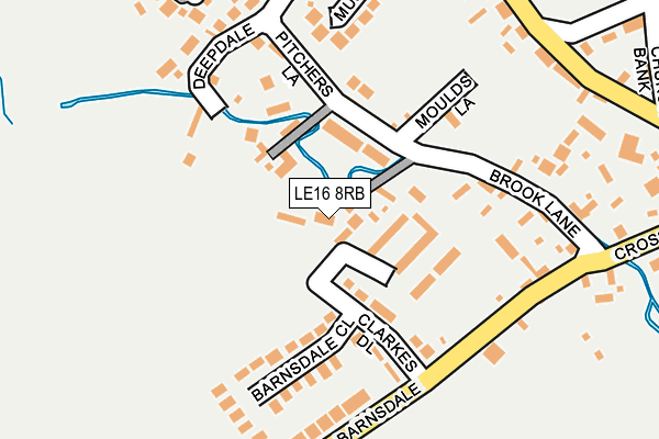
LE16 8RB lies on Brookdale in Great Easton, Market Harborough. LE16 8RB is located in the Nevill electoral ward, within the local authority district of Harborough and the English Parliamentary constituency of Rutland and Melton. The Sub Integrated Care Board (ICB) Location is NHS Leicester, Leicestershire and Rutland ICB - 03W and the police force is Leicestershire. This postcode has been in use since August 2005.


GetTheData
Source: OS OpenMap – Local (Ordnance Survey)
Source: OS VectorMap District (Ordnance Survey)
Licence: Open Government Licence (requires attribution)
| Easting | 484613 |
| Northing | 292922 |
| Latitude | 52.527609 |
| Longitude | -0.754208 |
GetTheData
Source: Open Postcode Geo
Licence: Open Government Licence
| Street | Brookdale |
| Locality | Great Easton |
| Town/City | Market Harborough |
| Country | England |
| Postcode District | LE16 |
| ➜ LE16 open data dashboard ➜ See where LE16 is on a map ➜ Where is Great Easton? | |
GetTheData
Source: Land Registry Price Paid Data
Licence: Open Government Licence
Elevation or altitude of LE16 8RB as distance above sea level:
| Metres | Feet | |
|---|---|---|
| Elevation | 60m | 197ft |
Elevation is measured from the approximate centre of the postcode, to the nearest point on an OS contour line from OS Terrain 50, which has contour spacing of ten vertical metres.
➜ How high above sea level am I? Find the elevation of your current position using your device's GPS.
GetTheData
Source: Open Postcode Elevation
Licence: Open Government Licence
| Ward | Nevill |
| Constituency | Rutland And Melton |
GetTheData
Source: ONS Postcode Database
Licence: Open Government Licence
2017 1 JUN £660,000 |
2003 26 SEP £125,000 |
THE OLD BYRE, BROOKDALE, GREAT EASTON, MARKET HARBOROUGH, LE16 8RB 2003 26 SEP £127,505 |
GetTheData
Source: HM Land Registry Price Paid Data
Licence: Contains HM Land Registry data © Crown copyright and database right 2024. This data is licensed under the Open Government Licence v3.0.
| May 2022 | Public order | On or near Banbury Lane | 352m |
| April 2022 | Drugs | On or near Banbury Lane | 352m |
| March 2022 | Other theft | On or near Cross Bank | 324m |
| ➜ Get more crime data in our Crime section | |||
GetTheData
Source: data.police.uk
Licence: Open Government Licence
| Broadgate (High Street) | Great Easton | 310m |
| Church Bank (High Street) | Great Easton | 340m |
| Bringhurst Turn (Great Easton Road) | Bringhurst | 540m |
| Bringhurst Turn (Great Easton Road) | Bringhurst | 546m |
| Telephone Box (Great Easton Road) | Bringhurst | 822m |
| Corby Station | 6.2km |
GetTheData
Source: NaPTAN
Licence: Open Government Licence
GetTheData
Source: ONS Postcode Database
Licence: Open Government Licence


➜ Get more ratings from the Food Standards Agency
GetTheData
Source: Food Standards Agency
Licence: FSA terms & conditions
| Last Collection | |||
|---|---|---|---|
| Location | Mon-Fri | Sat | Distance |
| Cottingham Rso | 16:45 | 10:00 | 2,751m |
| Shire Road | 17:00 | 11:15 | 3,693m |
| Tanfield Grove | 17:00 | 11:15 | 4,815m |
GetTheData
Source: Dracos
Licence: Creative Commons Attribution-ShareAlike
| Facility | Distance |
|---|---|
| Cottingham C Of E Primary School Berryfield Road, Cottingham, Market Harborough Grass Pitches, Artificial Grass Pitch | 2.7km |
| Old Eastonians Cricket Club Rockingham Castle, Rockingham, Market Harborough Grass Pitches | 2.8km |
| Corby Rfc Rockingham Road, Corby Grass Pitches, Artificial Grass Pitch | 3.3km |
GetTheData
Source: Active Places
Licence: Open Government Licence
| School | Phase of Education | Distance |
|---|---|---|
| Bringhurst Primary School Great Easton Road, Bringhurst, Market Harborough, LE16 8RH | Primary | 413m |
| Cottingham Church of England Primary School Berryfield Road, (Near Corby), Market Harborough, LE16 8XB | Primary | 2.7km |
| Lodge Park Academy Shetland Way, Corby, NN17 2JH | Secondary | 3.6km |
GetTheData
Source: Edubase
Licence: Open Government Licence
The below table lists the International Territorial Level (ITL) codes (formerly Nomenclature of Territorial Units for Statistics (NUTS) codes) and Local Administrative Units (LAU) codes for LE16 8RB:
| ITL 1 Code | Name |
|---|---|
| TLF | East Midlands (England) |
| ITL 2 Code | Name |
| TLF2 | Leicestershire, Rutland and Northamptonshire |
| ITL 3 Code | Name |
| TLF22 | Leicestershire CC and Rutland |
| LAU 1 Code | Name |
| E07000131 | Harborough |
GetTheData
Source: ONS Postcode Directory
Licence: Open Government Licence
The below table lists the Census Output Area (OA), Lower Layer Super Output Area (LSOA), and Middle Layer Super Output Area (MSOA) for LE16 8RB:
| Code | Name | |
|---|---|---|
| OA | E00130953 | |
| LSOA | E01025809 | Harborough 002B |
| MSOA | E02005368 | Harborough 002 |
GetTheData
Source: ONS Postcode Directory
Licence: Open Government Licence
| LE16 8SU | Little London | 75m |
| LE16 8RF | Home Close | 79m |
| LE16 8SJ | Brook Lane | 123m |
| LE16 8SP | Clarkesdale | 124m |
| LE16 8TA | Pitchers Lane | 142m |
| LE16 8SZ | Moulds Lane | 143m |
| LE16 8SQ | Barnsdale Close | 167m |
| LE16 8SS | Deepdale | 172m |
| LE16 8SG | Barnsdale | 177m |
| LE16 8TJ | Musk Close | 209m |
GetTheData
Source: Open Postcode Geo; Land Registry Price Paid Data
Licence: Open Government Licence