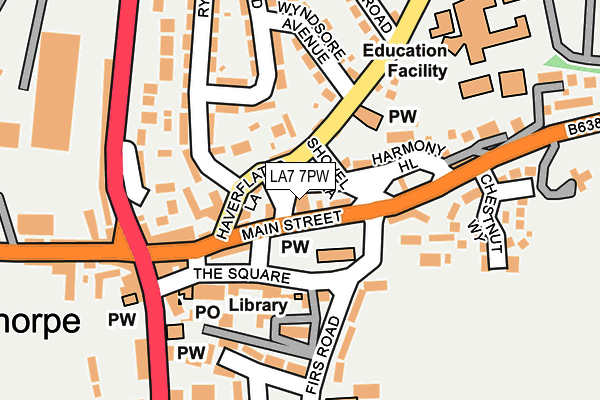
LA7 7PW is located in the Kent Estuary electoral ward, within the unitary authority of Westmorland and Furness and the English Parliamentary constituency of Westmorland and Lonsdale. The Sub Integrated Care Board (ICB) Location is NHS Lancashire and South Cumbria ICB - 01K and the police force is Cumbria. This postcode has been in use since January 1980.


GetTheData
Source: OS OpenMap – Local (Ordnance Survey)
Source: OS VectorMap District (Ordnance Survey)
Licence: Open Government Licence (requires attribution)
| Easting | 349853 |
| Northing | 481559 |
| Latitude | 54.227277 |
| Longitude | -2.770704 |
GetTheData
Source: Open Postcode Geo
Licence: Open Government Licence
| Country | England |
| Postcode District | LA7 |
| ➜ LA7 open data dashboard ➜ See where LA7 is on a map ➜ Where is Milnthorpe? | |
GetTheData
Source: Land Registry Price Paid Data
Licence: Open Government Licence
Elevation or altitude of LA7 7PW as distance above sea level:
| Metres | Feet | |
|---|---|---|
| Elevation | 20m | 66ft |
Elevation is measured from the approximate centre of the postcode, to the nearest point on an OS contour line from OS Terrain 50, which has contour spacing of ten vertical metres.
➜ How high above sea level am I? Find the elevation of your current position using your device's GPS.
GetTheData
Source: Open Postcode Elevation
Licence: Open Government Licence
| Ward | Kent Estuary |
| Constituency | Westmorland And Lonsdale |
GetTheData
Source: ONS Postcode Database
Licence: Open Government Licence
| January 2024 | Vehicle crime | On or near Parking Area | 284m |
| December 2023 | Vehicle crime | On or near Parking Area | 284m |
| June 2022 | Drugs | On or near Parking Area | 91m |
| ➜ Get more crime data in our Crime section | |||
GetTheData
Source: data.police.uk
Licence: Open Government Licence
| The Square (Main Street) | Milnthorpe | 26m |
| The Square | Milnthorpe | 58m |
| Chestnut Park (B6384) | Milnthorpe | 163m |
| Chestnut Park (B6384) | Milnthorpe | 166m |
| Beetham Road | Milnthorpe | 187m |
| Arnside Station | 4.6km |
GetTheData
Source: NaPTAN
Licence: Open Government Licence
GetTheData
Source: ONS Postcode Database
Licence: Open Government Licence


➜ Get more ratings from the Food Standards Agency
GetTheData
Source: Food Standards Agency
Licence: FSA terms & conditions
| Last Collection | |||
|---|---|---|---|
| Location | Mon-Fri | Sat | Distance |
| Haverflatts | 16:00 | 11:00 | 116m |
| Milnthorpe Post Office | 17:15 | 12:00 | 209m |
| Firs Road | 16:00 | 11:00 | 236m |
GetTheData
Source: Dracos
Licence: Creative Commons Attribution-ShareAlike
| Facility | Distance |
|---|---|
| Dallam School (Milnthorpe) Milnthorpe Artificial Grass Pitch, Health and Fitness Gym, Sports Hall, Studio, Grass Pitches | 214m |
| Park Road Recreation Ground Park Road, Milnthorpe Grass Pitches, Sports Hall | 303m |
| Dallam School (Heversham) Heversham, Milnthorpe Sports Hall, Swimming Pool, Health and Fitness Gym, Outdoor Tennis Courts | 1.6km |
GetTheData
Source: Active Places
Licence: Open Government Licence
| School | Phase of Education | Distance |
|---|---|---|
| Dallam School Haverflatts Lane, Milnthorpe, Cumbria, LA7 7DD | Secondary | 214m |
| Milnthorpe Primary School Firs Road, Milnthorpe, LA7 7QF | Primary | 218m |
| Wings School Whassett, Milnthorpe, Cumbria, Milnthorpe, LA7 7DN | Not applicable | 2km |
GetTheData
Source: Edubase
Licence: Open Government Licence
The below table lists the International Territorial Level (ITL) codes (formerly Nomenclature of Territorial Units for Statistics (NUTS) codes) and Local Administrative Units (LAU) codes for LA7 7PW:
| ITL 1 Code | Name |
|---|---|
| TLD | North West (England) |
| ITL 2 Code | Name |
| TLD1 | Cumbria |
| ITL 3 Code | Name |
| TLD12 | East Cumbria |
| LAU 1 Code | Name |
| E07000031 | South Lakeland |
GetTheData
Source: ONS Postcode Directory
Licence: Open Government Licence
The below table lists the Census Output Area (OA), Lower Layer Super Output Area (LSOA), and Middle Layer Super Output Area (MSOA) for LA7 7PW:
| Code | Name | |
|---|---|---|
| OA | E00097994 | |
| LSOA | E01019382 | South Lakeland 011E |
| MSOA | E02004025 | South Lakeland 011 |
GetTheData
Source: ONS Postcode Directory
Licence: Open Government Licence
| LA7 7PZ | Windy Hill | 32m |
| LA7 7PY | Police Square | 34m |
| LA7 7PP | Main Street | 34m |
| LA7 7PS | Haverflatts Lane | 49m |
| LA7 7PN | Main Street | 87m |
| LA7 7QJ | The Square | 115m |
| LA7 7QA | Harmony Hill | 121m |
| LA7 7QE | 121m | |
| LA7 7QY | Printers Mews | 126m |
| LA7 7QH | Rigney Bank | 130m |
GetTheData
Source: Open Postcode Geo; Land Registry Price Paid Data
Licence: Open Government Licence