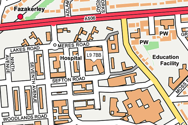
L9 7BB is located in the Fazakerley West electoral ward, within the metropolitan district of Liverpool and the English Parliamentary constituency of Liverpool, Walton. The Sub Integrated Care Board (ICB) Location is NHS Cheshire and Merseyside ICB - 99A and the police force is Merseyside. This postcode has been in use since January 2015.


GetTheData
Source: OS OpenMap – Local (Ordnance Survey)
Source: OS VectorMap District (Ordnance Survey)
Licence: Open Government Licence (requires attribution)
| Easting | 338141 |
| Northing | 397180 |
| Latitude | 53.467708 |
| Longitude | -2.933303 |
GetTheData
Source: Open Postcode Geo
Licence: Open Government Licence
| Country | England |
| Postcode District | L9 |
| ➜ L9 open data dashboard ➜ See where L9 is on a map ➜ Where is Liverpool? | |
GetTheData
Source: Land Registry Price Paid Data
Licence: Open Government Licence
Elevation or altitude of L9 7BB as distance above sea level:
| Metres | Feet | |
|---|---|---|
| Elevation | 20m | 66ft |
Elevation is measured from the approximate centre of the postcode, to the nearest point on an OS contour line from OS Terrain 50, which has contour spacing of ten vertical metres.
➜ How high above sea level am I? Find the elevation of your current position using your device's GPS.
GetTheData
Source: Open Postcode Elevation
Licence: Open Government Licence
| Ward | Fazakerley West |
| Constituency | Liverpool, Walton |
GetTheData
Source: ONS Postcode Database
Licence: Open Government Licence
| January 2024 | Burglary | On or near Garden Lane | 402m |
| January 2024 | Burglary | On or near Garden Lane | 402m |
| July 2023 | Criminal damage and arson | On or near Garden Lane | 402m |
| ➜ Get more crime data in our Crime section | |||
GetTheData
Source: data.police.uk
Licence: Open Government Licence
| Sefton Road (Aintree Hospital) | Fazakerley | 91m |
| Sefton Road (Aintree Hospital) | Fazakerley | 123m |
| Longmoor Lane (Lower Lane) | Fazakerley | 126m |
| Fazakerley Methodist Church (Lower Lane) | Fazakerley | 133m |
| Fazakerley Station (Longmoor Lane) | Fazakerley | 193m |
| Fazakerley Station | 0.3km |
| Aintree Station | 1.7km |
| Orrell Park Station | 2.1km |
GetTheData
Source: NaPTAN
Licence: Open Government Licence
GetTheData
Source: ONS Postcode Database
Licence: Open Government Licence


➜ Get more ratings from the Food Standards Agency
GetTheData
Source: Food Standards Agency
Licence: FSA terms & conditions
| Last Collection | |||
|---|---|---|---|
| Location | Mon-Fri | Sat | Distance |
| Signal Works Road | 16:00 | 12:00 | 454m |
| Longmoor Lane Post Office | 17:00 | 12:00 | 685m |
| Karonga Road | 16:00 | 12:00 | 944m |
GetTheData
Source: Dracos
Licence: Creative Commons Attribution-ShareAlike
| Facility | Distance |
|---|---|
| Body Talk North West Ltd (Closed) Longmoor Lane, Liverpool Health and Fitness Gym, Studio | 242m |
| Holy Name Rc Primary School Moss Pits Lane, Fazakerley, Liverpool Grass Pitches | 285m |
| Adlam Park Activity Centre Adlam Road, Liverpool Ten, Liverpool Grass Pitches, Artificial Grass Pitch | 482m |
GetTheData
Source: Active Places
Licence: Open Government Licence
| School | Phase of Education | Distance |
|---|---|---|
| Holy Name Catholic Primary School Moss Pits Lane, Fazakerley, Liverpool, L10 9LG | Primary | 285m |
| Barlows Primary School Barlows Lane, Fazakerley, Barlows Primary School, Fazakerley Liverpool, L9 9EH | Primary | 530m |
| Dixons Fazakerley Academy Sherwoods Lane, Fazakerley, Liverpool, L10 1LB | Secondary | 602m |
GetTheData
Source: Edubase
Licence: Open Government Licence
The below table lists the International Territorial Level (ITL) codes (formerly Nomenclature of Territorial Units for Statistics (NUTS) codes) and Local Administrative Units (LAU) codes for L9 7BB:
| ITL 1 Code | Name |
|---|---|
| TLD | North West (England) |
| ITL 2 Code | Name |
| TLD7 | Merseyside |
| ITL 3 Code | Name |
| TLD72 | Liverpool |
| LAU 1 Code | Name |
| E08000012 | Liverpool |
GetTheData
Source: ONS Postcode Directory
Licence: Open Government Licence
The below table lists the Census Output Area (OA), Lower Layer Super Output Area (LSOA), and Middle Layer Super Output Area (MSOA) for L9 7BB:
| Code | Name | |
|---|---|---|
| OA | E00033725 | |
| LSOA | E01006655 | Liverpool 001C |
| MSOA | E02001347 | Liverpool 001 |
GetTheData
Source: ONS Postcode Directory
Licence: Open Government Licence
| L9 7AD | Lower Lane | 147m |
| L9 9EW | Longmoor Lane | 181m |
| L9 9ES | Adlam Road | 207m |
| L10 9LB | Longmoor Close | 226m |
| L9 9EX | Signal Works Road | 265m |
| L9 9ET | Adlam Crescent | 266m |
| L10 1LA | Longmoor Lane | 292m |
| L10 1LJ | Rycroft Road | 299m |
| L10 9LA | Longmoor Lane | 308m |
| L10 1LQ | Adlam Road | 318m |
GetTheData
Source: Open Postcode Geo; Land Registry Price Paid Data
Licence: Open Government Licence