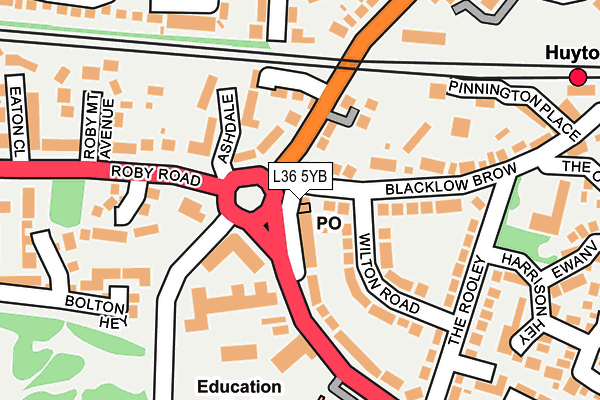
L36 5YB lies on Tarbock Road in Huyton, Liverpool. L36 5YB is located in the Roby electoral ward, within the metropolitan district of Knowsley and the English Parliamentary constituency of Knowsley. The Sub Integrated Care Board (ICB) Location is NHS Cheshire and Merseyside ICB - 01J and the police force is Merseyside. This postcode has been in use since January 1980.


GetTheData
Source: OS OpenMap – Local (Ordnance Survey)
Source: OS VectorMap District (Ordnance Survey)
Licence: Open Government Licence (requires attribution)
| Easting | 343790 |
| Northing | 390513 |
| Latitude | 53.408422 |
| Longitude | -2.847026 |
GetTheData
Source: Open Postcode Geo
Licence: Open Government Licence
| Street | Tarbock Road |
| Locality | Huyton |
| Town/City | Liverpool |
| Country | England |
| Postcode District | L36 |
| ➜ L36 open data dashboard ➜ See where L36 is on a map ➜ Where is Huyton with Roby? | |
GetTheData
Source: Land Registry Price Paid Data
Licence: Open Government Licence
Elevation or altitude of L36 5YB as distance above sea level:
| Metres | Feet | |
|---|---|---|
| Elevation | 30m | 98ft |
Elevation is measured from the approximate centre of the postcode, to the nearest point on an OS contour line from OS Terrain 50, which has contour spacing of ten vertical metres.
➜ How high above sea level am I? Find the elevation of your current position using your device's GPS.
GetTheData
Source: Open Postcode Elevation
Licence: Open Government Licence
| Ward | Roby |
| Constituency | Knowsley |
GetTheData
Source: ONS Postcode Database
Licence: Open Government Licence
| September 2023 | Other crime | On or near St Catherines Close | 436m |
| September 2023 | Violence and sexual offences | On or near St Catherines Close | 436m |
| June 2023 | Anti-social behaviour | On or near Ruskin Way | 360m |
| ➜ Get more crime data in our Crime section | |||
GetTheData
Source: data.police.uk
Licence: Open Government Licence
| Blacklow Brow (Tarbock Road) | Blacklow Brow | 42m |
| Sandfield (Archway Road) | Blacklow Brow | 62m |
| Waterside Park (Roby Road) | Roby | 192m |
| The Rooley (Tarbock Road) | Blacklow Brow | 206m |
| The Rooley (Tarbock Road) | Huyton Park | 293m |
| Huyton Station | 0.3km |
| Roby Station | 0.6km |
| Broad Green Station | 3.1km |
GetTheData
Source: NaPTAN
Licence: Open Government Licence
GetTheData
Source: ONS Postcode Database
Licence: Open Government Licence


➜ Get more ratings from the Food Standards Agency
GetTheData
Source: Food Standards Agency
Licence: FSA terms & conditions
| Last Collection | |||
|---|---|---|---|
| Location | Mon-Fri | Sat | Distance |
| Huyton Post Office | 17:45 | 12:00 | 582m |
| Glade Road | 17:00 | 12:00 | 1,341m |
| The Boundary | 17:30 | 12:00 | 1,556m |
GetTheData
Source: Dracos
Licence: Creative Commons Attribution-ShareAlike
| Facility | Distance |
|---|---|
| St Annes Catholic Primary School Marina Crescent, Huyton, Liverpool Grass Pitches | 303m |
| Twickenham Drive Playing Field Twickenham Drive, Liverpool Grass Pitches | 308m |
| Huyton Leisure Centre (Closed) Roby Road, Huyton, Liverpool Sports Hall, Swimming Pool, Health and Fitness Gym, Studio, Squash Courts | 314m |
GetTheData
Source: Active Places
Licence: Open Government Licence
| School | Phase of Education | Distance |
|---|---|---|
| Blacklow Brow School Blacklow Brow School, Tarbock Road, Huyton, Liverpool, L36 5XW | Primary | 219m |
| St Anne's Catholic Primary School Marina Crescent, Huyton, Liverpool, L36 5XL | Primary | 303m |
| Huyton With Roby Church of England Primary School Rupert Road, Huyton, Liverpool, L36 9TF | Primary | 553m |
GetTheData
Source: Edubase
Licence: Open Government Licence
The below table lists the International Territorial Level (ITL) codes (formerly Nomenclature of Territorial Units for Statistics (NUTS) codes) and Local Administrative Units (LAU) codes for L36 5YB:
| ITL 1 Code | Name |
|---|---|
| TLD | North West (England) |
| ITL 2 Code | Name |
| TLD7 | Merseyside |
| ITL 3 Code | Name |
| TLD71 | East Merseyside |
| LAU 1 Code | Name |
| E08000011 | Knowsley |
GetTheData
Source: ONS Postcode Directory
Licence: Open Government Licence
The below table lists the Census Output Area (OA), Lower Layer Super Output Area (LSOA), and Middle Layer Super Output Area (MSOA) for L36 5YB:
| Code | Name | |
|---|---|---|
| OA | E00032801 | |
| LSOA | E01006475 | Knowsley 016D |
| MSOA | E02001342 | Knowsley 016 |
GetTheData
Source: ONS Postcode Directory
Licence: Open Government Licence
| L36 4NA | Twickenham Drive | 85m |
| L36 5XN | Tarbock Road | 93m |
| L36 5XF | Blacklow Brow | 99m |
| L36 4QS | Ashdale | 104m |
| L36 9XA | Archway Road | 107m |
| L36 9XR | Sandfield | 110m |
| L36 5XB | Wilton Road | 118m |
| L36 5XE | Blacklow Brow | 155m |
| L36 5XW | Tarbock Road | 160m |
| L36 5XH | The Rooley | 178m |
GetTheData
Source: Open Postcode Geo; Land Registry Price Paid Data
Licence: Open Government Licence