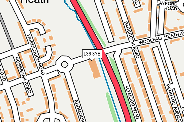
L36 3YE is located in the Page Moss electoral ward, within the metropolitan district of Knowsley and the English Parliamentary constituency of Knowsley. The Sub Integrated Care Board (ICB) Location is NHS Cheshire and Merseyside ICB - 01J and the police force is Merseyside. This postcode has been in use since December 2000.


GetTheData
Source: OS OpenMap – Local (Ordnance Survey)
Source: OS VectorMap District (Ordnance Survey)
Licence: Open Government Licence (requires attribution)
| Easting | 343573 |
| Northing | 392256 |
| Latitude | 53.424064 |
| Longitude | -2.850602 |
GetTheData
Source: Open Postcode Geo
Licence: Open Government Licence
| Country | England |
| Postcode District | L36 |
| ➜ L36 open data dashboard ➜ See where L36 is on a map ➜ Where is Huyton with Roby? | |
GetTheData
Source: Land Registry Price Paid Data
Licence: Open Government Licence
Elevation or altitude of L36 3YE as distance above sea level:
| Metres | Feet | |
|---|---|---|
| Elevation | 30m | 98ft |
Elevation is measured from the approximate centre of the postcode, to the nearest point on an OS contour line from OS Terrain 50, which has contour spacing of ten vertical metres.
➜ How high above sea level am I? Find the elevation of your current position using your device's GPS.
GetTheData
Source: Open Postcode Elevation
Licence: Open Government Licence
| Ward | Page Moss |
| Constituency | Knowsley |
GetTheData
Source: ONS Postcode Database
Licence: Open Government Licence
| January 2024 | Violence and sexual offences | On or near Belton Road | 305m |
| October 2023 | Other theft | On or near Calgary Way | 445m |
| September 2023 | Anti-social behaviour | On or near Calgary Way | 445m |
| ➜ Get more crime data in our Crime section | |||
GetTheData
Source: data.police.uk
Licence: Open Government Licence
| Parbrook Road (Woolfall Heath Avenue) | Longview | 157m |
| Fairclough Road (Woolfall Heath Avenue) | Woolfall Heath | 208m |
| Pennard Avenue (Woolfall Heath Avenue) | Longview | 222m |
| Mardale Road (Woolfall Heath Avenue) | Woolfall Heath | 251m |
| Kingsway (Liverpool Road) | Woolfall Heath | 418m |
| Roby Station | 1.6km |
| Huyton Station | 1.7km |
| Prescot Station | 3.4km |
GetTheData
Source: NaPTAN
Licence: Open Government Licence
GetTheData
Source: ONS Postcode Database
Licence: Open Government Licence


➜ Get more ratings from the Food Standards Agency
GetTheData
Source: Food Standards Agency
Licence: FSA terms & conditions
| Last Collection | |||
|---|---|---|---|
| Location | Mon-Fri | Sat | Distance |
| Glade Road | 17:00 | 12:00 | 693m |
| Pilch Lane East | 17:15 | 12:00 | 1,074m |
| Lordens Road | 16:00 | 12:00 | 1,170m |
GetTheData
Source: Dracos
Licence: Creative Commons Attribution-ShareAlike
| Facility | Distance |
|---|---|
| Alt Park Endmoor Road, Huyton Grass Pitches | 157m |
| Lord Derby Memorial Playing Fields Knowsley Lane, Liverpool Grass Pitches | 705m |
| St Columbas School Hillside Road, Huyton, Liverpool Sports Hall | 717m |
GetTheData
Source: Active Places
Licence: Open Government Licence
| School | Phase of Education | Distance |
|---|---|---|
| Park View Academy Park View, Huyton, Liverpool, L36 2LL | Primary | 637m |
| St Aloysius Catholic Primary School Twig Lane, Huyton-with-Roby, Liverpool, L36 2LF | Primary | 704m |
| St Columba's Catholic Primary School Hillside Road, Huyton, Knowsley, Liverpool, L36 8BL | Primary | 717m |
GetTheData
Source: Edubase
Licence: Open Government Licence
The below table lists the International Territorial Level (ITL) codes (formerly Nomenclature of Territorial Units for Statistics (NUTS) codes) and Local Administrative Units (LAU) codes for L36 3YE:
| ITL 1 Code | Name |
|---|---|
| TLD | North West (England) |
| ITL 2 Code | Name |
| TLD7 | Merseyside |
| ITL 3 Code | Name |
| TLD71 | East Merseyside |
| LAU 1 Code | Name |
| E08000011 | Knowsley |
GetTheData
Source: ONS Postcode Directory
Licence: Open Government Licence
The below table lists the Census Output Area (OA), Lower Layer Super Output Area (LSOA), and Middle Layer Super Output Area (MSOA) for L36 3YE:
| Code | Name | |
|---|---|---|
| OA | E00032779 | |
| LSOA | E01006470 | Knowsley 008E |
| MSOA | E02001334 | Knowsley 008 |
GetTheData
Source: ONS Postcode Directory
Licence: Open Government Licence
| L36 3TP | Woolfall Heath Avenue | 128m |
| L36 3TJ | Woolfall Heath Avenue | 166m |
| L36 3XB | Parbrook Road | 187m |
| L36 3UZ | Altmoor Road | 195m |
| L36 3UH | Endmoor Road | 196m |
| L36 3UY | Altmoor Road | 207m |
| L36 3XF | Parbrook Road | 216m |
| L36 3XA | Parbrook Road | 216m |
| L36 3SQ | Pennard Avenue | 217m |
| L36 3US | Fairclough Road | 223m |
GetTheData
Source: Open Postcode Geo; Land Registry Price Paid Data
Licence: Open Government Licence