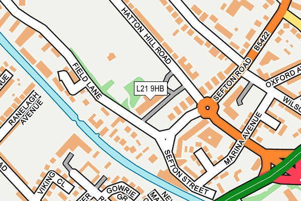
L21 9HB is located in the Ford electoral ward, within the metropolitan district of Sefton and the English Parliamentary constituency of Bootle. The Sub Integrated Care Board (ICB) Location is NHS Cheshire and Merseyside ICB - 01T and the police force is Merseyside. This postcode has been in use since May 1994.


GetTheData
Source: OS OpenMap – Local (Ordnance Survey)
Source: OS VectorMap District (Ordnance Survey)
Licence: Open Government Licence (requires attribution)
| Easting | 333582 |
| Northing | 397610 |
| Latitude | 53.471016 |
| Longitude | -3.002059 |
GetTheData
Source: Open Postcode Geo
Licence: Open Government Licence
| Country | England |
| Postcode District | L21 |
| ➜ L21 open data dashboard ➜ See where L21 is on a map ➜ Where is Litherland? | |
GetTheData
Source: Land Registry Price Paid Data
Licence: Open Government Licence
Elevation or altitude of L21 9HB as distance above sea level:
| Metres | Feet | |
|---|---|---|
| Elevation | 20m | 66ft |
Elevation is measured from the approximate centre of the postcode, to the nearest point on an OS contour line from OS Terrain 50, which has contour spacing of ten vertical metres.
➜ How high above sea level am I? Find the elevation of your current position using your device's GPS.
GetTheData
Source: Open Postcode Elevation
Licence: Open Government Licence
| Ward | Ford |
| Constituency | Bootle |
GetTheData
Source: ONS Postcode Database
Licence: Open Government Licence
| June 2022 | Drugs | On or near Sefton Road | 77m |
| June 2022 | Drugs | On or near Sefton Road | 77m |
| June 2022 | Criminal damage and arson | On or near Sefton Road | 77m |
| ➜ Get more crime data in our Crime section | |||
GetTheData
Source: data.police.uk
Licence: Open Government Licence
| Sefton Road (Hatton Hill Road) | Hatton Hill Park | 70m |
| Sefton Road (Hatton Hill Road) | Hatton Hill Park | 86m |
| Moss Bank Park (Field Lane) | Hatton Hill Park | 124m |
| Moss Bank Park (Field Lane) | Hatton Hill Park | 149m |
| Marina Avenue (Hawthorne Road) | Litherland | 186m |
| Seaforth & Litherland Station | 0.6km |
| Waterloo (Merseyside) Station | 1.6km |
| Bootle New Strand Station | 2km |
GetTheData
Source: NaPTAN
Licence: Open Government Licence
GetTheData
Source: ONS Postcode Database
Licence: Open Government Licence


➜ Get more ratings from the Food Standards Agency
GetTheData
Source: Food Standards Agency
Licence: FSA terms & conditions
| Last Collection | |||
|---|---|---|---|
| Location | Mon-Fri | Sat | Distance |
| Ruthven Road | 17:00 | 12:00 | 202m |
| Ascot Avenue | 17:00 | 12:00 | 394m |
| Mereton Village | 17:00 | 12:00 | 655m |
GetTheData
Source: Dracos
Licence: Creative Commons Attribution-ShareAlike
| Facility | Distance |
|---|---|
| St Wilfrid's Catholic High School (Closed) Orrell Road, Litherland , Liverpool Sports Hall, Grass Pitches | 586m |
| St Philips Ce Primary School Church Road, Litherland, Liverpool Grass Pitches | 593m |
| Brookvale Playing Fields Brook Vale, Waterloo Grass Pitches | 877m |
GetTheData
Source: Active Places
Licence: Open Government Licence
| School | Phase of Education | Distance |
|---|---|---|
| English Martyrs' Catholic Primary School School Lane, Litherland, Liverpool, L21 7LX | Primary | 418m |
| St Philip's Church of England Controlled Primary School Church Road, Litherland, Liverpool, L21 8NZ | Primary | 593m |
| Rimrose Hope CofE Primary School Sandy Road, Seaforth, Liverpool, L21 1AD | Primary | 698m |
GetTheData
Source: Edubase
Licence: Open Government Licence
The below table lists the International Territorial Level (ITL) codes (formerly Nomenclature of Territorial Units for Statistics (NUTS) codes) and Local Administrative Units (LAU) codes for L21 9HB:
| ITL 1 Code | Name |
|---|---|
| TLD | North West (England) |
| ITL 2 Code | Name |
| TLD7 | Merseyside |
| ITL 3 Code | Name |
| TLD73 | Sefton |
| LAU 1 Code | Name |
| E08000014 | Sefton |
GetTheData
Source: ONS Postcode Directory
Licence: Open Government Licence
The below table lists the Census Output Area (OA), Lower Layer Super Output Area (LSOA), and Middle Layer Super Output Area (MSOA) for L21 9HB:
| Code | Name | |
|---|---|---|
| OA | E00035379 | |
| LSOA | E01006977 | Sefton 032E |
| MSOA | E02001460 | Sefton 032 |
GetTheData
Source: ONS Postcode Directory
Licence: Open Government Licence
| L21 7PG | Sefton Road | 102m |
| L21 9HA | Sefton Road | 119m |
| L21 7PD | Sefton Street | 128m |
| L21 7PE | Marina Avenue | 148m |
| L21 9PL | Moss Bank Park | 156m |
| L21 7PJ | Hawthorne Road | 184m |
| L21 2PE | Ruthven Road | 190m |
| L21 9JN | Hatton Hill Road | 196m |
| L21 7PF | Marina Avenue | 218m |
| L21 9HP | Litherland Park | 220m |
GetTheData
Source: Open Postcode Geo; Land Registry Price Paid Data
Licence: Open Government Licence