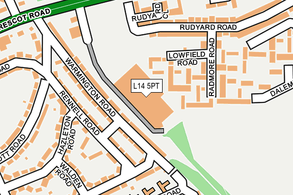
L14 5PT is located in the Sandfield Park electoral ward, within the metropolitan district of Liverpool and the English Parliamentary constituency of Liverpool, West Derby. The Sub Integrated Care Board (ICB) Location is NHS Cheshire and Merseyside ICB - 99A and the police force is Merseyside. This postcode has been in use since January 1993.


GetTheData
Source: OS OpenMap – Local (Ordnance Survey)
Source: OS VectorMap District (Ordnance Survey)
Licence: Open Government Licence (requires attribution)
| Easting | 340414 |
| Northing | 391289 |
| Latitude | 53.415026 |
| Longitude | -2.897951 |
GetTheData
Source: Open Postcode Geo
Licence: Open Government Licence
| Country | England |
| Postcode District | L14 |
| ➜ L14 open data dashboard ➜ See where L14 is on a map ➜ Where is Liverpool? | |
GetTheData
Source: Land Registry Price Paid Data
Licence: Open Government Licence
Elevation or altitude of L14 5PT as distance above sea level:
| Metres | Feet | |
|---|---|---|
| Elevation | 40m | 131ft |
Elevation is measured from the approximate centre of the postcode, to the nearest point on an OS contour line from OS Terrain 50, which has contour spacing of ten vertical metres.
➜ How high above sea level am I? Find the elevation of your current position using your device's GPS.
GetTheData
Source: Open Postcode Elevation
Licence: Open Government Licence
| Ward | Sandfield Park |
| Constituency | Liverpool, West Derby |
GetTheData
Source: ONS Postcode Database
Licence: Open Government Licence
| January 2024 | Public order | On or near Dalemeadow Road | 298m |
| January 2024 | Violence and sexual offences | On or near Dalemeadow Road | 298m |
| January 2024 | Criminal damage and arson | On or near Walsh Road | 376m |
| ➜ Get more crime data in our Crime section | |||
GetTheData
Source: data.police.uk
Licence: Open Government Licence
| Rudyard Road (East Prescot Road) | Little Bongs | 208m |
| Chatterton Road (East Prescot Road) | West Derby | 295m |
| Walsh Road (Broadgreen Hospital) | Broadgreen | 343m |
| Eaton Road (East Prescot Road) | Little Bongs | 359m |
| Thomas Lane (East Prescot Road) | Little Bongs | 392m |
| Broad Green Station | 1km |
| Wavertree Technology Park Station | 2km |
| Roby Station | 2.8km |
GetTheData
Source: NaPTAN
Licence: Open Government Licence
GetTheData
Source: ONS Postcode Database
Licence: Open Government Licence


➜ Get more ratings from the Food Standards Agency
GetTheData
Source: Food Standards Agency
Licence: FSA terms & conditions
| Last Collection | |||
|---|---|---|---|
| Location | Mon-Fri | Sat | Distance |
| Broadgreen Road | 16:15 | 12:00 | 874m |
| Eaton Road North | 16:15 | 12:00 | 1,053m |
| Derby Lane | 17:30 | 12:00 | 1,197m |
GetTheData
Source: Dracos
Licence: Creative Commons Attribution-ShareAlike
| Facility | Distance |
|---|---|
| Springfield Park Playing Fields (Closed) East Prescot Road, Liverpool Grass Pitches | 299m |
| Thomas Lane Playing Fields Thomas Lane, Liverpool Grass Pitches | 336m |
| Knotty Ash Community Centre (Closed) East Prescot Road, Liverpool Sports Hall | 388m |
GetTheData
Source: Active Places
Licence: Open Government Licence
| School | Phase of Education | Distance |
|---|---|---|
| East Prescot Road Nursery School 86 East Prescot Road, Liverpool, L14 1PW | Nursery | 319m |
| Knotty Ash Primary School Thomas Lane, Liverpool, L14 5NX | Primary | 476m |
| Dixons Broadgreen Academy Queens Drive, Liverpool, L13 5UQ | Secondary | 539m |
GetTheData
Source: Edubase
Licence: Open Government Licence
The below table lists the International Territorial Level (ITL) codes (formerly Nomenclature of Territorial Units for Statistics (NUTS) codes) and Local Administrative Units (LAU) codes for L14 5PT:
| ITL 1 Code | Name |
|---|---|
| TLD | North West (England) |
| ITL 2 Code | Name |
| TLD7 | Merseyside |
| ITL 3 Code | Name |
| TLD72 | Liverpool |
| LAU 1 Code | Name |
| E08000012 | Liverpool |
GetTheData
Source: ONS Postcode Directory
Licence: Open Government Licence
The below table lists the Census Output Area (OA), Lower Layer Super Output Area (LSOA), and Middle Layer Super Output Area (MSOA) for L14 5PT:
| Code | Name | |
|---|---|---|
| OA | E00033266 | |
| LSOA | E01006567 | Liverpool 026A |
| MSOA | E02001372 | Liverpool 026 |
GetTheData
Source: ONS Postcode Directory
Licence: Open Government Licence
| L14 5PH | Lowfield Road | 70m |
| L14 1QH | Warmington Road | 96m |
| L14 1QJ | Warmington Road | 101m |
| L14 5PQ | Radmore Road | 104m |
| L14 1QG | Rennell Road | 118m |
| L14 1QQ | Rennell Road | 148m |
| L14 5NP | Radmore Road | 172m |
| L14 1PZ | Burnthwaite Road | 175m |
| L14 1QB | Burnthwaite Road | 183m |
| L14 5NL | St Annes Cottages | 189m |
GetTheData
Source: Open Postcode Geo; Land Registry Price Paid Data
Licence: Open Government Licence