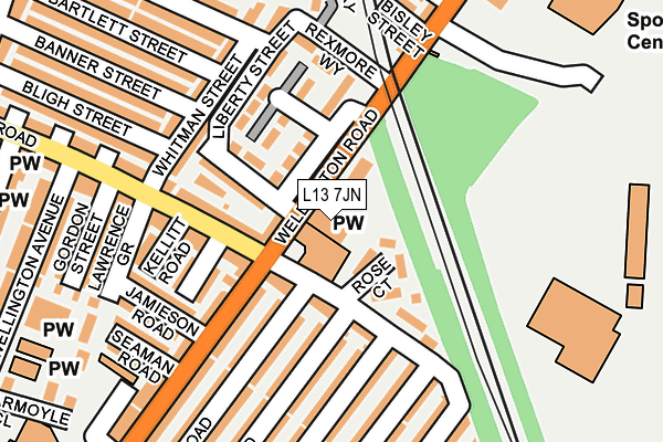
L13 7JN is located in the Stoneycroft electoral ward, within the metropolitan district of Liverpool and the English Parliamentary constituency of Liverpool, Wavertree. The Sub Integrated Care Board (ICB) Location is NHS Cheshire and Merseyside ICB - 99A and the police force is Merseyside. This postcode has been in use since December 2015.


GetTheData
Source: OS OpenMap – Local (Ordnance Survey)
Source: OS VectorMap District (Ordnance Survey)
Licence: Open Government Licence (requires attribution)
| Easting | 338608 |
| Northing | 391832 |
| Latitude | 53.419715 |
| Longitude | -2.925224 |
GetTheData
Source: Open Postcode Geo
Licence: Open Government Licence
| Country | England |
| Postcode District | L13 |
| ➜ L13 open data dashboard ➜ See where L13 is on a map ➜ Where is Liverpool? | |
GetTheData
Source: Land Registry Price Paid Data
Licence: Open Government Licence
Elevation or altitude of L13 7JN as distance above sea level:
| Metres | Feet | |
|---|---|---|
| Elevation | 40m | 131ft |
Elevation is measured from the approximate centre of the postcode, to the nearest point on an OS contour line from OS Terrain 50, which has contour spacing of ten vertical metres.
➜ How high above sea level am I? Find the elevation of your current position using your device's GPS.
GetTheData
Source: Open Postcode Elevation
Licence: Open Government Licence
| Ward | Stoneycroft |
| Constituency | Liverpool, Wavertree |
GetTheData
Source: ONS Postcode Database
Licence: Open Government Licence
| June 2022 | Other theft | On or near Tynwald Place | 153m |
| June 2022 | Violence and sexual offences | On or near Tynwald Place | 153m |
| June 2022 | Drugs | On or near Tynwald Place | 153m |
| ➜ Get more crime data in our Crime section | |||
GetTheData
Source: data.police.uk
Licence: Open Government Licence
| Woburn Hill (Green Lane) | Old Swan | 81m |
| Tynwald Hill (Green Lane) | Old Swan | 85m |
| Sark Road (Green Lane) | Stanley | 230m |
| Brelade Road (Green Lane) | Old Swan | 283m |
| Sutton Street (Green Lane) | Tuebrook | 290m |
| Wavertree Technology Park Station | 1.6km |
| Edge Hill Station | 2.4km |
| Broad Green Station | 2.6km |
GetTheData
Source: NaPTAN
Licence: Open Government Licence
GetTheData
Source: ONS Postcode Database
Licence: Open Government Licence


➜ Get more ratings from the Food Standards Agency
GetTheData
Source: Food Standards Agency
Licence: FSA terms & conditions
| Last Collection | |||
|---|---|---|---|
| Location | Mon-Fri | Sat | Distance |
| Old Swan Post Office | 17:00 | 12:00 | 694m |
| Derby Lane | 17:30 | 12:00 | 724m |
| Mill Bank | 17:15 | 12:00 | 787m |
GetTheData
Source: Dracos
Licence: Creative Commons Attribution-ShareAlike
| Facility | Distance |
|---|---|
| Arriva Green Lane Bus Depot Green Lane, Stoneycroft, Liverpool Health and Fitness Gym | 3m |
| Ernest Cookson School Bankfield Road, Liverpool Sports Hall, Grass Pitches | 558m |
| Derby Lane Health & Fitness Centre Derby Lane, Liverpool Health and Fitness Gym | 662m |
GetTheData
Source: Active Places
Licence: Open Government Licence
| School | Phase of Education | Distance |
|---|---|---|
| St Cecilia's Catholic Junior School Green Lane, Tuebrook, Liverpool, L13 7EA | Primary | 467m |
| St Cecilia's Catholic Infant & Nursery School Snaefell Avenue, Tuebrook, Liverpool, L13 7HB | Primary | 467m |
| Lister Junior School Green Lane, Liverpool, L13 7DT | Primary | 499m |
GetTheData
Source: Edubase
Licence: Open Government Licence
The below table lists the International Territorial Level (ITL) codes (formerly Nomenclature of Territorial Units for Statistics (NUTS) codes) and Local Administrative Units (LAU) codes for L13 7JN:
| ITL 1 Code | Name |
|---|---|
| TLD | North West (England) |
| ITL 2 Code | Name |
| TLD7 | Merseyside |
| ITL 3 Code | Name |
| TLD72 | Liverpool |
| LAU 1 Code | Name |
| E08000012 | Liverpool |
GetTheData
Source: ONS Postcode Directory
Licence: Open Government Licence
The below table lists the Census Output Area (OA), Lower Layer Super Output Area (LSOA), and Middle Layer Super Output Area (MSOA) for L13 7JN:
| Code | Name | |
|---|---|---|
| OA | E00034023 | |
| LSOA | E01006711 | Liverpool 027A |
| MSOA | E02001373 | Liverpool 027 |
GetTheData
Source: ONS Postcode Directory
Licence: Open Government Licence
| L13 7HS | Green Lane | 3m |
| L13 7BF | Keyhouse Gardens | 123m |
| L13 7BB | Green Lane | 131m |
| L13 7EF | Douglas Close | 155m |
| L13 6RJ | Woburn Green | 163m |
| L13 7DR | Tynwald Place | 169m |
| L13 7EB | Green Lane | 179m |
| L13 7DS | Tynwald Close | 210m |
| L13 7HN | Lister Drive | 216m |
| L13 6RQ | Green Lane | 218m |
GetTheData
Source: Open Postcode Geo; Land Registry Price Paid Data
Licence: Open Government Licence