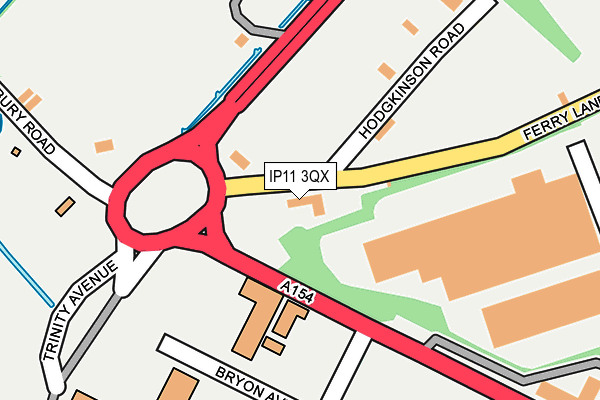
IP11 3QX is located in the Western Felixstowe electoral ward, within the local authority district of East Suffolk and the English Parliamentary constituency of Suffolk Coastal. The Sub Integrated Care Board (ICB) Location is NHS Suffolk and North East Essex ICB - 06L and the police force is Suffolk. This postcode has been in use since December 1999.


GetTheData
Source: OS OpenMap – Local (Ordnance Survey)
Source: OS VectorMap District (Ordnance Survey)
Licence: Open Government Licence (requires attribution)
| Easting | 627966 |
| Northing | 234244 |
| Latitude | 51.959915 |
| Longitude | 1.316648 |
GetTheData
Source: Open Postcode Geo
Licence: Open Government Licence
| Country | England |
| Postcode District | IP11 |
| ➜ IP11 open data dashboard ➜ See where IP11 is on a map ➜ Where is Felixstowe? | |
GetTheData
Source: Land Registry Price Paid Data
Licence: Open Government Licence
Elevation or altitude of IP11 3QX as distance above sea level:
| Metres | Feet | |
|---|---|---|
| Elevation | 10m | 33ft |
Elevation is measured from the approximate centre of the postcode, to the nearest point on an OS contour line from OS Terrain 50, which has contour spacing of ten vertical metres.
➜ How high above sea level am I? Find the elevation of your current position using your device's GPS.
GetTheData
Source: Open Postcode Elevation
Licence: Open Government Licence
| Ward | Western Felixstowe |
| Constituency | Suffolk Coastal |
GetTheData
Source: ONS Postcode Database
Licence: Open Government Licence
| June 2022 | Violence and sexual offences | On or near Parking Area | 403m |
| June 2022 | Anti-social behaviour | On or near Parking Area | 403m |
| May 2022 | Other theft | On or near Bryon Avenue | 201m |
| ➜ Get more crime data in our Crime section | |||
GetTheData
Source: data.police.uk
Licence: Open Government Licence
| Chelsworth Road (Wesel Avenue) | Grange Farm | 614m |
| Chelsworth Road (Wesel Avenue) | Grange Farm | 620m |
| Nayland Road (Wesel Avenue) | Grange Farm | 666m |
| Nayland Road (Wesel Avenue) | Grange Farm | 674m |
| Melford Way (Wesel Avenue) | Grange Farm | 712m |
| Trimley Station | 1.9km |
| Felixstowe Station | 2.5km |
| Harwich Town Station | 2.7km |
GetTheData
Source: NaPTAN
Licence: Open Government Licence
GetTheData
Source: ONS Postcode Database
Licence: Open Government Licence


➜ Get more ratings from the Food Standards Agency
GetTheData
Source: Food Standards Agency
Licence: FSA terms & conditions
| Last Collection | |||
|---|---|---|---|
| Location | Mon-Fri | Sat | Distance |
| Arwela Road | 17:30 | 12:00 | 1,772m |
| Langstons, Faulkeners Way | 17:00 | 07:00 | 2,254m |
| Bent Hill Post Office | 17:30 | 12:30 | 2,360m |
GetTheData
Source: Dracos
Licence: Creative Commons Attribution-ShareAlike
| Facility | Distance |
|---|---|
| Anytime Fitness (Felixstowe) Ferry Lane, Ferry Lane, Felixstowe Health and Fitness Gym | 439m |
| Coronation Sports Ground Mill Lane, Felixstowe Grass Pitches | 1.1km |
| Langley Avenue Sports Fields Wadgate Road, Felixstowe Grass Pitches | 1.4km |
GetTheData
Source: Active Places
Licence: Open Government Licence
| School | Phase of Education | Distance |
|---|---|---|
| Grange Community Primary School Grange Road, Felixstowe, IP11 2LA | Primary | 1km |
| Langer Primary Academy Langer Road, Felixstowe, IP11 2HL | Primary | 1.5km |
| Set Felix Maidstone Road, Felixstowe, IP11 9ED | Primary | 1.8km |
GetTheData
Source: Edubase
Licence: Open Government Licence
The below table lists the International Territorial Level (ITL) codes (formerly Nomenclature of Territorial Units for Statistics (NUTS) codes) and Local Administrative Units (LAU) codes for IP11 3QX:
| ITL 1 Code | Name |
|---|---|
| TLH | East |
| ITL 2 Code | Name |
| TLH1 | East Anglia |
| ITL 3 Code | Name |
| TLH14 | Suffolk CC |
| LAU 1 Code | Name |
| E07000244 | East Suffolk |
GetTheData
Source: ONS Postcode Directory
Licence: Open Government Licence
The below table lists the Census Output Area (OA), Lower Layer Super Output Area (LSOA), and Middle Layer Super Output Area (MSOA) for IP11 3QX:
| Code | Name | |
|---|---|---|
| OA | E00153824 | |
| LSOA | E01030171 | Suffolk Coastal 012A |
| MSOA | E02006298 | Suffolk Coastal 012 |
GetTheData
Source: ONS Postcode Directory
Licence: Open Government Licence
| IP11 2YE | Thurston Court | 457m |
| IP11 2XP | Nayland Road | 471m |
| IP11 2XR | Nayland Road | 493m |
| IP11 2UH | Melford Way | 498m |
| IP11 2UF | Melford Way | 505m |
| IP11 2YF | Culford Walk | 511m |
| IP11 2YD | Euston Court | 512m |
| IP11 2YA | Sudbury Road | 513m |
| IP11 2XU | Brandon Road | 542m |
| IP11 2YB | Sudbury Road | 551m |
GetTheData
Source: Open Postcode Geo; Land Registry Price Paid Data
Licence: Open Government Licence