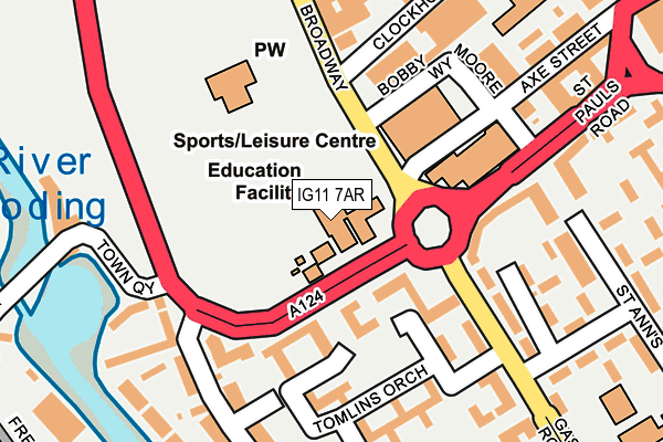
IG11 7AR is located in the Abbey electoral ward, within the London borough of Barking and Dagenham and the English Parliamentary constituency of Barking. The Sub Integrated Care Board (ICB) Location is NHS North East London ICB - A3A8R and the police force is Metropolitan Police. This postcode has been in use since January 1980.


GetTheData
Source: OS OpenMap – Local (Ordnance Survey)
Source: OS VectorMap District (Ordnance Survey)
Licence: Open Government Licence (requires attribution)
| Easting | 544161 |
| Northing | 183766 |
| Latitude | 51.534399 |
| Longitude | 0.077080 |
GetTheData
Source: Open Postcode Geo
Licence: Open Government Licence
| Country | England |
| Postcode District | IG11 |
| ➜ IG11 open data dashboard ➜ See where IG11 is on a map ➜ Where is Barking? | |
GetTheData
Source: Land Registry Price Paid Data
Licence: Open Government Licence
Elevation or altitude of IG11 7AR as distance above sea level:
| Metres | Feet | |
|---|---|---|
| Elevation | 10m | 33ft |
Elevation is measured from the approximate centre of the postcode, to the nearest point on an OS contour line from OS Terrain 50, which has contour spacing of ten vertical metres.
➜ How high above sea level am I? Find the elevation of your current position using your device's GPS.
GetTheData
Source: Open Postcode Elevation
Licence: Open Government Licence
| Ward | Abbey |
| Constituency | Barking |
GetTheData
Source: ONS Postcode Database
Licence: Open Government Licence
| January 2024 | Anti-social behaviour | On or near Boundary Road | 485m |
| January 2024 | Burglary | On or near Boundary Road | 485m |
| January 2024 | Criminal damage and arson | On or near Boundary Road | 485m |
| ➜ Get more crime data in our Crime section | |||
GetTheData
Source: data.police.uk
Licence: Open Government Licence
| Broadway Theatre (Broadway) | Barking | 119m |
| Abbey Sports Centre (St Paul's Road) | Barking | 188m |
| Broadway Theatre (North Street) | Barking | 189m |
| Gascoigne Primary School (Gascoigne Road) | Barking | 269m |
| Barking Abbey (North Street) | Barking | 307m |
| Barking Underground Station | Barking | 613m |
| Barking Station | 0.6km |
| Ilford Station | 2.8km |
| Woodgrange Park Station | 2.8km |
GetTheData
Source: NaPTAN
Licence: Open Government Licence
GetTheData
Source: ONS Postcode Database
Licence: Open Government Licence


➜ Get more ratings from the Food Standards Agency
GetTheData
Source: Food Standards Agency
Licence: FSA terms & conditions
| Last Collection | |||
|---|---|---|---|
| Location | Mon-Fri | Sat | Distance |
| Saxham Road | 17:00 | 12:45 | 209m |
| Abbey Road | 17:30 | 12:00 | 212m |
| East Street | 17:30 | 12:00 | 295m |
GetTheData
Source: Dracos
Licence: Creative Commons Attribution-ShareAlike
| Facility | Distance |
|---|---|
| Abbey Sports Centre (Barking) (Closed) Axe Street, Barking Sports Hall, Swimming Pool, Health and Fitness Gym, Studio, Squash Courts | 138m |
| Abbey Leisure Centre Bobby Moore Way, Barking Health and Fitness Gym, Swimming Pool, Studio | 144m |
| St Margarets C Of E Primary School North Street, Barking Grass Pitches, Sports Hall | 273m |
GetTheData
Source: Active Places
Licence: Open Government Licence
| School | Phase of Education | Distance |
|---|---|---|
| St Joseph's Catholic Primary School The Broadway, Barking, IG11 7AR | Primary | 10m |
| St Margarets CofE Primary School 15-19 North Street, Barking, IG11 8AS | Primary | 273m |
| Northstar New School c/o Gascoigne Primary Annex, The Shaftesburys, Barking, IG11 7JA | Not applicable | 309m |
GetTheData
Source: Edubase
Licence: Open Government Licence
The below table lists the International Territorial Level (ITL) codes (formerly Nomenclature of Territorial Units for Statistics (NUTS) codes) and Local Administrative Units (LAU) codes for IG11 7AR:
| ITL 1 Code | Name |
|---|---|
| TLI | London |
| ITL 2 Code | Name |
| TLI5 | Outer London - East and North East |
| ITL 3 Code | Name |
| TLI52 | Barking & Dagenham and Havering |
| LAU 1 Code | Name |
| E09000002 | Barking and Dagenham |
GetTheData
Source: ONS Postcode Directory
Licence: Open Government Licence
The below table lists the Census Output Area (OA), Lower Layer Super Output Area (LSOA), and Middle Layer Super Output Area (MSOA) for IG11 7AR:
| Code | Name | |
|---|---|---|
| OA | E00000062 | |
| LSOA | E01000010 | Barking and Dagenham 015C |
| MSOA | E02000016 | Barking and Dagenham 015 |
GetTheData
Source: ONS Postcode Directory
Licence: Open Government Licence
| IG11 7LE | Hardwicke Street | 144m |
| IG11 7LJ | Linsdell Road | 165m |
| IG11 7LG | Gascoigne Road | 168m |
| IG11 7AL | St Anns | 169m |
| IG11 7LS | Broadway | 171m |
| IG11 7GW | Abbey Road | 181m |
| IG11 7AF | Cooke Street | 185m |
| IG11 7LP | Tomlins Orchard | 187m |
| IG11 7BU | Abbey Road | 190m |
| IG11 7LZ | Axe Street | 190m |
GetTheData
Source: Open Postcode Geo; Land Registry Price Paid Data
Licence: Open Government Licence