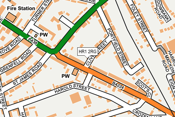
HR1 2RG lies on Clive Street in Hereford. HR1 2RG is located in the Eign Hill electoral ward, within the unitary authority of Herefordshire, County of and the English Parliamentary constituency of Hereford and South Herefordshire. The Sub Integrated Care Board (ICB) Location is NHS Herefordshire and Worcestershire ICB - 18C and the police force is West Mercia. This postcode has been in use since April 2005.


GetTheData
Source: OS OpenMap – Local (Ordnance Survey)
Source: OS VectorMap District (Ordnance Survey)
Licence: Open Government Licence (requires attribution)
| Easting | 351794 |
| Northing | 239561 |
| Latitude | 52.052327 |
| Longitude | -2.704410 |
GetTheData
Source: Open Postcode Geo
Licence: Open Government Licence
| Street | Clive Street |
| Town/City | Hereford |
| Country | England |
| Postcode District | HR1 |
| ➜ HR1 open data dashboard ➜ See where HR1 is on a map ➜ Where is Hereford? | |
GetTheData
Source: Land Registry Price Paid Data
Licence: Open Government Licence
Elevation or altitude of HR1 2RG as distance above sea level:
| Metres | Feet | |
|---|---|---|
| Elevation | 50m | 164ft |
Elevation is measured from the approximate centre of the postcode, to the nearest point on an OS contour line from OS Terrain 50, which has contour spacing of ten vertical metres.
➜ How high above sea level am I? Find the elevation of your current position using your device's GPS.
GetTheData
Source: Open Postcode Elevation
Licence: Open Government Licence
| Ward | Eign Hill |
| Constituency | Hereford And South Herefordshire |
GetTheData
Source: ONS Postcode Database
Licence: Open Government Licence
| June 2022 | Criminal damage and arson | On or near Templars Lane | 142m |
| June 2022 | Criminal damage and arson | On or near Hampton Street | 306m |
| June 2022 | Violence and sexual offences | On or near Ledbury Court | 313m |
| ➜ Clive Street crime map and outcomes | |||
GetTheData
Source: data.police.uk
Licence: Open Government Licence
| St Giles (St Owen's Street) | Hereford | 163m |
| Central Avenue (Ledbury Road. Hereford) | Hereford | 164m |
| St James Road (St Owen's Street) | Hereford | 166m |
| Central Avenue (Ledbury Road) | Hereford | 217m |
| Park Street Shelter (Park Street) | Bartonsham | 227m |
| Hereford Station | 1km |
GetTheData
Source: NaPTAN
Licence: Open Government Licence
| Percentage of properties with Next Generation Access | 100.0% |
| Percentage of properties with Superfast Broadband | 100.0% |
| Percentage of properties with Ultrafast Broadband | 100.0% |
| Percentage of properties with Full Fibre Broadband | 0.0% |
Superfast Broadband is between 30Mbps and 300Mbps
Ultrafast Broadband is > 300Mbps
| Percentage of properties unable to receive 2Mbps | 0.0% |
| Percentage of properties unable to receive 5Mbps | 0.0% |
| Percentage of properties unable to receive 10Mbps | 0.0% |
| Percentage of properties unable to receive 30Mbps | 0.0% |
GetTheData
Source: Ofcom
Licence: Ofcom Terms of Use (requires attribution)
GetTheData
Source: ONS Postcode Database
Licence: Open Government Licence


➜ Get more ratings from the Food Standards Agency
GetTheData
Source: Food Standards Agency
Licence: FSA terms & conditions
| Last Collection | |||
|---|---|---|---|
| Location | Mon-Fri | Sat | Distance |
| Central Avenue | 18:30 | 11:00 | 231m |
| Posting Suite | 19:00 | 13:00 | 301m |
| Mill Street | 17:30 | 11:30 | 443m |
GetTheData
Source: Dracos
Licence: Creative Commons Attribution-ShareAlike
| Facility | Distance |
|---|---|
| Elite Performance (Closed) Foley Trading Estate, Hereford Health and Fitness Gym | 357m |
| St James' C Of E Primary School Vicarage Road, Hereford Grass Pitches | 409m |
| Archways Leisure (Closed) St. Owen Street, Hereford Health and Fitness Gym | 436m |
GetTheData
Source: Active Places
Licence: Open Government Licence
| School | Phase of Education | Distance |
|---|---|---|
| St James' CofE Primary School Vicarage Road, Hereford, HR1 2QN | Primary | 418m |
| Hereford Cathedral Junior School 28 Castle Street, Hereford, HR1 2NW | Not applicable | 634m |
| Hereford Cathedral School Old Deanery, The Cathedral Close, Hereford, HR1 2NG | Not applicable | 748m |
GetTheData
Source: Edubase
Licence: Open Government Licence
The below table lists the International Territorial Level (ITL) codes (formerly Nomenclature of Territorial Units for Statistics (NUTS) codes) and Local Administrative Units (LAU) codes for HR1 2RG:
| ITL 1 Code | Name |
|---|---|
| TLG | West Midlands (England) |
| ITL 2 Code | Name |
| TLG1 | Herefordshire, Worcestershire and Warwickshire |
| ITL 3 Code | Name |
| TLG11 | Herefordshire, County of |
| LAU 1 Code | Name |
| E06000019 | Herefordshire, County of |
GetTheData
Source: ONS Postcode Directory
Licence: Open Government Licence
The below table lists the Census Output Area (OA), Lower Layer Super Output Area (LSOA), and Middle Layer Super Output Area (MSOA) for HR1 2RG:
| Code | Name | |
|---|---|---|
| OA | E00071167 | |
| LSOA | E01014092 | Herefordshire 012F |
| MSOA | E02002916 | Herefordshire 012 |
GetTheData
Source: ONS Postcode Directory
Licence: Open Government Licence
| HR1 2SW | Foxglove Court | 48m |
| HR1 2RY | Eign Road | 50m |
| HR1 2SB | Clive Street | 51m |
| HR1 2RF | Parish Mews | 72m |
| HR1 2SA | Bartonsham Road | 81m |
| HR1 2RU | Eign Road | 115m |
| HR1 2SY | Ledbury Road | 117m |
| HR1 2SE | Portfield Street | 129m |
| HR1 2QX | Harold Street | 139m |
| HR1 2SD | Portfield Street | 150m |
GetTheData
Source: Open Postcode Geo; Land Registry Price Paid Data
Licence: Open Government Licence