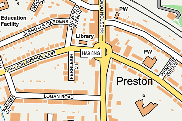
HA9 8NG is located in the Preston electoral ward, within the London borough of Brent and the English Parliamentary constituency of Brent North. The Sub Integrated Care Board (ICB) Location is NHS North West London ICB - W2U3Z and the police force is Metropolitan Police. This postcode has been in use since January 1980.


GetTheData
Source: OS OpenMap – Local (Ordnance Survey)
Source: OS VectorMap District (Ordnance Survey)
Licence: Open Government Licence (requires attribution)
| Easting | 518240 |
| Northing | 187020 |
| Latitude | 51.569663 |
| Longitude | -0.295352 |
GetTheData
Source: Open Postcode Geo
Licence: Open Government Licence
| Country | England |
| Postcode District | HA9 |
| ➜ HA9 open data dashboard ➜ See where HA9 is on a map ➜ Where is London? | |
GetTheData
Source: Land Registry Price Paid Data
Licence: Open Government Licence
Elevation or altitude of HA9 8NG as distance above sea level:
| Metres | Feet | |
|---|---|---|
| Elevation | 40m | 131ft |
Elevation is measured from the approximate centre of the postcode, to the nearest point on an OS contour line from OS Terrain 50, which has contour spacing of ten vertical metres.
➜ How high above sea level am I? Find the elevation of your current position using your device's GPS.
GetTheData
Source: Open Postcode Elevation
Licence: Open Government Licence
| Ward | Preston |
| Constituency | Brent North |
GetTheData
Source: ONS Postcode Database
Licence: Open Government Licence
| December 2023 | Violence and sexual offences | On or near Edison Drive | 454m |
| September 2023 | Anti-social behaviour | On or near Edison Drive | 454m |
| September 2023 | Anti-social behaviour | On or near Edison Drive | 454m |
| ➜ Get more crime data in our Crime section | |||
GetTheData
Source: data.police.uk
Licence: Open Government Licence
| The Preston | Preston Road | 22m |
| Carlton Avenue East | Preston Road | 45m |
| Carlton Avenue East | Preston Road | 63m |
| Carlton Avenue East | Preston Road | 145m |
| Preston Road | Preston Road | 252m |
| Preston Road Underground Station | Preston | 257m |
| South Kenton Underground Station | South Kenton | 909m |
| North Wembley Underground Station | North Wembley | 993m |
| Wembley Park Underground Station | Wembley Park | 1,327m |
| South Kenton Station | 0.9km |
| North Wembley Station | 1km |
| Wembley Stadium Station | 1.8km |
GetTheData
Source: NaPTAN
Licence: Open Government Licence
GetTheData
Source: ONS Postcode Database
Licence: Open Government Licence


➜ Get more ratings from the Food Standards Agency
GetTheData
Source: Food Standards Agency
Licence: FSA terms & conditions
| Last Collection | |||
|---|---|---|---|
| Location | Mon-Fri | Sat | Distance |
| Preston Road Post Office | 18:30 | 13:15 | 138m |
| 102 Elmstead Avenue | 17:00 | 12:00 | 469m |
| 324 Preston Road | 18:15 | 12:00 | 530m |
GetTheData
Source: Dracos
Licence: Creative Commons Attribution-ShareAlike
| Facility | Distance |
|---|---|
| Century Bowling And Sports Club Ltd Logan Road, Wembley Indoor Bowls | 318m |
| Pellat Road Sports Ground Pellatt Road, Wembley Grass Pitches | 321m |
| Preston Park Primary School College Road, Wembley Grass Pitches | 358m |
GetTheData
Source: Active Places
Licence: Open Government Licence
| School | Phase of Education | Distance |
|---|---|---|
| Preston Park Primary School College Road, Preston Park Primary School, Wembley, HA9 8RJ | Primary | 342m |
| Ashley College Ashley Gardens, Wembley, HA9 8NP | Not applicable | 422m |
| Preston Manor School Carlton Avenue East, Wembley, HA9 8NA | All-through | 595m |
GetTheData
Source: Edubase
Licence: Open Government Licence
The below table lists the International Territorial Level (ITL) codes (formerly Nomenclature of Territorial Units for Statistics (NUTS) codes) and Local Administrative Units (LAU) codes for HA9 8NG:
| ITL 1 Code | Name |
|---|---|
| TLI | London |
| ITL 2 Code | Name |
| TLI7 | Outer London - West and North West |
| ITL 3 Code | Name |
| TLI72 | Brent |
| LAU 1 Code | Name |
| E09000005 | Brent |
GetTheData
Source: ONS Postcode Directory
Licence: Open Government Licence
The below table lists the Census Output Area (OA), Lower Layer Super Output Area (LSOA), and Middle Layer Super Output Area (MSOA) for HA9 8NG:
| Code | Name | |
|---|---|---|
| OA | E00002806 | |
| LSOA | E01000575 | Brent 007D |
| MSOA | E02000099 | Brent 007 |
GetTheData
Source: ONS Postcode Directory
Licence: Open Government Licence
| HA9 8PN | Carlton Avenue East | 43m |
| HA9 8NQ | Preston Road | 79m |
| HA9 8PW | Fernleigh Court | 92m |
| HA9 8PA | Preston Road | 96m |
| HA9 8PP | Longfield Avenue | 117m |
| HA9 8NB | Carlton Avenue East | 148m |
| HA9 8NW | Preston Road | 150m |
| HA9 8ND | Carlton Avenue East | 151m |
| HA9 8PJ | Aylands Close | 154m |
| HA9 8PX | Logan Road | 165m |
GetTheData
Source: Open Postcode Geo; Land Registry Price Paid Data
Licence: Open Government Licence